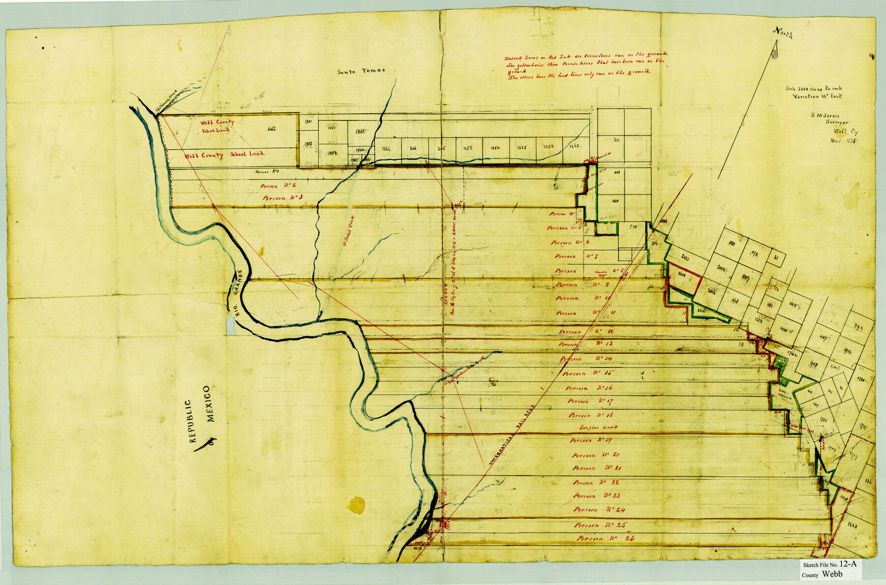
Webb County Sketch File 12a
[Sketch of Porciones north of Laredo]
-
Map/Doc
12628
-
Collection
General Map Collection
-
Object Dates
11/1/1886 (Creation Date)
1/3/1887 (File Date)
-
People and Organizations
Samuel M. Jarvis (Surveyor/Engineer)
-
Counties
Webb
-
Subjects
Surveying Sketch File
-
Height x Width
20.7 x 31.4 inches
52.6 x 79.8 cm
-
Medium
paper, manuscript
-
Features
San Tomas Creek
Rio Grande
St. Isabel Creek
Sombrerotitto Creek
Part of: General Map Collection
Kimble County

Print $40.00
- Digital $50.00
Kimble County
1890
Size 37.4 x 58.6 inches
Map/Doc 16866
Tyler County Working Sketch 17

Print $20.00
- Digital $50.00
Tyler County Working Sketch 17
1962
Size 33.1 x 38.9 inches
Map/Doc 69487
State of Texas

Print $40.00
- Digital $50.00
State of Texas
1985
Size 50.0 x 53.6 inches
Map/Doc 2486
Fisher County Working Sketch 18

Print $20.00
- Digital $50.00
Fisher County Working Sketch 18
1941
Size 24.7 x 16.6 inches
Map/Doc 69152
Crockett County Rolled Sketch 50

Print $20.00
- Digital $50.00
Crockett County Rolled Sketch 50
1940
Size 31.5 x 40.7 inches
Map/Doc 8714
Flight Mission No. DQO-14T, Frame 65, Galveston County

Print $20.00
- Digital $50.00
Flight Mission No. DQO-14T, Frame 65, Galveston County
1958
Size 17.6 x 17.4 inches
Map/Doc 85216
Flight Mission No. DAG-26K, Frame 80, Matagorda County

Print $20.00
- Digital $50.00
Flight Mission No. DAG-26K, Frame 80, Matagorda County
1953
Size 18.5 x 22.3 inches
Map/Doc 86585
Chambers County Sketch File 46

Print $356.00
- Digital $50.00
Chambers County Sketch File 46
1927
Size 20.7 x 7.3 inches
Map/Doc 17751
Live Oak County Boundary File 9

Print $4.00
- Digital $50.00
Live Oak County Boundary File 9
Size 12.7 x 7.8 inches
Map/Doc 56399
Map of Hopkins County

Print $20.00
- Digital $50.00
Map of Hopkins County
1863
Size 22.6 x 24.1 inches
Map/Doc 3679
Bexar County Sketch File 41

Print $4.00
- Digital $50.00
Bexar County Sketch File 41
Size 8.3 x 5.3 inches
Map/Doc 14516
Harris County Sketch File 110

Print $26.00
- Digital $50.00
Harris County Sketch File 110
2009
Size 11.0 x 8.5 inches
Map/Doc 89586
You may also like
Zapata County Rolled Sketch 10A

Print $20.00
- Digital $50.00
Zapata County Rolled Sketch 10A
1912
Size 26.3 x 26.5 inches
Map/Doc 8312
Sterling County Sketch File 19

Print $8.00
- Digital $50.00
Sterling County Sketch File 19
1949
Size 11.2 x 8.6 inches
Map/Doc 37169
San Saba County Sketch File 8

Print $6.00
- Digital $50.00
San Saba County Sketch File 8
Size 6.6 x 7.9 inches
Map/Doc 36430
Schleicher County Sketch File 47

Print $4.00
- Digital $50.00
Schleicher County Sketch File 47
1953
Size 4.4 x 8.7 inches
Map/Doc 36556
Crockett County Rolled Sketch 27A

Print $40.00
- Digital $50.00
Crockett County Rolled Sketch 27A
1925
Size 22.3 x 59.5 inches
Map/Doc 8692
Newton County Working Sketch 43

Print $20.00
- Digital $50.00
Newton County Working Sketch 43
1982
Size 20.7 x 28.6 inches
Map/Doc 71289
Young County Rolled Sketch 6

Print $20.00
- Digital $50.00
Young County Rolled Sketch 6
Size 43.4 x 30.8 inches
Map/Doc 8294
Flight Mission No. DAG-23K, Frame 169, Matagorda County

Print $20.00
- Digital $50.00
Flight Mission No. DAG-23K, Frame 169, Matagorda County
1953
Size 16.0 x 15.8 inches
Map/Doc 86507
Runnels County Sketch File C

Print $4.00
Runnels County Sketch File C
Size 14.2 x 8.8 inches
Map/Doc 35457
Coryell County Working Sketch 22

Print $20.00
- Digital $50.00
Coryell County Working Sketch 22
1976
Size 24.9 x 35.3 inches
Map/Doc 68229
Map of the southern states, including rail roads, county towns, state capitals, county roads, the southern coast from Delaware to Texas, showing the harbors, inlets, forts and position of blockading ships

Print $20.00
- Digital $50.00
Map of the southern states, including rail roads, county towns, state capitals, county roads, the southern coast from Delaware to Texas, showing the harbors, inlets, forts and position of blockading ships
1863
Size 22.1 x 32.3 inches
Map/Doc 96635
Flight Mission No. DQO-3K, Frame 28, Galveston County

Print $20.00
- Digital $50.00
Flight Mission No. DQO-3K, Frame 28, Galveston County
1952
Size 18.1 x 22.3 inches
Map/Doc 85069