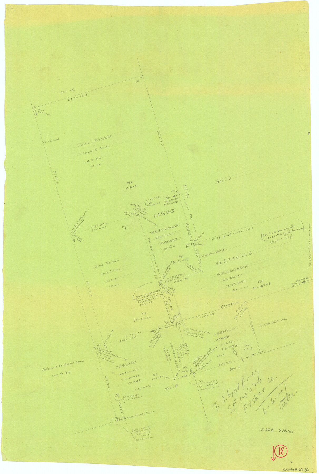
Fisher County Working Sketch 18
-
Map/Doc
69152
-
Collection
General Map Collection
-
Object Dates
6/6/1941 (Creation Date)
-
People and Organizations
Tom Atlee (Draftsman)
-
Counties
Fisher
-
Subjects
Surveying Working Sketch
-
Height x Width
24.7 x 16.6 inches
62.7 x 42.2 cm
-
Comments
Reverse side has Madison County Working Sketch 14, counter No. 78204.
Part of: General Map Collection
Connected Map of Austin's Colony (1892 tracing)

Print $40.00
- Digital $50.00
Connected Map of Austin's Colony (1892 tracing)
1837
Size 90.8 x 46.5 inches
Map/Doc 93359
Reeves County Working Sketch 18

Print $20.00
- Digital $50.00
Reeves County Working Sketch 18
1961
Size 24.7 x 40.2 inches
Map/Doc 63461
Hudspeth County Sketch File 35

Print $20.00
- Digital $50.00
Hudspeth County Sketch File 35
1886
Size 43.0 x 14.7 inches
Map/Doc 10497
Houston County

Print $20.00
- Digital $50.00
Houston County
1868
Size 24.3 x 25.0 inches
Map/Doc 4568
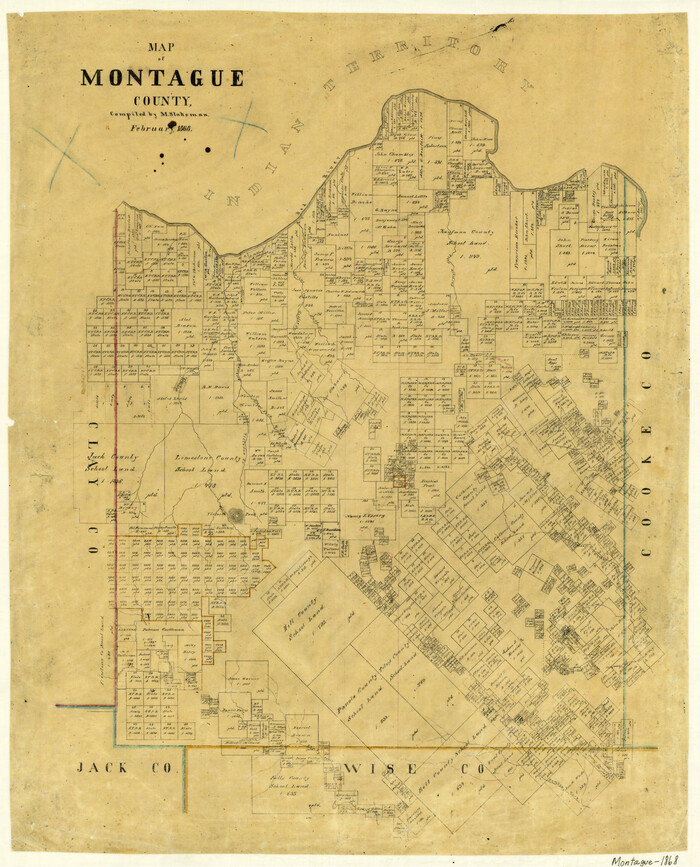
Map of Montague County
Print $20.00
- Digital $50.00
Map of Montague County
1868
Size 24.1 x 19.7 inches
Map/Doc 3887
Brewster County Rolled Sketch 91

Print $20.00
- Digital $50.00
Brewster County Rolled Sketch 91
1949
Size 27.5 x 15.3 inches
Map/Doc 5249
Flight Mission No. DAG-21K, Frame 29, Matagorda County

Print $20.00
- Digital $50.00
Flight Mission No. DAG-21K, Frame 29, Matagorda County
1952
Size 18.5 x 16.1 inches
Map/Doc 86396
Carte du Texas, Extraite de la grande Carte du Mexique par A. Brué Géographe du Roi, Revue, corrigée et considerablement augmentée d'après des documens récens et renseignemens fournis par Mr. le Docteur Fc. Leclerc

Print $20.00
- Digital $50.00
Carte du Texas, Extraite de la grande Carte du Mexique par A. Brué Géographe du Roi, Revue, corrigée et considerablement augmentée d'après des documens récens et renseignemens fournis par Mr. le Docteur Fc. Leclerc
1840
Size 12.6 x 14.2 inches
Map/Doc 94273
Monterey Harbor, California

Print $20.00
- Digital $50.00
Monterey Harbor, California
1852
Size 15.7 x 13.8 inches
Map/Doc 97230
Aransas County Rolled Sketch 35

Print $40.00
- Digital $50.00
Aransas County Rolled Sketch 35
2006
Size 37.5 x 50.0 inches
Map/Doc 83555
Waller County Boundary File 1

Print $8.00
- Digital $50.00
Waller County Boundary File 1
Size 11.4 x 8.9 inches
Map/Doc 59663
Val Verde County Rolled Sketch 84

Print $20.00
- Digital $50.00
Val Verde County Rolled Sketch 84
2006
Size 31.2 x 35.4 inches
Map/Doc 84802
You may also like
[Surveys in Guadalupe and Wilson Counties]
![59, [Surveys in Guadalupe and Wilson Counties], General Map Collection](https://historictexasmaps.com/wmedia_w700/maps/59.tif.jpg)
Print $2.00
- Digital $50.00
[Surveys in Guadalupe and Wilson Counties]
Size 6.0 x 12.2 inches
Map/Doc 59
Genl. Austins Map of Texas With Parts of the Adjoining States

Print $20.00
- Digital $50.00
Genl. Austins Map of Texas With Parts of the Adjoining States
1840
Size 30.6 x 25.3 inches
Map/Doc 93860
Montgomery County Sketch File 17

Print $42.00
- Digital $50.00
Montgomery County Sketch File 17
1912
Size 8.6 x 7.8 inches
Map/Doc 31832
Andrews County Rolled Sketch 45

Print $40.00
- Digital $50.00
Andrews County Rolled Sketch 45
1946
Size 111.7 x 41.0 inches
Map/Doc 8402
Jack County Rolled Sketch 2

Print $20.00
- Digital $50.00
Jack County Rolled Sketch 2
1972
Size 31.3 x 29.0 inches
Map/Doc 6332
Gregg County School Land League 2

Print $2.00
- Digital $50.00
Gregg County School Land League 2
Size 9.0 x 9.3 inches
Map/Doc 90541
[Aerial Photograph of Galveston Island and the Gulf of Mexico]
![83434, [Aerial Photograph of Galveston Island and the Gulf of Mexico], General Map Collection](https://historictexasmaps.com/wmedia_w700/maps/83434.tif.jpg)
Print $20.00
- Digital $50.00
[Aerial Photograph of Galveston Island and the Gulf of Mexico]
1956
Size 15.5 x 12.7 inches
Map/Doc 83434
Harris County Working Sketch 75

Print $20.00
- Digital $50.00
Harris County Working Sketch 75
1964
Size 29.7 x 32.3 inches
Map/Doc 65967
Controlled Mosaic by Jack Amman Photogrammetric Engineers, Inc - Sheet 51

Print $20.00
- Digital $50.00
Controlled Mosaic by Jack Amman Photogrammetric Engineers, Inc - Sheet 51
1954
Size 20.0 x 24.0 inches
Map/Doc 83510
[Right of Way & Track Map, The Texas & Pacific Ry. Co. Main Line]
![64686, [Right of Way & Track Map, The Texas & Pacific Ry. Co. Main Line], General Map Collection](https://historictexasmaps.com/wmedia_w700/maps/64686.tif.jpg)
Print $20.00
- Digital $50.00
[Right of Way & Track Map, The Texas & Pacific Ry. Co. Main Line]
Size 11.0 x 19.0 inches
Map/Doc 64686

Duval County Working Sketch 38

Print $20.00
- Digital $50.00
Duval County Working Sketch 38
1960
Size 18.3 x 22.8 inches
Map/Doc 68762