Hudspeth County Sketch File 35
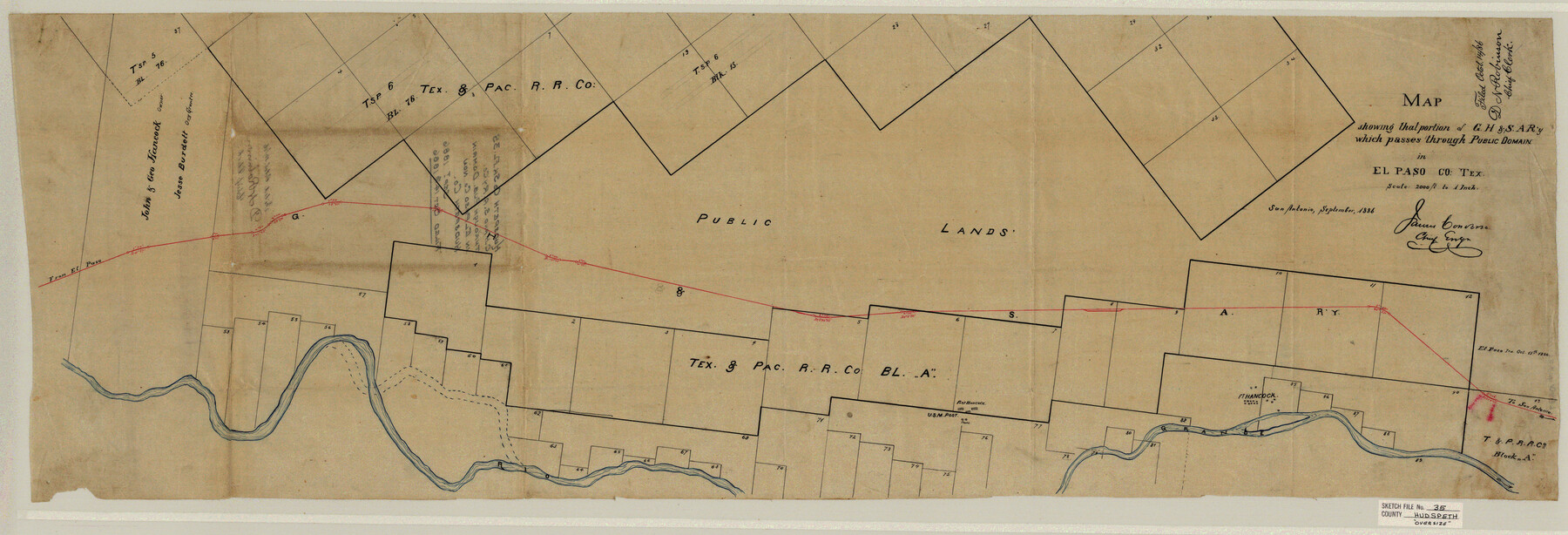
Map showing that portion of G.H.&S.A. Ry. which passes through Pulbic Domain in El Paso Co. Tex.
-
Map/Doc
10497
-
Collection
General Map Collection
-
Object Dates
9/1886 (Creation Date)
10/14/1886 (File Date)
9/1886 (Survey Date)
-
People and Organizations
James Converse (Surveyor/Engineer)
-
Counties
Hudspeth
-
Subjects
Surveying Sketch File
-
Height x Width
43.0 x 14.7 inches
109.2 x 37.3 cm
-
Medium
paper, manuscript
-
Scale
1" = 2000 varas
-
Features
Road from El Paso to San Antonio
GH&SA
Fort Hancock
Rio Grande
Part of: General Map Collection
[Galveston, Harrisburg & San Antonio through El Paso County]
![64014, [Galveston, Harrisburg & San Antonio through El Paso County], General Map Collection](https://historictexasmaps.com/wmedia_w700/maps/64014.tif.jpg)
Print $20.00
- Digital $50.00
[Galveston, Harrisburg & San Antonio through El Paso County]
1906
Size 13.4 x 33.8 inches
Map/Doc 64014
Flight Mission No. BRE-1P, Frame 68, Nueces County

Print $20.00
- Digital $50.00
Flight Mission No. BRE-1P, Frame 68, Nueces County
1956
Size 17.7 x 21.8 inches
Map/Doc 86650
Palo Pinto County Boundary File 4

Print $17.00
- Digital $50.00
Palo Pinto County Boundary File 4
Size 9.0 x 8.4 inches
Map/Doc 57811
Flight Mission No. DAG-28K, Frame 24, Matagorda County

Print $20.00
- Digital $50.00
Flight Mission No. DAG-28K, Frame 24, Matagorda County
1953
Size 16.2 x 16.0 inches
Map/Doc 86592
Jefferson County Rolled Sketch 21

Print $20.00
- Digital $50.00
Jefferson County Rolled Sketch 21
Size 12.0 x 12.1 inches
Map/Doc 6387
Flight Mission No. BQY-4M, Frame 55, Harris County

Print $20.00
- Digital $50.00
Flight Mission No. BQY-4M, Frame 55, Harris County
1953
Size 18.5 x 22.3 inches
Map/Doc 85264
Howard County Working Sketch 9b

Print $20.00
- Digital $50.00
Howard County Working Sketch 9b
1962
Size 33.9 x 37.4 inches
Map/Doc 66277
Presidio County Rolled Sketch 80B

Print $20.00
- Digital $50.00
Presidio County Rolled Sketch 80B
1943
Size 17.4 x 18.3 inches
Map/Doc 2060

Flight Mission No. DCL-7C, Frame 135, Kenedy County

Print $20.00
- Digital $50.00
Flight Mission No. DCL-7C, Frame 135, Kenedy County
1943
Size 15.5 x 15.3 inches
Map/Doc 86092
Culberson County Working Sketch 60

Print $40.00
- Digital $50.00
Culberson County Working Sketch 60
1974
Size 74.7 x 32.7 inches
Map/Doc 68514
Township 5 South Range 13 West, South Western District, Louisiana

Print $20.00
- Digital $50.00
Township 5 South Range 13 West, South Western District, Louisiana
1879
Size 19.3 x 24.8 inches
Map/Doc 65885
You may also like
Galveston to Rio Grande

Print $20.00
- Digital $50.00
Galveston to Rio Grande
1946
Size 44.6 x 36.6 inches
Map/Doc 69952

Travis County Rolled Sketch 49

Print $20.00
- Digital $50.00
Travis County Rolled Sketch 49
Size 43.0 x 39.9 inches
Map/Doc 10017
Zavala County

Print $40.00
- Digital $50.00
Zavala County
1977
Size 43.6 x 49.3 inches
Map/Doc 95684
Goliad County Sketch File 35

Print $20.00
- Digital $50.00
Goliad County Sketch File 35
1924
Size 22.8 x 27.6 inches
Map/Doc 11570
Duval County Sketch File 7

Print $4.00
- Digital $50.00
Duval County Sketch File 7
1875
Size 10.9 x 8.6 inches
Map/Doc 21294
Burnet County Sketch File 27a

Print $10.00
- Digital $50.00
Burnet County Sketch File 27a
1876
Size 8.7 x 8.2 inches
Map/Doc 16732
Flight Mission No. CLL-1N, Frame 184, Willacy County

Print $20.00
- Digital $50.00
Flight Mission No. CLL-1N, Frame 184, Willacy County
1954
Size 18.4 x 22.1 inches
Map/Doc 87054
[Sketch for Mineral Application 33721 - 33725 Incl. - Padre and Mustang Island]
![2876, [Sketch for Mineral Application 33721 - 33725 Incl. - Padre and Mustang Island], General Map Collection](https://historictexasmaps.com/wmedia_w700/maps/2876.tif.jpg)
Print $20.00
- Digital $50.00
[Sketch for Mineral Application 33721 - 33725 Incl. - Padre and Mustang Island]
1942
Size 29.1 x 23.0 inches
Map/Doc 2876
Nacogdoches County Boundary File 1

Print $36.00
- Digital $50.00
Nacogdoches County Boundary File 1
Size 6.7 x 4.4 inches
Map/Doc 57562
Reconnaissance of Aransas Pass, Texas

Print $20.00
Reconnaissance of Aransas Pass, Texas
1853
Size 14.9 x 12.4 inches
Map/Doc 76250
Dallam County Working Sketch 2a

Print $20.00
- Digital $50.00
Dallam County Working Sketch 2a
1886
Size 17.9 x 15.9 inches
Map/Doc 78213