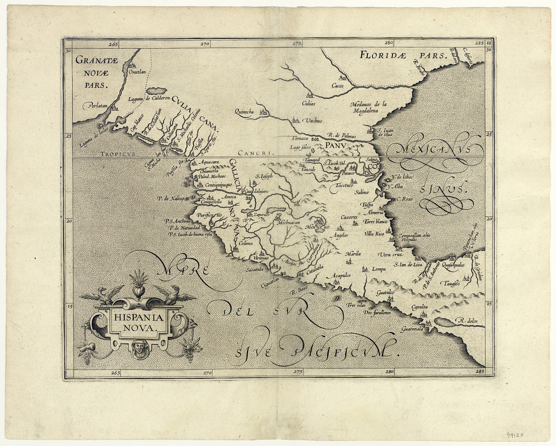
Hispania Nova
-
Map/Doc
94120
-
Collection
General Map Collection
-
Object Dates
1597 (Creation Date)
-
People and Organizations
[Cornelius Van Wytfliet] (Cartographer)
-
Subjects
Gulf of Mexico Spanish Texas
-
Height x Width
12.0 x 14.9 inches
30.5 x 37.9 cm
-
Medium
paper, etching/engraving/lithograph
Part of: General Map Collection
Fannin County Rolled Sketch 18E

Print $2.00
- Digital $50.00
Fannin County Rolled Sketch 18E
Size 9.5 x 8.2 inches
Map/Doc 5872
Panola County Sketch File 27

Print $8.00
- Digital $50.00
Panola County Sketch File 27
1850
Size 5.4 x 7.7 inches
Map/Doc 33498
Flight Mission No. DQO-3K, Frame 82, Galveston County

Print $20.00
- Digital $50.00
Flight Mission No. DQO-3K, Frame 82, Galveston County
1952
Size 18.7 x 22.5 inches
Map/Doc 85087
Mitchell County Boundary File 1

Print $38.00
- Digital $50.00
Mitchell County Boundary File 1
Size 9.1 x 8.4 inches
Map/Doc 57334
Flight Mission No. BRA-8M, Frame 87, Jefferson County

Print $20.00
- Digital $50.00
Flight Mission No. BRA-8M, Frame 87, Jefferson County
1953
Size 18.6 x 22.3 inches
Map/Doc 85607
[Plat of Boundary Line between Comal and Hays Counties]
![65328, [Plat of Boundary Line between Comal and Hays Counties], General Map Collection](https://historictexasmaps.com/wmedia_w700/pdf_converted_jpg/qi_pdf_thumbnail_19768.jpg)
Print $20.00
- Digital $50.00
[Plat of Boundary Line between Comal and Hays Counties]
1947
Size 11.4 x 17.7 inches
Map/Doc 65328
[Sketch for Mineral Application 13436 - Cut-off Bayou]
![65676, [Sketch for Mineral Application 13436 - Cut-off Bayou], General Map Collection](https://historictexasmaps.com/wmedia_w700/maps/65676-1.tif.jpg)
Print $20.00
- Digital $50.00
[Sketch for Mineral Application 13436 - Cut-off Bayou]
1928
Size 44.1 x 21.6 inches
Map/Doc 65676
Briscoe County Boundary File 7

Print $6.00
- Digital $50.00
Briscoe County Boundary File 7
Size 10.6 x 8.1 inches
Map/Doc 50806
Coleman County Sketch File 43a

Print $6.00
- Digital $50.00
Coleman County Sketch File 43a
1892
Size 13.2 x 8.2 inches
Map/Doc 18780

Comanche County Working Sketch 20

Print $20.00
- Digital $50.00
Comanche County Working Sketch 20
1973
Size 20.5 x 15.6 inches
Map/Doc 68154
Topographical Map of the Rio Grande, Sheet No. 8

Print $20.00
- Digital $50.00
Topographical Map of the Rio Grande, Sheet No. 8
1912
Map/Doc 89532
You may also like
Freestone County Sketch File 6

Print $4.00
- Digital $50.00
Freestone County Sketch File 6
1858
Size 10.3 x 8.8 inches
Map/Doc 23050
Crockett County Rolled Sketch 70

Print $20.00
- Digital $50.00
Crockett County Rolled Sketch 70
1949
Size 15.1 x 17.0 inches
Map/Doc 5612

Collingsworth County Working Sketch 6

Print $20.00
- Digital $50.00
Collingsworth County Working Sketch 6
1990
Size 37.7 x 41.8 inches
Map/Doc 68094
Reeves County Rolled Sketch 4

Print $20.00
- Digital $50.00
Reeves County Rolled Sketch 4
1891
Size 23.9 x 39.6 inches
Map/Doc 7476
Anton Townsite Situated on Parts of Sections 106 and 113 Block A, R. M. Thomson, Grantee Hockley County, Texas

Print $20.00
- Digital $50.00
Anton Townsite Situated on Parts of Sections 106 and 113 Block A, R. M. Thomson, Grantee Hockley County, Texas
Size 30.7 x 34.5 inches
Map/Doc 92217
Jack County Sketch File 14 1/2

Print $4.00
- Digital $50.00
Jack County Sketch File 14 1/2
1876
Size 8.5 x 12.7 inches
Map/Doc 27543
Fayette County Working Sketch 1

Print $20.00
- Digital $50.00
Fayette County Working Sketch 1
1949
Size 25.4 x 18.0 inches
Map/Doc 69165
Throckmorton County Rolled Sketch 3A

Print $20.00
- Digital $50.00
Throckmorton County Rolled Sketch 3A
Size 30.7 x 37.4 inches
Map/Doc 7987
Flight Mission No. CUG-1P, Frame 159, Kleberg County

Print $20.00
- Digital $50.00
Flight Mission No. CUG-1P, Frame 159, Kleberg County
1956
Size 18.5 x 22.3 inches
Map/Doc 86166
Map of Polk County

Print $20.00
- Digital $50.00
Map of Polk County
1879
Size 27.1 x 20.8 inches
Map/Doc 3959
[Map of Parker County]
![3948, [Map of Parker County], General Map Collection](https://historictexasmaps.com/wmedia_w700/maps/3948.tif.jpg)
Print $20.00
- Digital $50.00
[Map of Parker County]
1889
Size 25.9 x 32.9 inches
Map/Doc 3948