Reeves County Rolled Sketch 4
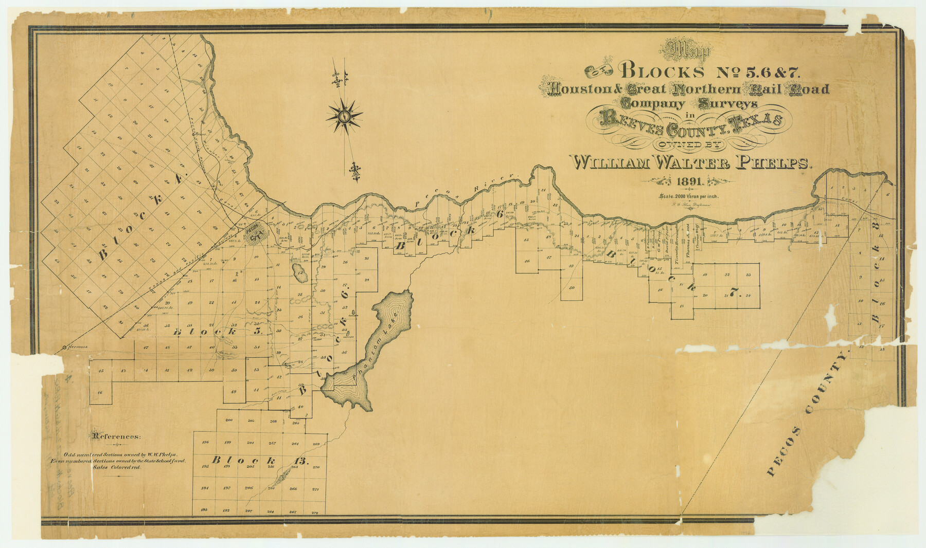
Map of Blocks no. 5, 6, & 7, Houston & Great Northern Rail Road Company surveys in Reeves County, Texas owned by William Walter Phelps
-
Map/Doc
7476
-
Collection
General Map Collection
-
Object Dates
1891 (Creation Date)
-
People and Organizations
F.G. Blau (Draftsman)
-
Counties
Reeves
-
Subjects
Surveying Rolled Sketch
-
Height x Width
23.9 x 39.6 inches
60.7 x 100.6 cm
-
Medium
paper, etching/engraving/lithograph
-
Scale
1" = 2000 varas
-
Comments
Adopted in 2008 by Glen Sample Ely
Part of: General Map Collection
Chambers County Sketch File 52

Print $8.00
- Digital $50.00
Chambers County Sketch File 52
1839
Size 13.0 x 8.3 inches
Map/Doc 18083
Intracoastal Waterway - Galveston Bay to West Bay including Galveston Bay Entrance

Print $20.00
- Digital $50.00
Intracoastal Waterway - Galveston Bay to West Bay including Galveston Bay Entrance
1961
Size 26.9 x 38.9 inches
Map/Doc 69935
Flight Mission No. DCL-6C, Frame 68, Kenedy County

Print $20.00
- Digital $50.00
Flight Mission No. DCL-6C, Frame 68, Kenedy County
1943
Size 18.6 x 22.4 inches
Map/Doc 85910
Rains County Sketch File 1

Print $6.00
- Digital $50.00
Rains County Sketch File 1
Size 5.9 x 9.1 inches
Map/Doc 34942
Topographical Map of the Rio Grande, Sheet No. 10

Print $20.00
- Digital $50.00
Topographical Map of the Rio Grande, Sheet No. 10
1912
Map/Doc 89534
Flight Mission No. CUG-3P, Frame 83, Kleberg County

Print $20.00
- Digital $50.00
Flight Mission No. CUG-3P, Frame 83, Kleberg County
1956
Size 18.7 x 22.4 inches
Map/Doc 86258
Texas Intracoastal Waterway - Stover Point to Port Brownsville including Brazos Santiago

Print $20.00
- Digital $50.00
Texas Intracoastal Waterway - Stover Point to Port Brownsville including Brazos Santiago
1957
Size 27.6 x 38.9 inches
Map/Doc 73518
Flight Mission No. CRK-3P, Frame 127, Refugio County

Print $20.00
- Digital $50.00
Flight Mission No. CRK-3P, Frame 127, Refugio County
1956
Size 18.6 x 22.3 inches
Map/Doc 86915
Brewster County Sketch File 18

Print $8.00
- Digital $50.00
Brewster County Sketch File 18
1942
Size 13.8 x 7.6 inches
Map/Doc 15813
Ochiltree County Sketch File 8

Print $16.00
- Digital $50.00
Ochiltree County Sketch File 8
1933
Size 11.2 x 8.7 inches
Map/Doc 33186
Loving County Working Sketch 22

Print $20.00
- Digital $50.00
Loving County Working Sketch 22
1984
Size 18.3 x 34.9 inches
Map/Doc 70656
Fort Bend County State Real Property Sketch 4

Print $40.00
- Digital $50.00
Fort Bend County State Real Property Sketch 4
1987
Size 36.3 x 47.9 inches
Map/Doc 61678
You may also like
Motley County Sketch File 4 (N)

Print $20.00
- Digital $50.00
Motley County Sketch File 4 (N)
1882
Size 18.3 x 20.8 inches
Map/Doc 42137
Deaf Smith County Sketch File 1 1/2

Print $20.00
- Digital $50.00
Deaf Smith County Sketch File 1 1/2
Size 20.7 x 17.1 inches
Map/Doc 11302
Flight Mission No. DCL-6C, Frame 117, Kenedy County

Print $20.00
- Digital $50.00
Flight Mission No. DCL-6C, Frame 117, Kenedy County
1943
Size 18.5 x 22.2 inches
Map/Doc 85947
Working Sketch in Garza County [J. Hays Block 1]
![90920, Working Sketch in Garza County [J. Hays Block 1], Twichell Survey Records](https://historictexasmaps.com/wmedia_w700/maps/90920-1.tif.jpg)
Print $2.00
- Digital $50.00
Working Sketch in Garza County [J. Hays Block 1]
1903
Size 9.1 x 12.4 inches
Map/Doc 90920
General Highway Map, Terrell County, Texas

Print $20.00
General Highway Map, Terrell County, Texas
1961
Size 24.9 x 18.2 inches
Map/Doc 79674
Randall County Sketch File 1

Print $50.00
- Digital $50.00
Randall County Sketch File 1
1912
Size 24.6 x 35.6 inches
Map/Doc 12205

Bee County Working Sketch 20

Print $20.00
- Digital $50.00
Bee County Working Sketch 20
1982
Size 23.6 x 21.3 inches
Map/Doc 67270
Amended Map of Wildorado Situated in Oldham County, Texas on Sections 14 & 15 Block Z3

Print $20.00
- Digital $50.00
Amended Map of Wildorado Situated in Oldham County, Texas on Sections 14 & 15 Block Z3
Size 14.9 x 18.4 inches
Map/Doc 92095
Kimble County Working Sketch 82

Print $20.00
- Digital $50.00
Kimble County Working Sketch 82
1971
Size 43.3 x 27.7 inches
Map/Doc 70150
Dallas County Working Sketch 2

Print $20.00
- Digital $50.00
Dallas County Working Sketch 2
1917
Size 18.2 x 19.0 inches
Map/Doc 68568
Hidalgo County Sketch File 9

Print $40.00
- Digital $50.00
Hidalgo County Sketch File 9
1904
Size 8.8 x 5.7 inches
Map/Doc 26409