Randall County Sketch File 1
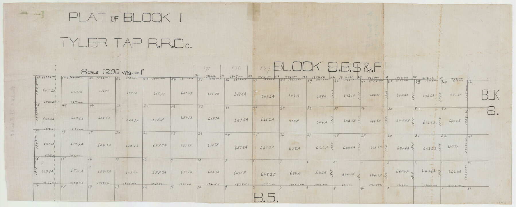
Plat of Block 1, Tyler Tap R.R. Co. [and accompanying correspondence]
-
Map/Doc
12205
-
Collection
General Map Collection
-
Object Dates
9/20/1912 (Creation Date)
-
People and Organizations
G.G. Foster (Surveyor/Engineer)
-
Counties
Randall Deaf Smith
-
Subjects
Surveying Sketch File
-
Height x Width
24.6 x 35.6 inches
62.5 x 90.4 cm
-
Medium
paper, manuscript
-
Scale
1" = 1200 varas
-
Comments
See report of E.A. Giraud on connecting line run by him in 1888, in Bexar Scrip 12662.
Part of: General Map Collection
Midland County Sketch File 1

Print $20.00
- Digital $50.00
Midland County Sketch File 1
1886
Size 25.7 x 16.1 inches
Map/Doc 12079
Irion County Sketch File 3

Print $20.00
- Digital $50.00
Irion County Sketch File 3
1891
Size 22.4 x 22.1 inches
Map/Doc 11823
McMullen County Sketch File 20

Print $4.00
- Digital $50.00
McMullen County Sketch File 20
Size 8.1 x 10.0 inches
Map/Doc 31373
Baylor County Sketch File 23

Print $60.00
- Digital $50.00
Baylor County Sketch File 23
1927
Size 25.2 x 48.9 inches
Map/Doc 10324
Washington County Working Sketch 1

Print $20.00
- Digital $50.00
Washington County Working Sketch 1
1957
Size 25.1 x 25.4 inches
Map/Doc 72362
Edwards County Rolled Sketch 37

Print $20.00
- Digital $50.00
Edwards County Rolled Sketch 37
2018
Size 23.3 x 30.2 inches
Map/Doc 94459
Oldham County Sketch File 8

Print $4.00
- Digital $50.00
Oldham County Sketch File 8
Size 7.9 x 11.9 inches
Map/Doc 33239
San Patricio County Sketch File 42

Print $89.00
- Digital $50.00
San Patricio County Sketch File 42
1979
Size 11.3 x 8.8 inches
Map/Doc 36240
Fayette County Boundary File 6

Print $20.00
- Digital $50.00
Fayette County Boundary File 6
Size 14.4 x 9.0 inches
Map/Doc 53391
Montague County Working Sketch 23

Print $20.00
- Digital $50.00
Montague County Working Sketch 23
1953
Size 31.2 x 27.5 inches
Map/Doc 71089
Visitors' Map of Galveston also showing County Shell Road to Houston

Print $20.00
- Digital $50.00
Visitors' Map of Galveston also showing County Shell Road to Houston
Size 19.6 x 23.9 inches
Map/Doc 95319
[Right of Way Map, Belton Branch of the M.K.&T. RR.]
![64226, [Right of Way Map, Belton Branch of the M.K.&T. RR.], General Map Collection](https://historictexasmaps.com/wmedia_w700/maps/64226.tif.jpg)
Print $20.00
- Digital $50.00
[Right of Way Map, Belton Branch of the M.K.&T. RR.]
1896
Size 7.2 x 21.9 inches
Map/Doc 64226
You may also like
Rusk County Rolled Sketch 8

Print $20.00
- Digital $50.00
Rusk County Rolled Sketch 8
1959
Size 22.6 x 26.3 inches
Map/Doc 7544
Acreage in Texas by Counties

Print $20.00
- Digital $50.00
Acreage in Texas by Counties
Size 19.3 x 20.0 inches
Map/Doc 62974
Map Showing Ten Divisions of the C. C. Slaughter Cattle Company's Ranch in Hockley and Cochran Counties, Texas

Print $3.00
- Digital $50.00
Map Showing Ten Divisions of the C. C. Slaughter Cattle Company's Ranch in Hockley and Cochran Counties, Texas
Size 13.2 x 10.7 inches
Map/Doc 91126
Flight Mission No. CUG-3P, Frame 19, Kleberg County

Print $20.00
- Digital $50.00
Flight Mission No. CUG-3P, Frame 19, Kleberg County
1956
Size 18.7 x 22.3 inches
Map/Doc 86229
National Parks, Monuments and Shrines of the United States and Canada

National Parks, Monuments and Shrines of the United States and Canada
1958
Size 25.7 x 19.7 inches
Map/Doc 92377
[Sketch for Mineral Application 26649-26650 - Sabine River, Harry A. Wolan]
![65565, [Sketch for Mineral Application 26649-26650 - Sabine River, Harry A. Wolan], General Map Collection](https://historictexasmaps.com/wmedia_w700/maps/65565.tif.jpg)
Print $40.00
- Digital $50.00
[Sketch for Mineral Application 26649-26650 - Sabine River, Harry A. Wolan]
Size 36.8 x 71.9 inches
Map/Doc 65565
Flight Mission No. CRC-2R, Frame 55, Chambers County

Print $20.00
- Digital $50.00
Flight Mission No. CRC-2R, Frame 55, Chambers County
1956
Size 18.7 x 22.4 inches
Map/Doc 84728
Maverick County Sketch File 22

Print $32.00
- Digital $50.00
Maverick County Sketch File 22
1892
Size 5.5 x 6.3 inches
Map/Doc 31136
Sabine County Sketch File 8

Print $4.00
Sabine County Sketch File 8
1894
Size 9.7 x 8.4 inches
Map/Doc 35622
Presidio County Sketch File 60b

Print $4.00
- Digital $50.00
Presidio County Sketch File 60b
1936
Size 14.4 x 8.8 inches
Map/Doc 34645
Presidio County Sketch File 82

Print $22.00
- Digital $50.00
Presidio County Sketch File 82
1949
Size 14.3 x 8.8 inches
Map/Doc 34711
Map of Lavaca County

Print $20.00
- Digital $50.00
Map of Lavaca County
1853
Size 20.1 x 20.4 inches
Map/Doc 3801