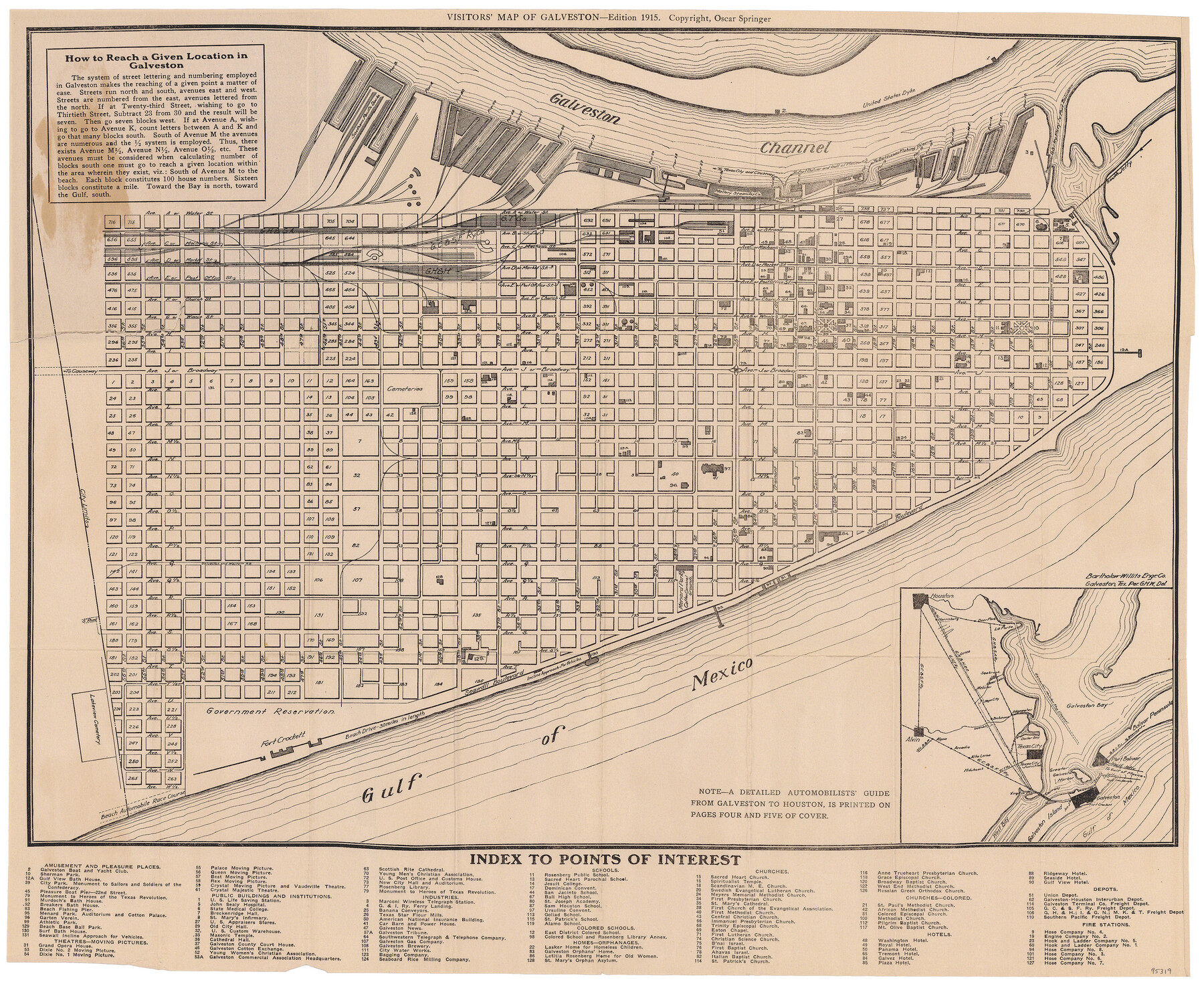
Visitors' Map of Galveston also showing County Shell Road to Houston
-
Map/Doc
95319
-
Collection
General Map Collection
-
Object Dates
1915 (Publication Date)
-
People and Organizations
Oscar Springer (Publisher)
Oscar Springer (Printer)
-
Counties
Galveston
-
Subjects
City
-
Height x Width
19.6 x 23.9 inches
49.8 x 60.7 cm
-
Medium
paper, etching/engraving/lithograph
-
Comments
To view original cover for this map, click "Download PDF" link above.
Part of: General Map Collection
Crosby County Sketch File 21

Print $6.00
- Digital $50.00
Crosby County Sketch File 21
Size 13.8 x 8.8 inches
Map/Doc 20087
Montague County Working Sketch 7

Print $20.00
- Digital $50.00
Montague County Working Sketch 7
1927
Size 41.1 x 28.4 inches
Map/Doc 75970
Brewster County Rolled Sketch 105

Print $20.00
- Digital $50.00
Brewster County Rolled Sketch 105
Size 27.2 x 24.5 inches
Map/Doc 5257
Hamilton County Working Sketch 27

Print $20.00
- Digital $50.00
Hamilton County Working Sketch 27
1975
Size 43.4 x 34.3 inches
Map/Doc 63365

Flight Mission No. BRA-7M, Frame 131, Jefferson County

Print $20.00
- Digital $50.00
Flight Mission No. BRA-7M, Frame 131, Jefferson County
1953
Size 16.2 x 16.0 inches
Map/Doc 85525
Plano General de la Ciudad de Mexico. Levantado Por el Teniente Coronel Don Diego Garcia Conde en el Año de 1793. Aumentado y corregido en lo mas notable Por el Teniente Coronel retirado, Don Rafael Maria Calvo En el de 1830

Print $20.00
- Digital $50.00
Plano General de la Ciudad de Mexico. Levantado Por el Teniente Coronel Don Diego Garcia Conde en el Año de 1793. Aumentado y corregido en lo mas notable Por el Teniente Coronel retirado, Don Rafael Maria Calvo En el de 1830
1793
Size 19.7 x 21.8 inches
Map/Doc 95354
El Paso County Boundary File 19

Print $9.00
- Digital $50.00
El Paso County Boundary File 19
Size 13.6 x 8.7 inches
Map/Doc 53206
[University Lands in El Paso County]
![2426, [University Lands in El Paso County], General Map Collection](https://historictexasmaps.com/wmedia_w700/maps/2426.tif.jpg)
Print $20.00
- Digital $50.00
[University Lands in El Paso County]
1886
Size 29.0 x 43.4 inches
Map/Doc 2426
Flight Mission No. DAH-17M, Frame 66, Orange County

Print $20.00
- Digital $50.00
Flight Mission No. DAH-17M, Frame 66, Orange County
1953
Size 18.6 x 22.3 inches
Map/Doc 86900
Brewster County Working Sketch 28

Print $20.00
- Digital $50.00
Brewster County Working Sketch 28
1940
Size 23.5 x 32.9 inches
Map/Doc 67562
El Paso County Rolled Sketch 57A

Print $40.00
- Digital $50.00
El Paso County Rolled Sketch 57A
1984
Size 49.2 x 39.4 inches
Map/Doc 8879
You may also like
Castro County Sketch File 5

Print $20.00
- Digital $50.00
Castro County Sketch File 5
Size 37.6 x 25.3 inches
Map/Doc 11058
Texas and part of Mexico & the United States, showing the route of the first Santa Fe Expedition

Print $20.00
- Digital $50.00
Texas and part of Mexico & the United States, showing the route of the first Santa Fe Expedition
1844
Size 18.1 x 13.2 inches
Map/Doc 94035
Flight Mission No. CRC-4R, Frame 81, Chambers County

Print $20.00
- Digital $50.00
Flight Mission No. CRC-4R, Frame 81, Chambers County
1956
Size 18.7 x 22.5 inches
Map/Doc 84885
[Blocks 57, 56, 55, 54, 76, 53]
![92928, [Blocks 57, 56, 55, 54, 76, 53], Twichell Survey Records](https://historictexasmaps.com/wmedia_w700/maps/92928-1.tif.jpg)
Print $20.00
- Digital $50.00
[Blocks 57, 56, 55, 54, 76, 53]
Size 36.6 x 23.1 inches
Map/Doc 92928
Lee County Working Sketch 11

Print $20.00
- Digital $50.00
Lee County Working Sketch 11
1980
Size 25.2 x 25.7 inches
Map/Doc 70390
Garza County Rolled Sketch 6D

Print $20.00
- Digital $50.00
Garza County Rolled Sketch 6D
1913
Size 17.4 x 16.0 inches
Map/Doc 5998
Lampasas County Sketch File 6

Print $4.00
- Digital $50.00
Lampasas County Sketch File 6
1871
Size 8.0 x 6.8 inches
Map/Doc 29400
Kendall County

Print $20.00
- Digital $50.00
Kendall County
1946
Size 42.5 x 36.8 inches
Map/Doc 95553
Williamson County Sketch File 30

Print $20.00
- Digital $50.00
Williamson County Sketch File 30
Size 24.6 x 18.7 inches
Map/Doc 12696
Map of Cameron County

Print $40.00
- Digital $50.00
Map of Cameron County
1880
Size 50.3 x 26.5 inches
Map/Doc 4786
Newton County Working Sketch 22

Print $20.00
- Digital $50.00
Newton County Working Sketch 22
1952
Size 25.3 x 43.2 inches
Map/Doc 71268
Mills County Working Sketch 14

Print $20.00
- Digital $50.00
Mills County Working Sketch 14
1946
Size 27.5 x 28.1 inches
Map/Doc 71044