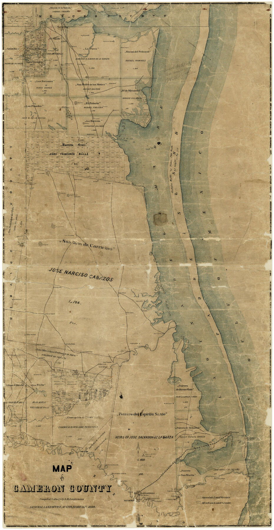
Map of Cameron County
-
Map/Doc
4786
-
Collection
General Map Collection
-
Object Dates
2/1880 (Creation Date)
-
People and Organizations
A.B. Langermann (Draftsman)
-
Counties
Cameron
-
Subjects
County
-
Height x Width
50.3 x 26.5 inches
127.8 x 67.3 cm
-
Comments
Conservation funded in 2001 with donations from Darrell Shine and Nedra Foster.
-
Features
R[anch]o de los Indios
Las Rucias [Ranch]
Carricitos
Clark's Island
Point Isabel Lighthouse
Point Isabel
U. S. Lighthouse
R[anch]o de Carasos
Tampayuas [Ranch]
Tio Cano Lake
R[anch]o San Juan
La[guna] de las Bayns
Brazos Santiago Lighthouse
Fort Venago
La Feria
La[guna] Seso
Cimales [Ranch]
Rodes [Ranch]
Novio Salado
Colimal R[anch]
Cotillo R[anch]
San Pedro [Ranch]
Ojo de Agua [Ranch]
Calaboso [Ranch]
Las Tizones [Ranch]
Fort Brown
Clarksville
Santa Rosalia [Ranch]
R[ancho] de los Tomatos
Rancho de los Falcones
R[ancho] Saino
R[ancho] Sabenitas
Burrita Village
R[anch]o Lomita
R[anch]o San Martin
R[ancho] Saino
R[ancho] del Naranjo
R[ancho] de los Sauses
Arroyo Colorado
Brownsville
R[ancho] Ramer
[S]anta Rita [Ranch]
R[anch]o de Doña Estafana
RGRR
Boca Chica
Potrero de los Blancos
Palo Alto Battle
R[anch]o de San Vincente
San Ysidro
Relamjargo [Ranch]
Palmito R[anch]
Gulf of Mexico
San Pedro
P[otrero] Favias
P[otrero] Canelos
Portreo [sic] Lopeña
La[guna] Del Mesquite
Indios
San Juan
Potrero de la Cancla
Potrero Cortado
Salt Lake
Mota Rata
San Ignacio
Atascosa B[ayou]
Mota Negra
Mota de la Garza
Nombre de Dios [Ranch]
Parra R[anch]
Mota de las Trancos
Paso del Mesquite
Paso Ancho
Paso Diso Landing
Point Penascal
Alazan Bay
San Matias [Ranch]
Bayou Atascoso
Portrero [sic] Largo
Rincon de Guajardo
Isla Cretado
Rincon de Buena Vista
Boca Chica
Cuatizones [Ranch]
General Taylor's Crossing
Paso Real
Las Chatones [Ranch]
Santa Rosa [Ranch]
Santa Rita [Ranch]
Grullo Bayou
Raymondville
Paso de Las Tavernas
Loma Alta [Ranch]
Ovejas [Ranch]
San Juan
El Saus [Ranch]
Chapote [Ranch]
Las Animas
Mogote Sarindo
Mogote Viejo
Saltillo
Part of: General Map Collection
Pecos County Working Sketch 132

Print $40.00
- Digital $50.00
Pecos County Working Sketch 132
1979
Size 34.6 x 49.3 inches
Map/Doc 71606
Upton County Working Sketch 51

Print $20.00
- Digital $50.00
Upton County Working Sketch 51
1980
Size 19.1 x 30.0 inches
Map/Doc 69548
Coleman County Working Sketch 7

Print $20.00
- Digital $50.00
Coleman County Working Sketch 7
1942
Size 38.0 x 47.8 inches
Map/Doc 68073
Hudspeth County Working Sketch 25

Print $20.00
- Digital $50.00
Hudspeth County Working Sketch 25
1971
Size 24.6 x 28.0 inches
Map/Doc 66307
Mexico Comision Pesquisidora de la Frontera del Norte

Mexico Comision Pesquisidora de la Frontera del Norte
1874
Map/Doc 97125
McMullen County Boundary File 7

Print $5.00
- Digital $50.00
McMullen County Boundary File 7
Size 7.2 x 17.0 inches
Map/Doc 57017
La Salle County Working Sketch 5

Print $20.00
- Digital $50.00
La Salle County Working Sketch 5
1915
Size 17.2 x 13.4 inches
Map/Doc 70306
Gregg County Sketch File 7

Print $20.00
- Digital $50.00
Gregg County Sketch File 7
1931
Size 42.9 x 34.8 inches
Map/Doc 10466
Calhoun County Rolled Sketch 12

Print $40.00
- Digital $50.00
Calhoun County Rolled Sketch 12
1940
Size 37.9 x 54.6 inches
Map/Doc 66845
Fort Bend County Rolled Sketch A

Print $20.00
- Digital $50.00
Fort Bend County Rolled Sketch A
1900
Size 19.8 x 29.7 inches
Map/Doc 5903
Harris County Rolled Sketch 83

Print $20.00
- Digital $50.00
Harris County Rolled Sketch 83
1958
Size 28.2 x 45.6 inches
Map/Doc 9139
Tom Green County Sketch File 51

Print $20.00
- Digital $50.00
Tom Green County Sketch File 51
1884
Size 44.0 x 27.5 inches
Map/Doc 10403
You may also like
Leveland and Adjacent Subdivisions of League 28, Hood County School Land Hockley County, Texas

Print $40.00
- Digital $50.00
Leveland and Adjacent Subdivisions of League 28, Hood County School Land Hockley County, Texas
Size 42.4 x 50.4 inches
Map/Doc 89848
Nueces County Sketch File 10

Print $4.00
- Digital $50.00
Nueces County Sketch File 10
Size 8.2 x 10.1 inches
Map/Doc 32516
San Augustine County Working Sketch 1

Print $3.00
- Digital $50.00
San Augustine County Working Sketch 1
1906
Size 9.1 x 11.3 inches
Map/Doc 63688
Current Miscellaneous File 84

Print $10.00
- Digital $50.00
Current Miscellaneous File 84
1954
Size 11.2 x 8.8 inches
Map/Doc 74231
Parker County Sketch File 3

Print $4.00
- Digital $50.00
Parker County Sketch File 3
1856
Size 12.2 x 7.9 inches
Map/Doc 33521
Jack County Working Sketch 24

Print $20.00
- Digital $50.00
Jack County Working Sketch 24
2010
Size 24.1 x 29.7 inches
Map/Doc 90030
Stephens County Working Sketch 33

Print $20.00
- Digital $50.00
Stephens County Working Sketch 33
1978
Size 31.1 x 30.8 inches
Map/Doc 63976
Tyler County Working Sketch 22

Print $20.00
- Digital $50.00
Tyler County Working Sketch 22
1987
Size 42.0 x 35.5 inches
Map/Doc 69492
Leon County Rolled Sketch 3

Print $20.00
- Digital $50.00
Leon County Rolled Sketch 3
Size 16.8 x 22.5 inches
Map/Doc 6595
Presidio County Working Sketch 97

Print $20.00
- Digital $50.00
Presidio County Working Sketch 97
1978
Size 28.2 x 28.0 inches
Map/Doc 71774
General Highway Map Lynn County

Print $20.00
- Digital $50.00
General Highway Map Lynn County
1949
Size 25.8 x 18.8 inches
Map/Doc 92901
Wharton County Working Sketch 7

Print $20.00
- Digital $50.00
Wharton County Working Sketch 7
1989
Size 27.7 x 24.9 inches
Map/Doc 72471