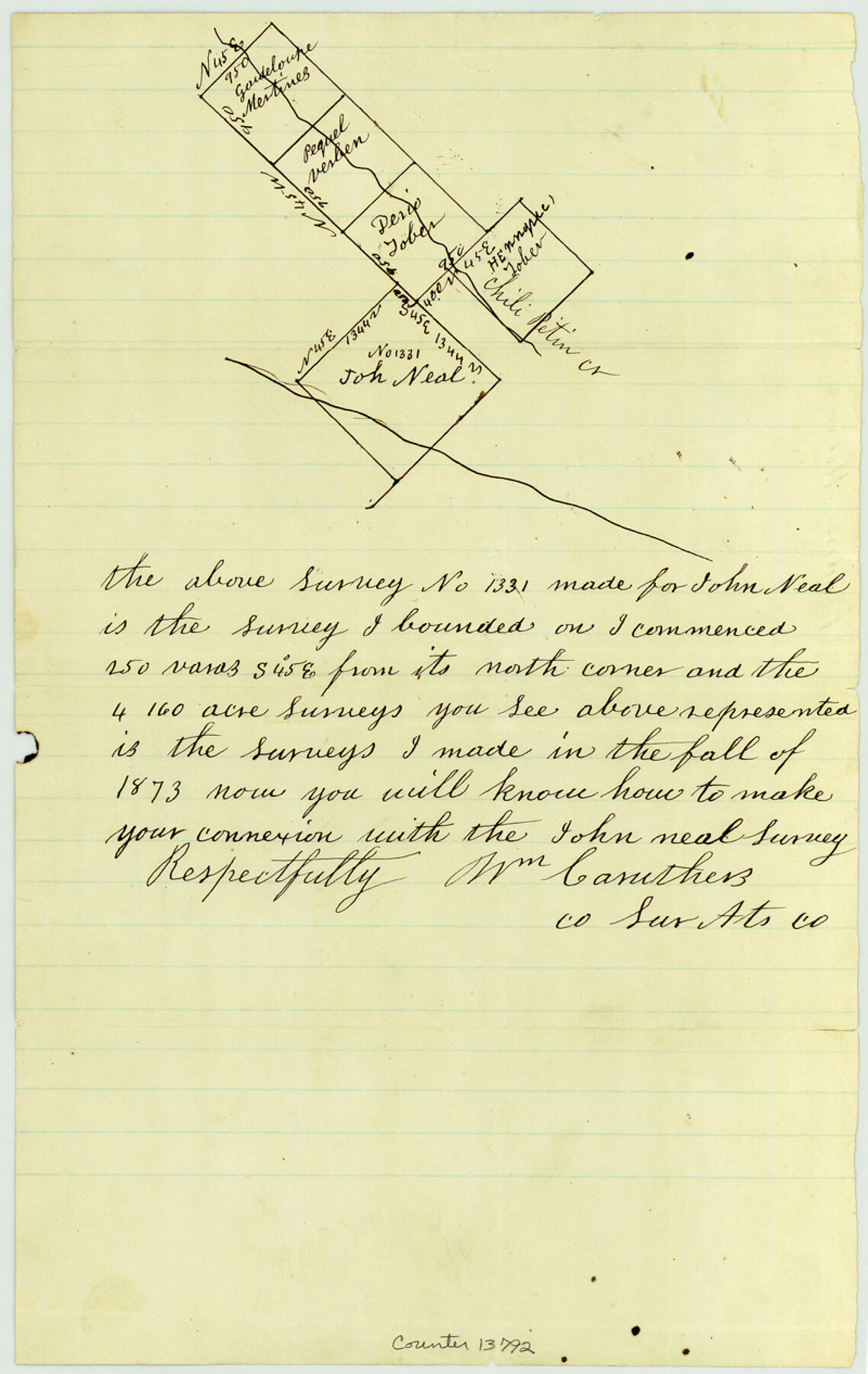
Atascosa County Sketch File 25
[Sketch of surveys on Chiltipin Creek]
-
Map/Doc
13792
-
Collection
General Map Collection
-
Object Dates
1875/11/17 (File Date)
-
People and Organizations
Wm. Caruthers (Surveyor/Engineer)
-
Counties
Atascosa
-
Subjects
Surveying Sketch File
-
Height x Width
12.7 x 8.0 inches
32.3 x 20.3 cm
-
Medium
paper, manuscript
-
Features
Chili Petin [sic] Creek
Part of: General Map Collection
Map of Motley County

Print $20.00
- Digital $50.00
Map of Motley County
1902
Size 43.4 x 37.7 inches
Map/Doc 10799
[Surveys along the Trinity River]
![297, [Surveys along the Trinity River], General Map Collection](https://historictexasmaps.com/wmedia_w700/maps/297.tif.jpg)
Print $3.00
- Digital $50.00
[Surveys along the Trinity River]
Size 17.8 x 9.5 inches
Map/Doc 297
Liberty County Working Sketch 31

Print $20.00
- Digital $50.00
Liberty County Working Sketch 31
1942
Size 23.1 x 42.9 inches
Map/Doc 70490
Zavala County Sketch File 21

Print $4.00
- Digital $50.00
Zavala County Sketch File 21
1915
Size 11.5 x 8.8 inches
Map/Doc 41376
Gregg County Sketch File 1B

Print $4.00
- Digital $50.00
Gregg County Sketch File 1B
1848
Size 12.8 x 8.4 inches
Map/Doc 24538
Jack County Working Sketch 9

Print $20.00
- Digital $50.00
Jack County Working Sketch 9
1955
Size 35.3 x 29.9 inches
Map/Doc 66435
Flight Mission No. DCL-6C, Frame 22, Kenedy County

Print $20.00
- Digital $50.00
Flight Mission No. DCL-6C, Frame 22, Kenedy County
1943
Size 18.6 x 22.3 inches
Map/Doc 85879
PSL Field Notes for Block B13 in Crane, Ector, Ward, and Winkler Counties, Blocks B14 and B16 in Crane and Ector Counties, Blocks B7 and B8 in Ector and Winkler Counties and Block B15 in Ector County

PSL Field Notes for Block B13 in Crane, Ector, Ward, and Winkler Counties, Blocks B14 and B16 in Crane and Ector Counties, Blocks B7 and B8 in Ector and Winkler Counties and Block B15 in Ector County
Map/Doc 81651
Angelina County Working Sketch 31

Print $20.00
- Digital $50.00
Angelina County Working Sketch 31
1955
Size 24.3 x 24.5 inches
Map/Doc 67113
Gonzales County Working Sketch 2

Print $20.00
- Digital $50.00
Gonzales County Working Sketch 2
1920
Size 17.6 x 21.5 inches
Map/Doc 63217
Webb County Sketch File A1

Print $20.00
- Digital $50.00
Webb County Sketch File A1
1897
Size 20.3 x 20.3 inches
Map/Doc 12604
La Salle County Working Sketch 43

Print $20.00
- Digital $50.00
La Salle County Working Sketch 43
1976
Size 32.7 x 40.1 inches
Map/Doc 70344
You may also like
Van Zandt County Sketch File 20

Print $4.00
- Digital $50.00
Van Zandt County Sketch File 20
1858
Size 12.1 x 7.9 inches
Map/Doc 39426
Andrews County Sketch File 18

Print $12.00
- Digital $50.00
Andrews County Sketch File 18
Size 11.3 x 8.9 inches
Map/Doc 12907
Young County Sketch File 12

Print $4.00
- Digital $50.00
Young County Sketch File 12
1889
Size 8.5 x 13.6 inches
Map/Doc 40876
Outer Continental Shelf Leasing Maps (Louisiana Offshore Operations)

Print $20.00
- Digital $50.00
Outer Continental Shelf Leasing Maps (Louisiana Offshore Operations)
1954
Size 25.5 x 15.3 inches
Map/Doc 76093
Galveston County NRC Article 33.136 Sketch 95

Print $40.00
Galveston County NRC Article 33.136 Sketch 95
2024
Map/Doc 97368
San Augustine County Sketch File 6

Print $4.00
San Augustine County Sketch File 6
1858
Size 6.4 x 7.7 inches
Map/Doc 35644
A Pocket Guide to Austin, Texas - Area Map and Downtown Map

A Pocket Guide to Austin, Texas - Area Map and Downtown Map
Size 17.0 x 20.1 inches
Map/Doc 94385
Presidio County Sketch File 6

Print $20.00
- Digital $50.00
Presidio County Sketch File 6
Size 21.3 x 17.8 inches
Map/Doc 11705
Denver to Ft. Worth and the Gulf. Panhandle Route

Print $20.00
Denver to Ft. Worth and the Gulf. Panhandle Route
1888
Size 7.5 x 10.9 inches
Map/Doc 76297
Bee County Sketch File 22

Print $8.00
- Digital $50.00
Bee County Sketch File 22
1878
Size 10.0 x 8.0 inches
Map/Doc 14314
A map of the Anthracite Coal Fields of Pennsylvania embracing all of Schuylkill County and parts of Carbon, Luzerne, Columbia, Northumberland, Dauphin, and Lebanon Counties

Print $20.00
- Digital $50.00
A map of the Anthracite Coal Fields of Pennsylvania embracing all of Schuylkill County and parts of Carbon, Luzerne, Columbia, Northumberland, Dauphin, and Lebanon Counties
1863
Size 27.1 x 39.3 inches
Map/Doc 94054
Crockett County Rolled Sketch 46C

Print $20.00
- Digital $50.00
Crockett County Rolled Sketch 46C
Size 24.5 x 23.8 inches
Map/Doc 5595