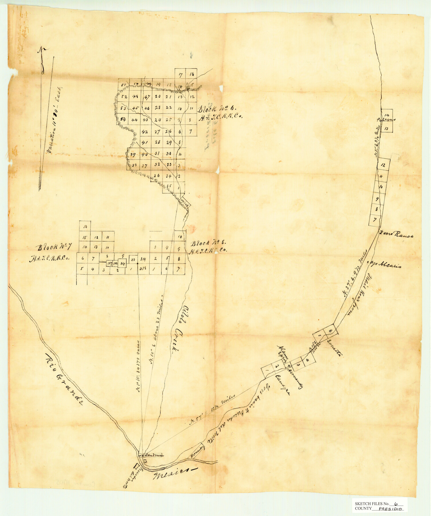
Presidio County Sketch File 6
[Sketch of surveys along Cibolo Creek and along road from Fort Davis to Presidio del Norte]
-
Map/Doc
11705
-
Collection
General Map Collection
-
People and Organizations
Frank R. Sweeney (Draftsman)
John J. Terrell (GLO Commissioner)
-
Counties
Presidio
-
Subjects
Surveying Sketch File
-
Height x Width
21.3 x 17.8 inches
54.1 x 45.2 cm
-
Medium
paper, manuscript
-
Features
Davis Ranch
Cibolo Creek
Rio Grande
[Road from] Fort Davis to Presidio del Norte
Presidio Del Norte
Part of: General Map Collection
Commemorative Map of the Republic of Texas, 1845

Print $27.06
Commemorative Map of the Republic of Texas, 1845
1986
Size 32.7 x 26.7 inches
Map/Doc 89023
Calhoun County NRC Article 33.136 Sketch 15

Print $46.00
Calhoun County NRC Article 33.136 Sketch 15
2025
Map/Doc 97428
Lipscomb County Rolled Sketch 5

Print $40.00
- Digital $50.00
Lipscomb County Rolled Sketch 5
Size 9.8 x 62.5 inches
Map/Doc 10639
[Sketch for Mineral Application 16700 - Pecos River Bed]
![2811, [Sketch for Mineral Application 16700 - Pecos River Bed], General Map Collection](https://historictexasmaps.com/wmedia_w700/maps/2811.tif.jpg)
Print $20.00
- Digital $50.00
[Sketch for Mineral Application 16700 - Pecos River Bed]
1927
Size 20.6 x 28.6 inches
Map/Doc 2811
County Map of the State of Texas Showing also portions of the Adjoining States and Territories (Inset: Plan of Galveston and Vicinity)

Print $20.00
- Digital $50.00
County Map of the State of Texas Showing also portions of the Adjoining States and Territories (Inset: Plan of Galveston and Vicinity)
1873
Size 15.5 x 23.1 inches
Map/Doc 93696
Upshur County Working Sketch 10a

Print $20.00
- Digital $50.00
Upshur County Working Sketch 10a
1969
Size 15.8 x 18.7 inches
Map/Doc 69567
Brown County Sketch File 19

Print $8.00
- Digital $50.00
Brown County Sketch File 19
1873
Size 12.8 x 8.2 inches
Map/Doc 16616
Presidio County Sketch File 82

Print $22.00
- Digital $50.00
Presidio County Sketch File 82
1949
Size 14.3 x 8.8 inches
Map/Doc 34711
Terrell County Rolled Sketch 30

Print $40.00
- Digital $50.00
Terrell County Rolled Sketch 30
1931
Size 38.9 x 49.0 inches
Map/Doc 10735
Dallas County Working Sketch 1

Print $20.00
- Digital $50.00
Dallas County Working Sketch 1
Size 41.4 x 28.3 inches
Map/Doc 68567
Red River County Working Sketch 57

Print $20.00
- Digital $50.00
Red River County Working Sketch 57
1972
Size 31.5 x 28.7 inches
Map/Doc 72040
Chambers County Rolled Sketch 30

Print $20.00
- Digital $50.00
Chambers County Rolled Sketch 30
1952
Size 26.8 x 37.8 inches
Map/Doc 5431
You may also like
[Portion of Panola Judicial District]
![78365, [Portion of Panola Judicial District], General Map Collection](https://historictexasmaps.com/wmedia_w700/maps/78365.tif.jpg)
Print $3.00
- Digital $50.00
[Portion of Panola Judicial District]
1841
Size 17.1 x 10.0 inches
Map/Doc 78365
Wm. H. Bush Estate Resurveyed by W. D. Twichell May 1905

Print $40.00
- Digital $50.00
Wm. H. Bush Estate Resurveyed by W. D. Twichell May 1905
1905
Size 37.1 x 57.7 inches
Map/Doc 89788
Flight Mission No. CUG-3P, Frame 89, Kleberg County

Print $20.00
- Digital $50.00
Flight Mission No. CUG-3P, Frame 89, Kleberg County
1956
Size 18.4 x 22.1 inches
Map/Doc 86259

Baylor County Aerial Photograph Index Sheet 2

Print $20.00
- Digital $50.00
Baylor County Aerial Photograph Index Sheet 2
1950
Size 22.2 x 15.4 inches
Map/Doc 83664
Maverick County Sketch File 8

Print $8.00
- Digital $50.00
Maverick County Sketch File 8
1878
Size 11.5 x 6.5 inches
Map/Doc 31064
Sutton County Sketch File A

Print $5.00
- Digital $50.00
Sutton County Sketch File A
Size 9.1 x 11.9 inches
Map/Doc 37389
Potter County Sketch File 5

Print $20.00
- Digital $50.00
Potter County Sketch File 5
1890
Size 14.1 x 8.8 inches
Map/Doc 34387
Uvalde County Sketch File A

Print $40.00
- Digital $50.00
Uvalde County Sketch File A
1912
Size 23.0 x 18.0 inches
Map/Doc 12537
[West part of H. T. & B. Block A and surrounding surveys]
![90811, [West part of H. T. & B. Block A and surrounding surveys], Twichell Survey Records](https://historictexasmaps.com/wmedia_w700/maps/90811-1.tif.jpg)
Print $2.00
- Digital $50.00
[West part of H. T. & B. Block A and surrounding surveys]
Size 13.8 x 9.2 inches
Map/Doc 90811
Travis County Boundary File 4

Print $52.00
- Digital $50.00
Travis County Boundary File 4
Size 9.5 x 8.2 inches
Map/Doc 59420
Map of Tom Green Co.

Print $40.00
- Digital $50.00
Map of Tom Green Co.
1880
Size 42.7 x 109.3 inches
Map/Doc 81917