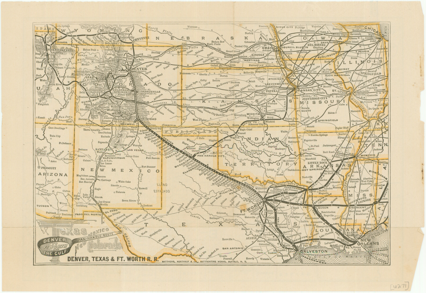
Denver to Ft. Worth and the Gulf. Panhandle Route
-
Map/Doc
76297
-
Collection
Texas State Library and Archives
-
Object Dates
[1888 ca.] (Creation Date)
-
People and Organizations
Denver, Texas and Ft. Worth Railway (Publisher)
Matthews, Northrup and Company (Printer)
-
Subjects
Railroads
-
Height x Width
7.5 x 10.9 inches
19.1 x 27.7 cm
-
Comments
Prints available courtesy of the Texas State Library and Archives.
More info can be found here: TSLAC Map 06271
Part of: Texas State Library and Archives
General Highway Map, Dimmit County, Zavala County, Texas

Print $20.00
General Highway Map, Dimmit County, Zavala County, Texas
1961
Size 18.2 x 24.6 inches
Map/Doc 79444
Mapa de los Estados Unidos de Méjico, Segun lo organizado y definido por las varias actas del Congreso de dicha Republica: y construido por las mejores autoridades

Print $20.00
Mapa de los Estados Unidos de Méjico, Segun lo organizado y definido por las varias actas del Congreso de dicha Republica: y construido por las mejores autoridades
1846
Size 30.8 x 42.4 inches
Map/Doc 79727
Traveller's Map of the State of Texas

Print $20.00
Traveller's Map of the State of Texas
1867
Size 42.5 x 41.1 inches
Map/Doc 76226
General Highway Map, Nacogdoches County, Texas

Print $20.00
General Highway Map, Nacogdoches County, Texas
1961
Size 19.3 x 25.0 inches
Map/Doc 79606
General Highway Map, Runnels County, Texas

Print $20.00
General Highway Map, Runnels County, Texas
1961
Size 24.6 x 18.2 inches
Map/Doc 79642
General Highway Map, Cottle County, Texas

Print $20.00
General Highway Map, Cottle County, Texas
1961
Size 18.1 x 24.6 inches
Map/Doc 79423
General Highway Map, Callahan County, Texas

Print $20.00
General Highway Map, Callahan County, Texas
1940
Size 25.3 x 18.4 inches
Map/Doc 79037
General Highway Map, Brown County, Texas

Print $20.00
General Highway Map, Brown County, Texas
1961
Size 24.8 x 18.2 inches
Map/Doc 79389
General Highway Map, Willacy County, Texas

Print $20.00
General Highway Map, Willacy County, Texas
1961
Size 18.2 x 24.7 inches
Map/Doc 79711
Official Railroad and County Map of Texas

Print $40.00
Official Railroad and County Map of Texas
1914
Size 45.8 x 48.6 inches
Map/Doc 76233
Karte von Texas entworfen nach den Vermessungen, welche in den Acten der General-Land-Office der Republic liegen bis zum Jahr 1839 von Richard S. Hunt & Jesse F. Randel

Print $20.00
Karte von Texas entworfen nach den Vermessungen, welche in den Acten der General-Land-Office der Republic liegen bis zum Jahr 1839 von Richard S. Hunt & Jesse F. Randel
1841
Size 19.6 x 14.6 inches
Map/Doc 79311
General Highway Map, Oldham County, Texas

Print $20.00
General Highway Map, Oldham County, Texas
1961
Size 24.5 x 18.1 inches
Map/Doc 79619
You may also like
Cochran County Working Sketch 4

Print $20.00
- Digital $50.00
Cochran County Working Sketch 4
1984
Size 37.7 x 24.8 inches
Map/Doc 68015
[Sketch for Mineral Application 1487 -Big Wichita River, Ernest R. Smith]
![65684, [Sketch for Mineral Application 1487 -Big Wichita River, Ernest R. Smith], General Map Collection](https://historictexasmaps.com/wmedia_w700/maps/65684.tif.jpg)
Print $40.00
- Digital $50.00
[Sketch for Mineral Application 1487 -Big Wichita River, Ernest R. Smith]
1918
Size 32.2 x 130.1 inches
Map/Doc 65684
Hood County Rolled Sketch 2

Print $20.00
- Digital $50.00
Hood County Rolled Sketch 2
1958
Size 18.0 x 27.4 inches
Map/Doc 6219
Lipscomb County, Texas

Print $20.00
- Digital $50.00
Lipscomb County, Texas
Size 13.7 x 15.0 inches
Map/Doc 91304
Houston County Working Sketch 6

Print $20.00
- Digital $50.00
Houston County Working Sketch 6
1933
Size 37.1 x 30.8 inches
Map/Doc 66236
Armstrong County Sketch File 8

Print $8.00
- Digital $50.00
Armstrong County Sketch File 8
Size 14.2 x 8.8 inches
Map/Doc 13705
Winkler County Working Sketch 2

Print $20.00
- Digital $50.00
Winkler County Working Sketch 2
1944
Size 36.9 x 29.9 inches
Map/Doc 72596
Jefferson County Working Sketch 23

Print $20.00
- Digital $50.00
Jefferson County Working Sketch 23
1970
Size 23.9 x 29.2 inches
Map/Doc 66566
Colorado County Working Sketch 31

Print $20.00
- Digital $50.00
Colorado County Working Sketch 31
1981
Size 9.9 x 19.5 inches
Map/Doc 68131
Baylor County Sketch File 12A

Print $8.00
- Digital $50.00
Baylor County Sketch File 12A
1900
Size 9.3 x 7.3 inches
Map/Doc 14148
Outer Continental Shelf Leasing Maps (Louisiana Offshore Operations)

Print $20.00
- Digital $50.00
Outer Continental Shelf Leasing Maps (Louisiana Offshore Operations)
1955
Size 23.3 x 15.5 inches
Map/Doc 76094
Cass County Working Sketch 3

Print $20.00
- Digital $50.00
Cass County Working Sketch 3
1936
Size 34.3 x 38.5 inches
Map/Doc 67906