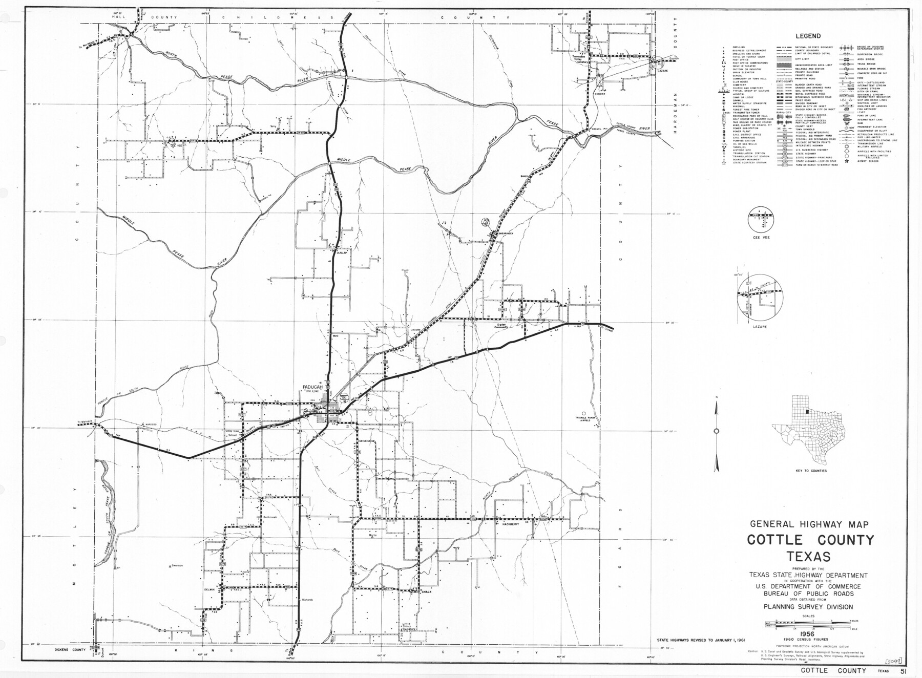
General Highway Map, Cottle County, Texas
-
Map/Doc
79423
-
Collection
Texas State Library and Archives
-
Object Dates
1961 (Creation Date)
-
People and Organizations
Texas State Highway Department (Publisher)
-
Counties
Cottle
-
Subjects
County
-
Height x Width
18.1 x 24.6 inches
46.0 x 62.5 cm
-
Comments
Prints available courtesy of the Texas State Library and Archives.
More info can be found here: TSLAC Map 05099
Part of: Texas State Library and Archives
General Highway Map, Chambers County, Texas

Print $20.00
General Highway Map, Chambers County, Texas
1961
Size 18.3 x 24.8 inches
Map/Doc 79404
General Highway Map. Detail of Cities and Towns in Galveston County, Texas [Galveston and vicinity]
![79097, General Highway Map. Detail of Cities and Towns in Galveston County, Texas [Galveston and vicinity], Texas State Library and Archives](https://historictexasmaps.com/wmedia_w700/maps/79097.tif.jpg)
Print $20.00
General Highway Map. Detail of Cities and Towns in Galveston County, Texas [Galveston and vicinity]
1939
Size 18.4 x 25.0 inches
Map/Doc 79097
General Highway Map, Young County, Texas

Print $20.00
General Highway Map, Young County, Texas
1940
Size 18.4 x 24.8 inches
Map/Doc 79286
General Highway Map, Stonewall County, Texas

Print $20.00
General Highway Map, Stonewall County, Texas
1961
Size 18.3 x 25.1 inches
Map/Doc 79662
General Highway Map. Detail of Cities and Towns in Jefferson County, Texas [Beaumont-Port Arthur vicinity]
![79145, General Highway Map. Detail of Cities and Towns in Jefferson County, Texas [Beaumont-Port Arthur vicinity], Texas State Library and Archives](https://historictexasmaps.com/wmedia_w700/maps/79145.tif.jpg)
Print $20.00
General Highway Map. Detail of Cities and Towns in Jefferson County, Texas [Beaumont-Port Arthur vicinity]
1940
Size 24.8 x 18.3 inches
Map/Doc 79145
General Highway Map, Henderson County, Texas

Print $20.00
General Highway Map, Henderson County, Texas
1961
Size 24.9 x 18.0 inches
Map/Doc 79517
General Highway Map, Hutchinson County, Texas

Print $20.00
General Highway Map, Hutchinson County, Texas
1961
Size 18.1 x 24.6 inches
Map/Doc 79529
Geological Petroleum Corporation Map of North Central Texas

Print $20.00
Geological Petroleum Corporation Map of North Central Texas
1920
Size 37.4 x 28.4 inches
Map/Doc 79305
Greater Fort Worth New City Map

Print $20.00
Greater Fort Worth New City Map
1925
Size 33.5 x 22.6 inches
Map/Doc 76286
General Highway Map. Detail of Cities and Towns in Travis County, Texas. City Map, Austin and vicinity, Travis County, Texas

Print $20.00
General Highway Map. Detail of Cities and Towns in Travis County, Texas. City Map, Austin and vicinity, Travis County, Texas
1961
Size 18.2 x 24.9 inches
Map/Doc 79684
General Highway Map, Jeff Davis County, Texas

Print $20.00
General Highway Map, Jeff Davis County, Texas
1961
Size 18.3 x 24.6 inches
Map/Doc 79536
General Highway Map, El Paso County, Texas

Print $20.00
General Highway Map, El Paso County, Texas
1961
Size 18.2 x 24.6 inches
Map/Doc 79459
You may also like
Grimes County Rolled Sketch 1

Print $20.00
- Digital $50.00
Grimes County Rolled Sketch 1
1945
Size 34.6 x 35.0 inches
Map/Doc 9007

Flight Mission No. CRE-2R, Frame 165, Jackson County

Print $20.00
- Digital $50.00
Flight Mission No. CRE-2R, Frame 165, Jackson County
1956
Size 18.5 x 22.3 inches
Map/Doc 85375
Harris County Working Sketch 60

Print $20.00
- Digital $50.00
Harris County Working Sketch 60
1953
Size 31.8 x 35.2 inches
Map/Doc 65952
Pecos County Rolled Sketch 146A

Print $37.00
- Digital $50.00
Pecos County Rolled Sketch 146A
1957
Size 10.4 x 15.2 inches
Map/Doc 48396
Montague County Working Sketch 11

Print $20.00
- Digital $50.00
Montague County Working Sketch 11
1936
Size 33.8 x 21.3 inches
Map/Doc 71077
Potter County Sketch File 23

Print $4.00
- Digital $50.00
Potter County Sketch File 23
Size 11.1 x 8.7 inches
Map/Doc 34421
[Sketch N, showing Blocks C-10, C-14 through C-16]
![91772, [Sketch N, showing Blocks C-10, C-14 through C-16], Twichell Survey Records](https://historictexasmaps.com/wmedia_w700/maps/91772-1.tif.jpg)
Print $20.00
- Digital $50.00
[Sketch N, showing Blocks C-10, C-14 through C-16]
Size 38.6 x 22.1 inches
Map/Doc 91772
Jefferson County NRC Article 33.136 Sketch 8

Print $20.00
- Digital $50.00
Jefferson County NRC Article 33.136 Sketch 8
2007
Size 20.1 x 18.7 inches
Map/Doc 87503
Real County Sketch File 5

Print $20.00
- Digital $50.00
Real County Sketch File 5
Size 16.9 x 20.9 inches
Map/Doc 12228
Pecos County Sketch File 27c

Print $4.00
- Digital $50.00
Pecos County Sketch File 27c
Size 11.1 x 9.1 inches
Map/Doc 33681
Colorado County Sketch File 9

Print $3.00
- Digital $50.00
Colorado County Sketch File 9
Size 11.3 x 17.0 inches
Map/Doc 11134