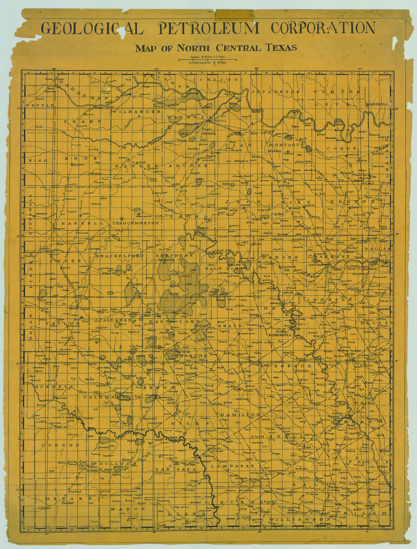
Geological Petroleum Corporation Map of North Central Texas
-
Map/Doc
79305
-
Collection
Texas State Library and Archives
-
Object Dates
[1920 ca.] (Creation Date)
-
Subjects
Energy Surface State of Texas
-
Height x Width
37.4 x 28.4 inches
95.0 x 72.1 cm
-
Comments
Prints available courtesy of the Texas State Library and Archives.
More info can be found here: TSLAC Map 04243
Part of: Texas State Library and Archives
General Highway Map, Galveston County, Texas

Print $20.00
General Highway Map, Galveston County, Texas
1961
Size 18.2 x 24.6 inches
Map/Doc 79476
General Highway Map, Hudspeth County, Texas

Print $20.00
General Highway Map, Hudspeth County, Texas
1961
Size 25.1 x 18.2 inches
Map/Doc 79527
General Highway Map, Red River County, Texas

Print $20.00
General Highway Map, Red River County, Texas
1940
Size 25.0 x 18.3 inches
Map/Doc 79226
General Highway Map, Bandera County, Texas

Print $20.00
General Highway Map, Bandera County, Texas
1940
Size 18.4 x 25.1 inches
Map/Doc 79011
General Highway Map, Carson County, Texas

Print $20.00
General Highway Map, Carson County, Texas
1940
Size 18.5 x 25.1 inches
Map/Doc 79041
General Highway Map, Jack County, Texas

Print $20.00
General Highway Map, Jack County, Texas
1961
Size 18.2 x 24.5 inches
Map/Doc 79532
General Highway Map, Swisher County, Texas

Print $20.00
General Highway Map, Swisher County, Texas
1940
Size 18.4 x 25.0 inches
Map/Doc 79250
General Highway Map, Briscoe County, Texas

Print $20.00
General Highway Map, Briscoe County, Texas
1940
Size 18.5 x 24.9 inches
Map/Doc 79029
General Highway Map, Angelina County, Texas

Print $20.00
General Highway Map, Angelina County, Texas
1961
Size 25.1 x 18.4 inches
Map/Doc 79350
General Highway Map, Palo Pinto County, Texas

Print $20.00
General Highway Map, Palo Pinto County, Texas
1940
Size 18.2 x 24.6 inches
Map/Doc 79213
Reconnaissance of Aransas Pass, Texas

Print $20.00
Reconnaissance of Aransas Pass, Texas
1853
Size 14.9 x 12.4 inches
Map/Doc 76250
General Highway Map, Callahan County, Texas

Print $20.00
General Highway Map, Callahan County, Texas
1961
Size 25.0 x 18.2 inches
Map/Doc 79396
You may also like
Colorado River, Bonus Sheet

Print $6.00
- Digital $50.00
Colorado River, Bonus Sheet
1941
Size 24.2 x 30.4 inches
Map/Doc 65307
[Right of Way Map, Belton Branch of the M.K.&T. RR.]
![64229, [Right of Way Map, Belton Branch of the M.K.&T. RR.], General Map Collection](https://historictexasmaps.com/wmedia_w700/maps/64229.tif.jpg)
Print $20.00
- Digital $50.00
[Right of Way Map, Belton Branch of the M.K.&T. RR.]
1896
Size 22.1 x 7.3 inches
Map/Doc 64229

Old Miscellaneous File 27

Print $28.00
- Digital $50.00
Old Miscellaneous File 27
1879
Size 14.4 x 8.8 inches
Map/Doc 75636
Flight Mission No. DCL-4C, Frame 123, Kenedy County

Print $20.00
- Digital $50.00
Flight Mission No. DCL-4C, Frame 123, Kenedy County
1943
Size 18.6 x 22.3 inches
Map/Doc 85822
Freestone County Working Sketch 2

Print $20.00
- Digital $50.00
Freestone County Working Sketch 2
1913
Size 23.1 x 28.2 inches
Map/Doc 69244
Flight Mission No. DCL-4C, Frame 65, Kenedy County

Print $20.00
- Digital $50.00
Flight Mission No. DCL-4C, Frame 65, Kenedy County
1943
Size 18.5 x 22.3 inches
Map/Doc 85810
Flight Mission No. CRC-3R, Frame 166, Chambers County

Print $20.00
- Digital $50.00
Flight Mission No. CRC-3R, Frame 166, Chambers County
1956
Size 18.8 x 22.4 inches
Map/Doc 84848
Webb County Working Sketch 46

Print $20.00
- Digital $50.00
Webb County Working Sketch 46
1947
Size 18.4 x 23.5 inches
Map/Doc 72411
Calhoun County Working Sketch 12

Print $20.00
- Digital $50.00
Calhoun County Working Sketch 12
1976
Size 35.2 x 47.7 inches
Map/Doc 67828
Flight Mission No. CGI-1N, Frame 178, Cameron County

Print $20.00
- Digital $50.00
Flight Mission No. CGI-1N, Frame 178, Cameron County
1955
Size 18.6 x 22.3 inches
Map/Doc 84513
Hemphill County Working Sketch 23

Print $40.00
- Digital $50.00
Hemphill County Working Sketch 23
1973
Size 36.4 x 59.6 inches
Map/Doc 66118