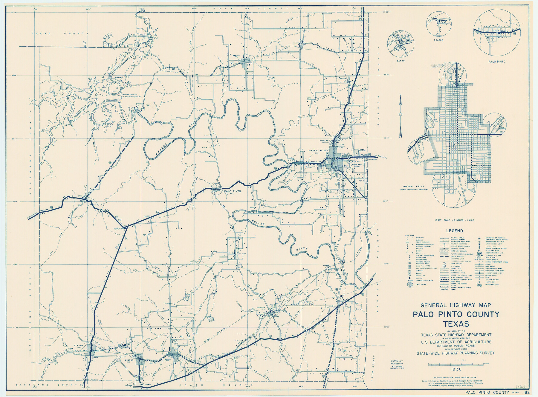
General Highway Map, Palo Pinto County, Texas
-
Map/Doc
79213
-
Collection
Texas State Library and Archives
-
Object Dates
1940 (Creation Date)
-
People and Organizations
Texas State Highway Department (Publisher)
-
Counties
Palo Pinto
-
Subjects
County
-
Height x Width
18.2 x 24.6 inches
46.2 x 62.5 cm
-
Comments
Prints available courtesy of the Texas State Library and Archives.
More info can be found here: TSLAC Map 04965
Part of: Texas State Library and Archives
General Highway Map, Erath County, Texas

Print $20.00
General Highway Map, Erath County, Texas
1961
Size 24.6 x 18.2 inches
Map/Doc 79460
General Highway Map, Atascosa County, Texas

Print $20.00
General Highway Map, Atascosa County, Texas
1940
Size 18.5 x 25.0 inches
Map/Doc 79007

General Highway Map, Angelina County, Texas

Print $20.00
General Highway Map, Angelina County, Texas
1940
Size 18.5 x 24.9 inches
Map/Doc 79003
General Highway Map, Sabine County, Texas

Print $20.00
General Highway Map, Sabine County, Texas
1940
Size 24.9 x 18.4 inches
Map/Doc 79234
General Highway Map, Caldwell County, Texas

Print $20.00
General Highway Map, Caldwell County, Texas
1940
Size 18.5 x 25.2 inches
Map/Doc 79034
Reconnoissance of Sabine Pass

Print $20.00
Reconnoissance of Sabine Pass
1853
Size 12.4 x 10.3 inches
Map/Doc 76281
General Highway Map, Chambers County, Texas

Print $20.00
General Highway Map, Chambers County, Texas
1940
Size 18.4 x 25.3 inches
Map/Doc 79044
General Highway Map. Detail of Cities and Towns in Dallas County, Texas [Dallas and vicinity]
![79435, General Highway Map. Detail of Cities and Towns in Dallas County, Texas [Dallas and vicinity], Texas State Library and Archives](https://historictexasmaps.com/wmedia_w700/maps/79435.tif.jpg)
Print $20.00
General Highway Map. Detail of Cities and Towns in Dallas County, Texas [Dallas and vicinity]
1961
Size 18.2 x 24.6 inches
Map/Doc 79435
General Highway Map, Hartley County, Texas

Print $20.00
General Highway Map, Hartley County, Texas
1961
Size 24.8 x 18.2 inches
Map/Doc 79510
General Highway Map, Armstrong County, Texas

Print $20.00
General Highway Map, Armstrong County, Texas
1961
Size 18.3 x 25.0 inches
Map/Doc 79354
General Highway Map, Midland County, Texas

Print $20.00
General Highway Map, Midland County, Texas
1961
Size 18.2 x 24.6 inches
Map/Doc 79596
You may also like
Kleberg County Rolled Sketch 10-40

Print $20.00
- Digital $50.00
Kleberg County Rolled Sketch 10-40
1952
Size 38.1 x 34.0 inches
Map/Doc 9392
Kinney County Working Sketch 42

Print $20.00
- Digital $50.00
Kinney County Working Sketch 42
1973
Size 20.4 x 33.7 inches
Map/Doc 70224
Tom Green County Boundary File 4

Print $70.00
- Digital $50.00
Tom Green County Boundary File 4
Size 8.8 x 6.8 inches
Map/Doc 59347
Upton County Working Sketch 60

Print $20.00
- Digital $50.00
Upton County Working Sketch 60
2012
Size 34.2 x 32.1 inches
Map/Doc 93387
Terrell County Working Sketch 44

Print $40.00
- Digital $50.00
Terrell County Working Sketch 44
1957
Size 40.0 x 71.4 inches
Map/Doc 62137
[West Half of the State of Kansas]
![93159, [West Half of the State of Kansas], Twichell Survey Records](https://historictexasmaps.com/wmedia_w700/maps/93159-1.tif.jpg)
Print $40.00
- Digital $50.00
[West Half of the State of Kansas]
Size 60.8 x 54.0 inches
Map/Doc 93159
[Southeast part of County]
![89956, [Southeast part of County], Twichell Survey Records](https://historictexasmaps.com/wmedia_w700/maps/89956-2.tif.jpg)
Print $40.00
- Digital $50.00
[Southeast part of County]
Size 37.1 x 48.2 inches
Map/Doc 89956
San Patricio County Sketch File 43

Print $68.00
- Digital $50.00
San Patricio County Sketch File 43
1980
Size 11.3 x 8.9 inches
Map/Doc 36251
General Highway Map, Presidio County, Texas

Print $20.00
General Highway Map, Presidio County, Texas
1940
Size 24.6 x 18.3 inches
Map/Doc 79222
Guadalupe County Working Sketch 6

Print $20.00
- Digital $50.00
Guadalupe County Working Sketch 6
1948
Size 24.0 x 19.7 inches
Map/Doc 63315
Nueces County Sketch File 21

Print $8.00
- Digital $50.00
Nueces County Sketch File 21
1880
Size 5.9 x 5.5 inches
Map/Doc 32557
Harrison County Rolled Sketch 4

Print $20.00
- Digital $50.00
Harrison County Rolled Sketch 4
1938
Size 28.2 x 34.9 inches
Map/Doc 6150