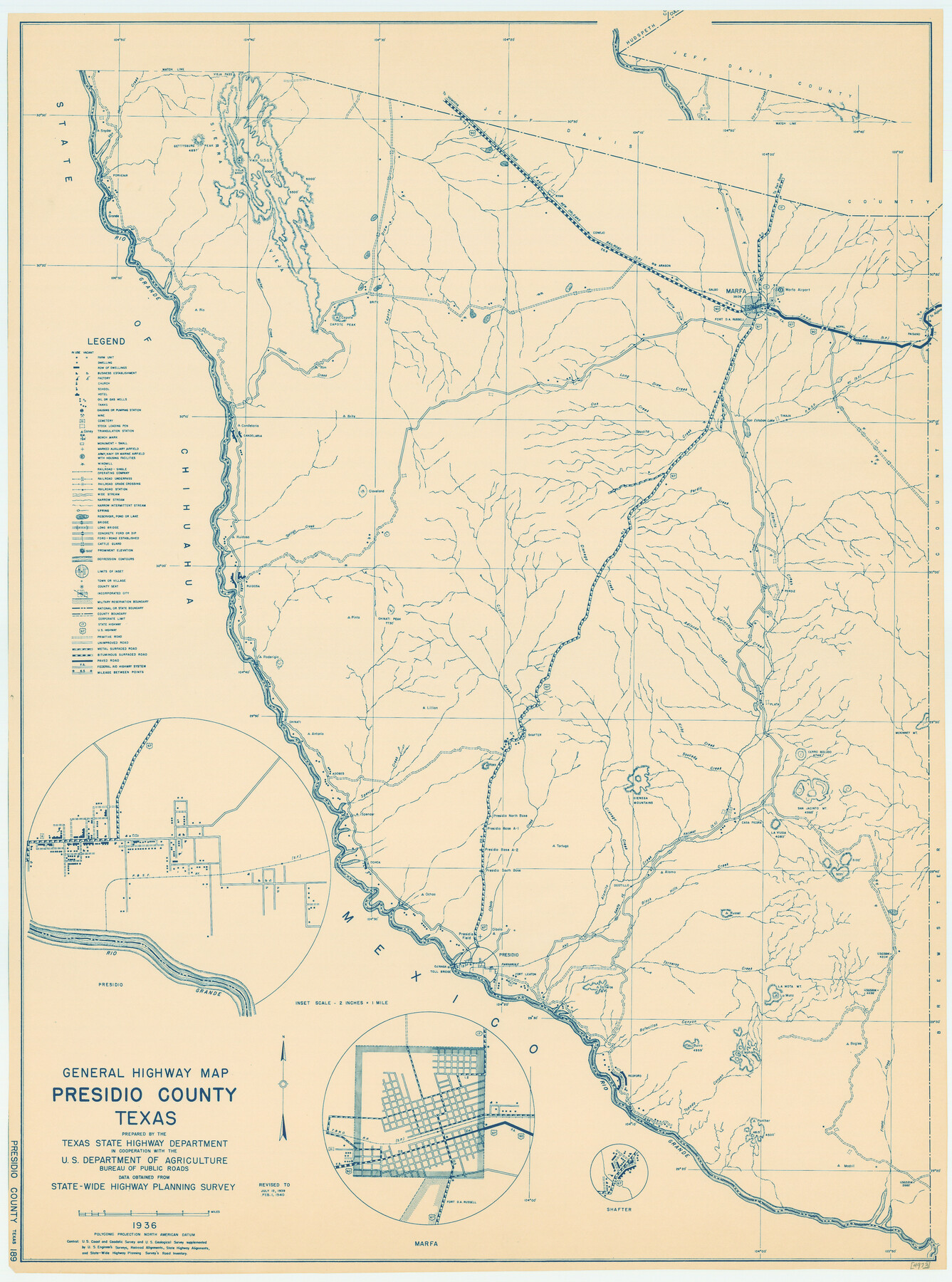
General Highway Map, Presidio County, Texas
-
Map/Doc
79222
-
Collection
Texas State Library and Archives
-
Object Dates
1940 (Creation Date)
-
People and Organizations
Texas State Highway Department (Publisher)
-
Counties
Presidio
-
Subjects
County
-
Height x Width
24.6 x 18.3 inches
62.5 x 46.5 cm
-
Comments
Prints available courtesy of the Texas State Library and Archives.
More info can be found here: TSLAC Map 04973
Part of: Texas State Library and Archives
General Highway Map. Detail of Cities and Towns in Bexar County, Texas [San Antonio and vicinity]
![79018, General Highway Map. Detail of Cities and Towns in Bexar County, Texas [San Antonio and vicinity], Texas State Library and Archives](https://historictexasmaps.com/wmedia_w700/maps/79018.tif.jpg)
Print $20.00
General Highway Map. Detail of Cities and Towns in Bexar County, Texas [San Antonio and vicinity]
1940
Size 18.6 x 25.2 inches
Map/Doc 79018
General Highway Map, Hardin County, Texas

Print $20.00
General Highway Map, Hardin County, Texas
1940
Size 18.4 x 24.8 inches
Map/Doc 79114
General Highway Map, Tom Green County, Texas

Print $20.00
General Highway Map, Tom Green County, Texas
1961
Size 25.0 x 18.1 inches
Map/Doc 79677
General Highway Map, Terrell County, Texas

Print $20.00
General Highway Map, Terrell County, Texas
1961
Size 24.9 x 18.2 inches
Map/Doc 79674


Official Highway Map of Texas

Print $20.00
Official Highway Map of Texas
1926
Size 25.0 x 24.9 inches
Map/Doc 79744
General Highway Map, Jackson County, Texas

Print $20.00
General Highway Map, Jackson County, Texas
1961
Size 18.2 x 24.7 inches
Map/Doc 79533
General Highway Map, Zapata County, Texas

Print $20.00
General Highway Map, Zapata County, Texas
1940
Size 18.3 x 24.9 inches
Map/Doc 79288
General Highway Map, Angelina County, Texas

Print $20.00
General Highway Map, Angelina County, Texas
1961
Size 25.1 x 18.1 inches
Map/Doc 79349
General Highway Map, Tom Green County, Texas

Print $20.00
General Highway Map, Tom Green County, Texas
1940
Size 24.9 x 18.3 inches
Map/Doc 79259
General Highway Map. Detail of Cities and Towns in Cherokee County, Texas [Jacksonville, Rusk, Alto, Wells, and vicinities of these cities]
![79407, General Highway Map. Detail of Cities and Towns in Cherokee County, Texas [Jacksonville, Rusk, Alto, Wells, and vicinities of these cities], Texas State Library and Archives](https://historictexasmaps.com/wmedia_w700/maps/79407.tif.jpg)
Print $20.00
General Highway Map. Detail of Cities and Towns in Cherokee County, Texas [Jacksonville, Rusk, Alto, Wells, and vicinities of these cities]
1961
Size 18.2 x 24.9 inches
Map/Doc 79407
You may also like
Sabine County Working Sketch 1

Print $20.00
- Digital $50.00
Sabine County Working Sketch 1
1922
Size 17.7 x 17.7 inches
Map/Doc 63672
Yoakum County Sketch File 8

Print $20.00
- Digital $50.00
Yoakum County Sketch File 8
Size 25.6 x 29.3 inches
Map/Doc 12705
Upton County Working Sketch 56

Print $20.00
- Digital $50.00
Upton County Working Sketch 56
1985
Size 43.9 x 43.8 inches
Map/Doc 69553
[T. & G. Ry. Main Line, Texas, Right of Way Map, Center to Gary]
![64568, [T. & G. Ry. Main Line, Texas, Right of Way Map, Center to Gary], General Map Collection](https://historictexasmaps.com/wmedia_w700/maps/64568-1.tif.jpg)
Print $40.00
- Digital $50.00
[T. & G. Ry. Main Line, Texas, Right of Way Map, Center to Gary]
1917
Size 31.0 x 121.2 inches
Map/Doc 64568
Haskell County Sketch File 1

Print $20.00
- Digital $50.00
Haskell County Sketch File 1
1856
Size 19.9 x 10.6 inches
Map/Doc 11738
Orange County Sketch File 28

Print $4.00
- Digital $50.00
Orange County Sketch File 28
1922
Size 11.3 x 8.7 inches
Map/Doc 33356
Cass County Working Sketch 5

Print $20.00
- Digital $50.00
Cass County Working Sketch 5
1936
Size 45.6 x 43.1 inches
Map/Doc 67908
Magnetic Declination in the United States - Epoch 1980

Print $20.00
- Digital $50.00
Magnetic Declination in the United States - Epoch 1980
1980
Size 41.4 x 33.3 inches
Map/Doc 92368
Coleman County Sketch File 50

Print $4.00
- Digital $50.00
Coleman County Sketch File 50
Size 12.6 x 8.2 inches
Map/Doc 18853
Morris County Rolled Sketch 2A

Print $20.00
- Digital $50.00
Morris County Rolled Sketch 2A
Size 36.2 x 19.3 inches
Map/Doc 10282
[Sketch for Mineral Application 27670 - Strip between Simon Sanchez leagues and Trinity River]
![2866, [Sketch for Mineral Application 27670 - Strip between Simon Sanchez leagues and Trinity River], General Map Collection](https://historictexasmaps.com/wmedia_w700/maps/2866-1.tif.jpg)
Print $20.00
- Digital $50.00
[Sketch for Mineral Application 27670 - Strip between Simon Sanchez leagues and Trinity River]
1934
Size 17.3 x 36.7 inches
Map/Doc 2866
Map of Surveys Made for the T&PRR in Martin & Tom Green Counties, Blocks 34-39, Reserve West of the Colorado River

Print $20.00
- Digital $50.00
Map of Surveys Made for the T&PRR in Martin & Tom Green Counties, Blocks 34-39, Reserve West of the Colorado River
1876
Size 41.9 x 43.7 inches
Map/Doc 2226