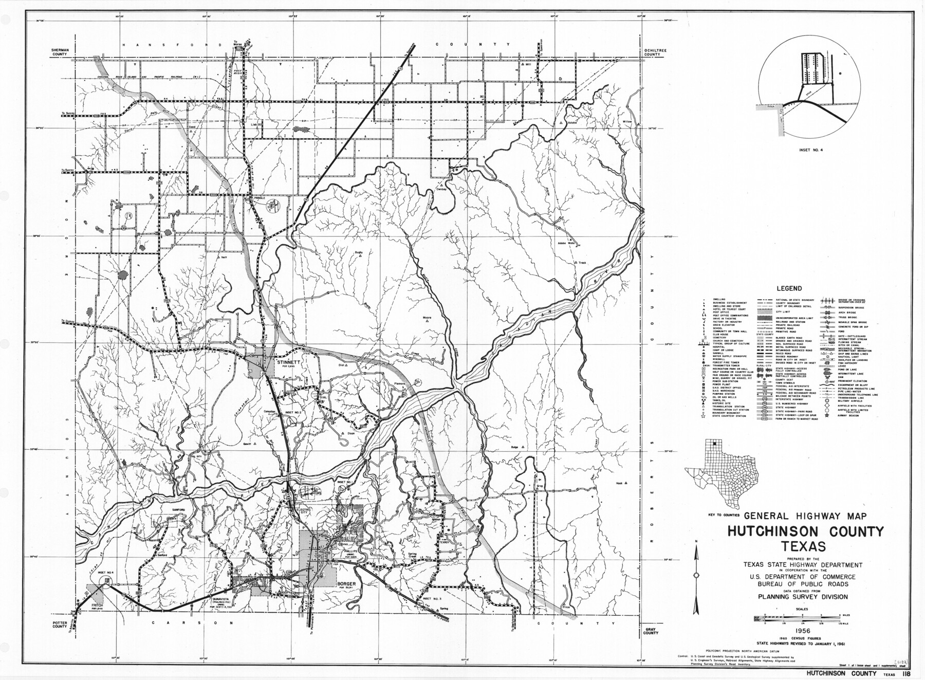
General Highway Map, Hutchinson County, Texas
-
Map/Doc
79529
-
Collection
Texas State Library and Archives
-
Object Dates
1961 (Creation Date)
-
People and Organizations
Texas State Highway Department (Publisher)
-
Counties
Hutchinson
-
Subjects
County
-
Height x Width
18.1 x 24.6 inches
46.0 x 62.5 cm
-
Comments
Prints available courtesy of the Texas State Library and Archives.
More info can be found here: TSLAC Map 05182
Part of: Texas State Library and Archives
Oil and Gas Fields in the State of Texas

Print $40.00
Oil and Gas Fields in the State of Texas
1927
Size 58.0 x 38.0 inches
Map/Doc 76304
General Highway Map, Bexar County, Texas

Print $20.00
General Highway Map, Bexar County, Texas
1961
Size 18.4 x 25.0 inches
Map/Doc 79370
General Highway Map, Hays County, Texas

Print $20.00
General Highway Map, Hays County, Texas
1961
Size 18.1 x 24.7 inches
Map/Doc 79513
General Highway Map, Motley County, Texas

Print $20.00
General Highway Map, Motley County, Texas
1961
Size 24.7 x 18.1 inches
Map/Doc 79605
General Highway Map, Hutchinson County, Texas

Print $20.00
General Highway Map, Hutchinson County, Texas
1940
Size 18.3 x 24.8 inches
Map/Doc 79137
General Highway Map, Dallas County, Rockwall County, Texas

Print $20.00
General Highway Map, Dallas County, Rockwall County, Texas
1936
Size 18.7 x 25.2 inches
Map/Doc 79066
Map of Texas and Parts of Adjoining Territories

Print $20.00
Map of Texas and Parts of Adjoining Territories
1899
Size 33.7 x 36.0 inches
Map/Doc 79304
General Highway Map, Kimble County, Texas

Print $20.00
General Highway Map, Kimble County, Texas
1940
Size 24.9 x 18.3 inches
Map/Doc 79159
General Highway Map, Borden County, Texas

Print $20.00
General Highway Map, Borden County, Texas
1940
Size 18.5 x 25.0 inches
Map/Doc 79021
A Map of the Internal Provinces of New Spain

Print $20.00
A Map of the Internal Provinces of New Spain
1807
Size 18.9 x 19.5 inches
Map/Doc 76234
General Highway Map, Comanche County, Texas

Print $20.00
General Highway Map, Comanche County, Texas
1961
Size 24.7 x 18.2 inches
Map/Doc 79419
Map of the Country Upon Upper Red River Explored in 1852

Print $20.00
Map of the Country Upon Upper Red River Explored in 1852
1852
Size 17.2 x 34.9 inches
Map/Doc 79726
You may also like
Baylor County Sketch File 19

Print $4.00
- Digital $50.00
Baylor County Sketch File 19
1885
Size 11.5 x 8.8 inches
Map/Doc 14193
Duval County Rolled Sketch 15

Print $20.00
- Digital $50.00
Duval County Rolled Sketch 15
1940
Size 38.7 x 27.1 inches
Map/Doc 5737
Coke County Rolled Sketch 2

Print $20.00
- Digital $50.00
Coke County Rolled Sketch 2
1947
Size 15.5 x 17.4 inches
Map/Doc 5504
Donley County Sketch File 27

Print $4.00
- Digital $50.00
Donley County Sketch File 27
Size 7.7 x 12.1 inches
Map/Doc 21264
Atascosa County Rolled Sketch 10

Print $40.00
- Digital $50.00
Atascosa County Rolled Sketch 10
1943
Size 36.0 x 77.6 inches
Map/Doc 8428
[Right of Way & Track Map, The Texas & Pacific Ry. Co. Main Line]
![64673, [Right of Way & Track Map, The Texas & Pacific Ry. Co. Main Line], General Map Collection](https://historictexasmaps.com/wmedia_w700/maps/64673.tif.jpg)
Print $20.00
- Digital $50.00
[Right of Way & Track Map, The Texas & Pacific Ry. Co. Main Line]
Size 11.2 x 18.6 inches
Map/Doc 64673
[Sketch highlighting Bob Reid and Fred Turner surveys]
![91692, [Sketch highlighting Bob Reid and Fred Turner surveys], Twichell Survey Records](https://historictexasmaps.com/wmedia_w700/maps/91692-1.tif.jpg)
Print $2.00
- Digital $50.00
[Sketch highlighting Bob Reid and Fred Turner surveys]
Size 5.9 x 7.6 inches
Map/Doc 91692
El Paso County Sketch File 35 (6)

Print $20.00
- Digital $50.00
El Paso County Sketch File 35 (6)
1886
Size 20.3 x 36.9 inches
Map/Doc 11460
Houston Ship Channel, Atkinson Island to Alexander Island

Print $40.00
- Digital $50.00
Houston Ship Channel, Atkinson Island to Alexander Island
1973
Size 36.7 x 50.2 inches
Map/Doc 69902
Stonewall County Working Sketch 13

Print $20.00
- Digital $50.00
Stonewall County Working Sketch 13
1951
Size 31.9 x 33.7 inches
Map/Doc 62320
Travis County Boundary File 31

Print $4.00
- Digital $50.00
Travis County Boundary File 31
Size 10.0 x 8.2 inches
Map/Doc 59471
Carta Esferica Del Reyno De Mexico y parte de la America Setentrional, Para inteligencia de la Obra intitulada: Descubrimiento y Conquista de la America

Print $20.00
- Digital $50.00
Carta Esferica Del Reyno De Mexico y parte de la America Setentrional, Para inteligencia de la Obra intitulada: Descubrimiento y Conquista de la America
1802
Size 15.1 x 20.5 inches
Map/Doc 97410