Hood County Rolled Sketch 2
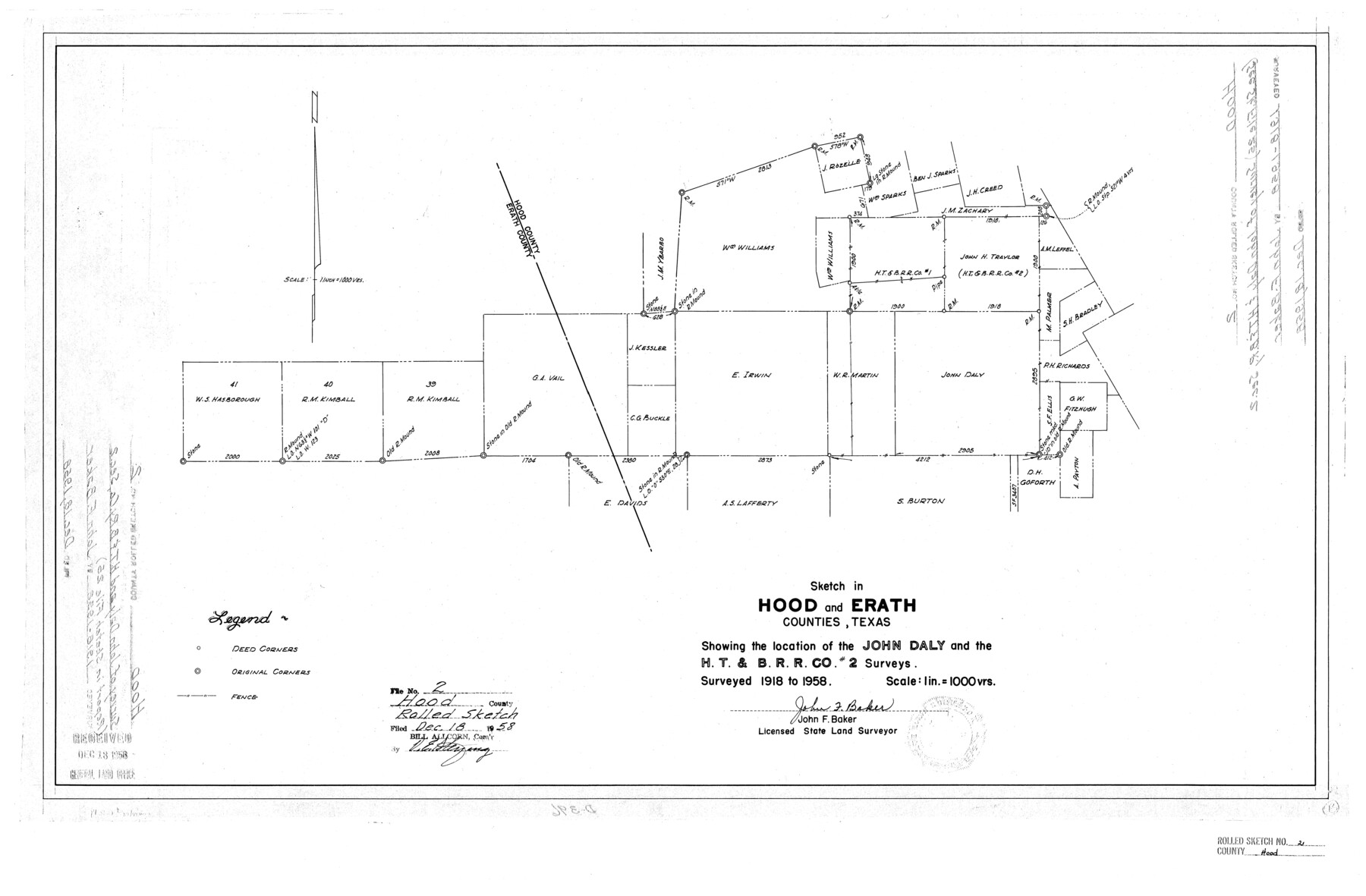
Sketch in Hood and Erath Counties, Texas showing the location of the John Daly and the H. T. & B. R.R. Co. #2 surveys
-
Map/Doc
6219
-
Collection
General Map Collection
-
Object Dates
1958 (Creation Date)
1918-1958 (Survey Date)
12/18/1958 (File Date)
-
People and Organizations
John F. Baker (Surveyor/Engineer)
-
Counties
Hood Erath
-
Subjects
Surveying Rolled Sketch
-
Height x Width
18.0 x 27.4 inches
45.7 x 69.6 cm
-
Scale
1" = 1000 varas
Part of: General Map Collection
[Map of the Stockdale-Cuero Extension G.H. & S.A. Ry.]
![64096, [Map of the Stockdale-Cuero Extension G.H. & S.A. Ry.], General Map Collection](https://historictexasmaps.com/wmedia_w700/maps/64096.tif.jpg)
Print $40.00
- Digital $50.00
[Map of the Stockdale-Cuero Extension G.H. & S.A. Ry.]
1905
Size 19.4 x 118.2 inches
Map/Doc 64096
San Patricio County Rolled Sketch 4

Print $20.00
- Digital $50.00
San Patricio County Rolled Sketch 4
1875
Size 18.4 x 28.8 inches
Map/Doc 7572
Cass County Rolled Sketch 5A

Print $20.00
- Digital $50.00
Cass County Rolled Sketch 5A
Size 15.4 x 18.0 inches
Map/Doc 5411
Hudspeth County Working Sketch 60

Print $20.00
- Digital $50.00
Hudspeth County Working Sketch 60
1992
Size 36.1 x 33.6 inches
Map/Doc 66345
Jeff Davis County Sketch File 9

Print $40.00
- Digital $50.00
Jeff Davis County Sketch File 9
Size 15.1 x 17.6 inches
Map/Doc 27920
Coke County Rolled Sketch 1

Print $20.00
- Digital $50.00
Coke County Rolled Sketch 1
1943
Size 26.9 x 21.6 inches
Map/Doc 5503
Houston County Sketch File 24a

Print $20.00
- Digital $50.00
Houston County Sketch File 24a
1873
Size 26.3 x 21.0 inches
Map/Doc 11787
Crockett County Sketch File KL

Print $20.00
- Digital $50.00
Crockett County Sketch File KL
1925
Size 30.0 x 28.7 inches
Map/Doc 11243
Hutchinson County Rolled Sketch 36B

Print $20.00
- Digital $50.00
Hutchinson County Rolled Sketch 36B
1888
Size 21.1 x 25.3 inches
Map/Doc 6295
Outer Continental Shelf Leasing Maps (Louisiana Offshore Operations)

Print $20.00
- Digital $50.00
Outer Continental Shelf Leasing Maps (Louisiana Offshore Operations)
1954
Size 18.2 x 16.0 inches
Map/Doc 76105
Wilson County Working Sketch 13

Print $40.00
- Digital $50.00
Wilson County Working Sketch 13
1985
Size 23.9 x 53.5 inches
Map/Doc 72593
Burnet County Sketch File 44

Print $10.00
- Digital $50.00
Burnet County Sketch File 44
1936
Size 11.3 x 8.8 inches
Map/Doc 16767
You may also like
Map of the Country upon the Brazos and Big Witchita Rivers Explored in 1854 by Capt. R.B. Marcy 5th U.S. Infy. Embracing the Lands appropriated by the State of Texas for the Use of the Indians

Print $20.00
- Digital $50.00
Map of the Country upon the Brazos and Big Witchita Rivers Explored in 1854 by Capt. R.B. Marcy 5th U.S. Infy. Embracing the Lands appropriated by the State of Texas for the Use of the Indians
Size 29.6 x 33.8 inches
Map/Doc 93999
[Township 3 North, Block 32]
![91210, [Township 3 North, Block 32], Twichell Survey Records](https://historictexasmaps.com/wmedia_w700/maps/91210-1.tif.jpg)
Print $20.00
- Digital $50.00
[Township 3 North, Block 32]
Size 14.5 x 13.2 inches
Map/Doc 91210
Flight Mission No. DQN-1K, Frame 122, Calhoun County

Print $20.00
- Digital $50.00
Flight Mission No. DQN-1K, Frame 122, Calhoun County
1953
Size 18.5 x 22.2 inches
Map/Doc 84188
Panola County Working Sketch 5

Print $20.00
- Digital $50.00
Panola County Working Sketch 5
1940
Map/Doc 71414
Kent County Working Sketch 22

Print $20.00
- Digital $50.00
Kent County Working Sketch 22
1987
Size 42.7 x 43.1 inches
Map/Doc 70029
Working Sketch in Moore County

Print $3.00
- Digital $50.00
Working Sketch in Moore County
1910
Size 15.0 x 10.0 inches
Map/Doc 91537
Frio County Working Sketch 27

Print $20.00
- Digital $50.00
Frio County Working Sketch 27
Size 25.3 x 36.8 inches
Map/Doc 78193
Brewster County Sketch File 40

Print $6.00
- Digital $50.00
Brewster County Sketch File 40
1910
Size 15.2 x 10.3 inches
Map/Doc 16302
The United States of America

Print $20.00
- Digital $50.00
The United States of America
1866
Size 22.4 x 18.2 inches
Map/Doc 72645
[Lgs. 209-212, 182, 183, 195-200 with notes]
![90159, [Lgs. 209-212, 182, 183, 195-200 with notes], Twichell Survey Records](https://historictexasmaps.com/wmedia_w700/maps/90159-1.tif.jpg)
Print $20.00
- Digital $50.00
[Lgs. 209-212, 182, 183, 195-200 with notes]
Size 18.7 x 15.6 inches
Map/Doc 90159
Panola County Sketch File 11

Print $6.00
- Digital $50.00
Panola County Sketch File 11
1872
Size 10.3 x 13.2 inches
Map/Doc 33467
Potter County Rolled Sketch 11

Print $20.00
- Digital $50.00
Potter County Rolled Sketch 11
1986
Size 21.6 x 27.4 inches
Map/Doc 7324