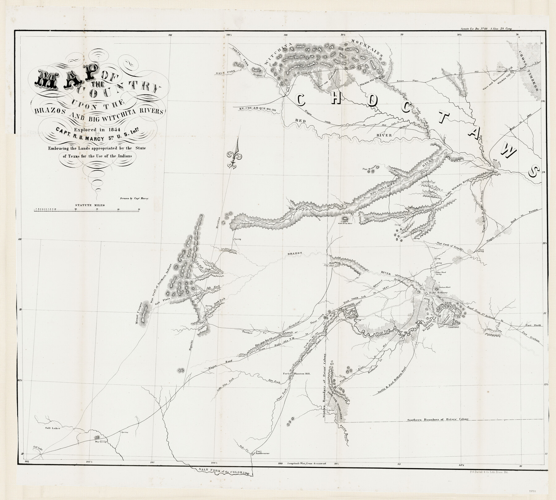
Map of the Country upon the Brazos and Big Witchita Rivers Explored in 1854 by Capt. R.B. Marcy 5th U.S. Infy. Embracing the Lands appropriated by the State of Texas for the Use of the Indians
-
Map/Doc
93999
-
Collection
General Map Collection
-
Object Dates
1854
-
People and Organizations
P.S. Duval & Co. Lith. Press (Printer)
R.B. Marcy (Draftsman)
-
Subjects
Military
-
Height x Width
29.6 x 33.8 inches
75.2 x 85.9 cm
-
Medium
paper
-
Features
South Fork of the Brazos River
Fort Belknap Road
Austin Road
Austin & Fort Belknap Road
Kechi Creek
Tock an ho no
Paint Creek
Qua qua ho no Creek
Qua qua ho no or Paint Creek
Mount Cooper
Hubbard's Creek
Panther Creek
Spring Creek
Stems Farm
Comanche Reservation
Clear Fork of the Brazos River
Kickapoo Old Village
Cadd [sic] Trail
Caddo's Reservation
Fort Chadbourne
Kecheahquehono River
Wagon Route in 1851
Wagon Road
Salt Plain
Sibley's Creek
Salt Fork of the Colorado River
Southern Boundary of Peter's Colony
Pecan Bayou
Salt Creek
Oak Creek
Big Spring
Salt Lakes
Salt Lake
Little Elm Fork [of the Brazos River]
Elm Fork [of the Brazos River]
Fort Phantom Hill
Western Boundary of Peter's Colony
Red River
Pecan Creek
Big Wichita River
Flat Mounds
Large Spring
Copper Creek
Beaver Creek
Rout [sic] in 1831
Cashe Creek
Sink Creek
Little Wichita River
Kecheahquehono or Red River
Otter Creek
Wichita Village
Waco & Towocoonee Village
Rush Creek
Return wagon route in 1852
Wichita Mountains
Salt Fork of the Red River
Salt Fork [of the Brazos River]
Salt Spring
Road from Fort Balknap to Fort Graham
Road from Fort Belknap to Fort Worth
Fort Belknap
Indian Knob
Cotton Wood Spring
Ketumsee Creek
Flat Rock Creek
North Fork of the Red River
Cat Fish Fork [of the Brazos River]
War trail of Northern Indians
Brazos River
Copper & Iron Ore
Rock Spring
West Fork of Trinity River
Wagon Road to Preston
Wagon Road to Fort Arbuckle
Part of: General Map Collection
Floyd County Sketch File 15

Print $12.00
- Digital $50.00
Floyd County Sketch File 15
1913
Size 10.9 x 7.3 inches
Map/Doc 22736
Hardeman County Working Sketch 5

Print $20.00
- Digital $50.00
Hardeman County Working Sketch 5
Size 23.0 x 35.7 inches
Map/Doc 63386
Terrell County Working Sketch 29

Print $20.00
- Digital $50.00
Terrell County Working Sketch 29
1944
Size 28.6 x 35.5 inches
Map/Doc 62121
Map of the Property traversed by the Trinity & Sabine Railroad from Fortieth Mile to Ogden, Texas

Print $40.00
- Digital $50.00
Map of the Property traversed by the Trinity & Sabine Railroad from Fortieth Mile to Ogden, Texas
1882
Size 39.5 x 93.2 inches
Map/Doc 64046
Hartley County

Print $40.00
- Digital $50.00
Hartley County
1902
Size 44.5 x 58.0 inches
Map/Doc 2480
Pecos County Rolled Sketch Q

Print $20.00
- Digital $50.00
Pecos County Rolled Sketch Q
Size 18.7 x 12.2 inches
Map/Doc 7311

Glasscock County Rolled Sketch 3

Print $20.00
- Digital $50.00
Glasscock County Rolled Sketch 3
1906
Size 19.0 x 13.7 inches
Map/Doc 6014
McClennan County

Print $20.00
- Digital $50.00
McClennan County
1880
Size 23.3 x 25.3 inches
Map/Doc 4597
Hemphill County

Print $20.00
- Digital $50.00
Hemphill County
1899
Size 43.0 x 36.4 inches
Map/Doc 4976
Newton County Rolled Sketch 27

Print $20.00
- Digital $50.00
Newton County Rolled Sketch 27
1961
Size 36.0 x 27.3 inches
Map/Doc 6856
Upton County Rolled Sketch 37

Print $20.00
- Digital $50.00
Upton County Rolled Sketch 37
Size 41.8 x 39.6 inches
Map/Doc 10053
You may also like
King County Boundary File 5b

Print $25.00
- Digital $50.00
King County Boundary File 5b
Size 8.7 x 6.9 inches
Map/Doc 64924
Yoakum County Sketch File 18

Print $24.00
- Digital $50.00
Yoakum County Sketch File 18
1898
Size 11.5 x 9.0 inches
Map/Doc 40820
Map of the Fort Worth and Denver City Railway

Print $40.00
- Digital $50.00
Map of the Fort Worth and Denver City Railway
1873
Size 31.6 x 90.3 inches
Map/Doc 64778
Midland County Working Sketch 4

Print $20.00
- Digital $50.00
Midland County Working Sketch 4
Size 20.3 x 44.3 inches
Map/Doc 70984
Crockett County Rolled Sketch 29

Print $20.00
- Digital $50.00
Crockett County Rolled Sketch 29
1927
Size 21.9 x 36.6 inches
Map/Doc 5588
Real County Rolled Sketch 9

Print $20.00
- Digital $50.00
Real County Rolled Sketch 9
1967
Size 33.4 x 40.6 inches
Map/Doc 9834
Kleberg County Sketch File 2

Print $5.00
- Digital $50.00
Kleberg County Sketch File 2
1934
Size 11.1 x 8.8 inches
Map/Doc 29210
Cameron County Sketch File 1

Print $7.00
- Digital $50.00
Cameron County Sketch File 1
1849
Size 10.9 x 8.6 inches
Map/Doc 36024
Comanche County

Print $20.00
- Digital $50.00
Comanche County
1896
Size 42.2 x 47.6 inches
Map/Doc 66784
Flight Mission No. DIX-6P, Frame 132, Aransas County

Print $20.00
- Digital $50.00
Flight Mission No. DIX-6P, Frame 132, Aransas County
1956
Size 19.3 x 23.2 inches
Map/Doc 83838
Survey in South Austin for Mr. R.N. Graham

Print $20.00
- Digital $50.00
Survey in South Austin for Mr. R.N. Graham
1915
Size 22.6 x 33.8 inches
Map/Doc 564
Report of Construction re: MA 46948, H. C. Henson

Print $2.00
- Digital $50.00
Report of Construction re: MA 46948, H. C. Henson
1954
Size 11.1 x 8.9 inches
Map/Doc 62571