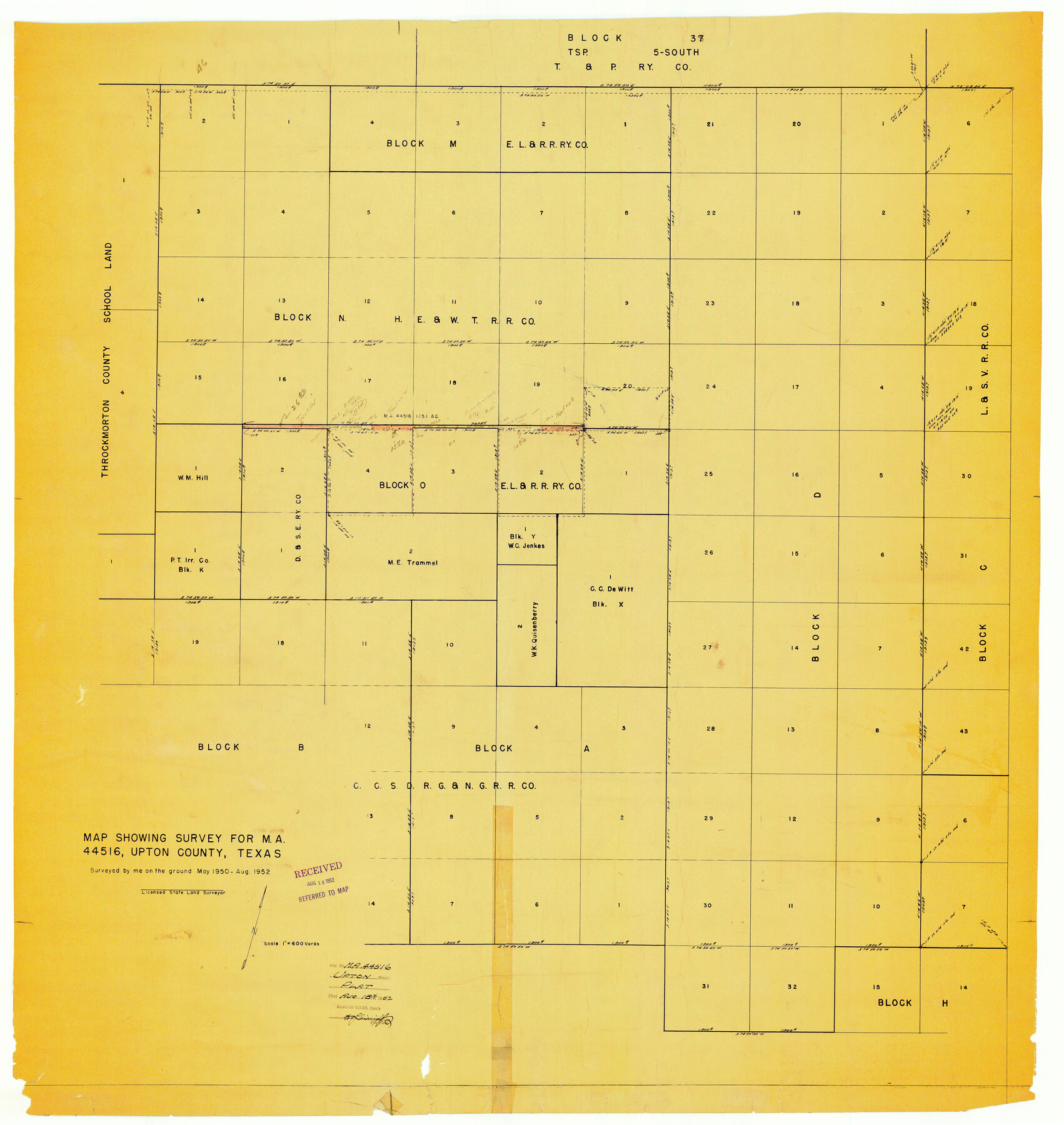
Upton County Rolled Sketch 37
Map showing survey for MA-44516, Upton County, Texas
-
Map/Doc
10053
-
Collection
General Map Collection
-
Object Dates
1952 (Survey Date)
1952/8/18 (File Date)
-
People and Organizations
Byron L. Simpson (Surveyor/Engineer)
-
Counties
Upton
-
Subjects
Surveying Rolled Sketch
-
Height x Width
41.8 x 39.6 inches
106.2 x 100.6 cm
-
Medium
blueprint/diazo
-
Scale
1" = 600 varas
Part of: General Map Collection
McLennan County Working Sketch 9

Print $20.00
- Digital $50.00
McLennan County Working Sketch 9
2008
Size 23.0 x 28.9 inches
Map/Doc 88768
Wichita County Rolled Sketch 12

Print $20.00
- Digital $50.00
Wichita County Rolled Sketch 12
Size 20.2 x 22.3 inches
Map/Doc 8249
Kinney County Working Sketch 3

Print $20.00
- Digital $50.00
Kinney County Working Sketch 3
Size 20.3 x 17.6 inches
Map/Doc 70185
Aransas County NRC Article 33.136 Sketch 11

Print $54.00
- Digital $50.00
Aransas County NRC Article 33.136 Sketch 11
2012
Size 36.0 x 48.0 inches
Map/Doc 94502
America's Fun-Tier: Texas 1965 Official Highway Travel Map

Digital $50.00
America's Fun-Tier: Texas 1965 Official Highway Travel Map
Size 28.2 x 36.4 inches
Map/Doc 94326
Childress County Working Sketch 4

Print $20.00
- Digital $50.00
Childress County Working Sketch 4
1939
Size 43.4 x 14.5 inches
Map/Doc 68020
Presidio County Working Sketch 76

Print $20.00
- Digital $50.00
Presidio County Working Sketch 76
1963
Size 29.8 x 30.8 inches
Map/Doc 71753
Starr County Rolled Sketch 31

Print $20.00
- Digital $50.00
Starr County Rolled Sketch 31
1941
Size 22.5 x 32.6 inches
Map/Doc 7828
Flight Mission No. CRK-8P, Frame 106, Refugio County

Print $20.00
- Digital $50.00
Flight Mission No. CRK-8P, Frame 106, Refugio County
1956
Size 18.3 x 22.1 inches
Map/Doc 86967
Hunt County Sketch File 10

Print $4.00
- Digital $50.00
Hunt County Sketch File 10
1859
Size 12.4 x 8.0 inches
Map/Doc 27100
Map of Comal County

Print $20.00
- Digital $50.00
Map of Comal County
1871
Size 16.0 x 19.7 inches
Map/Doc 3430
Jackson County Sketch File 29

Print $10.00
- Digital $50.00
Jackson County Sketch File 29
Size 13.4 x 8.7 inches
Map/Doc 27725
You may also like
Crane County Sketch File 16

Print $20.00
- Digital $50.00
Crane County Sketch File 16
Size 15.8 x 19.1 inches
Map/Doc 11209
Reeves County Sketch File 10

Print $20.00
- Digital $50.00
Reeves County Sketch File 10
Size 17.0 x 32.0 inches
Map/Doc 12244
[Northeast Portion of Hartley County]
![91118, [Northeast Portion of Hartley County], Twichell Survey Records](https://historictexasmaps.com/wmedia_w700/maps/91118-1.tif.jpg)
Print $2.00
- Digital $50.00
[Northeast Portion of Hartley County]
Size 13.9 x 8.5 inches
Map/Doc 91118
Haskell County Rolled Sketch 5

Print $20.00
- Digital $50.00
Haskell County Rolled Sketch 5
1858
Size 30.0 x 39.0 inches
Map/Doc 6165
Flight Mission No. CRC-4R, Frame 74, Chambers County

Print $20.00
- Digital $50.00
Flight Mission No. CRC-4R, Frame 74, Chambers County
1956
Size 18.7 x 22.5 inches
Map/Doc 84878
Revised Sectional Map No. 4 showing land surveys in the western portion of the county of El Paso, Texas

Print $20.00
- Digital $50.00
Revised Sectional Map No. 4 showing land surveys in the western portion of the county of El Paso, Texas
Size 19.0 x 24.2 inches
Map/Doc 4477
Falls County Sketch File 28

Print $2.00
- Digital $50.00
Falls County Sketch File 28
Size 7.7 x 10.3 inches
Map/Doc 22438
Montgomery County Sketch File 23

Print $6.00
- Digital $50.00
Montgomery County Sketch File 23
1841
Size 10.2 x 10.8 inches
Map/Doc 31865
Gray County, Texas

Print $20.00
- Digital $50.00
Gray County, Texas
Size 13.4 x 14.9 inches
Map/Doc 90722
Anderson County Working Sketch 36

Print $20.00
- Digital $50.00
Anderson County Working Sketch 36
1984
Size 36.3 x 45.6 inches
Map/Doc 67036
Navarro County Working Sketch 12

Print $40.00
- Digital $50.00
Navarro County Working Sketch 12
1979
Size 37.2 x 48.8 inches
Map/Doc 71242
Fannin County Working Sketch 10

Print $20.00
- Digital $50.00
Fannin County Working Sketch 10
1989
Size 26.5 x 38.0 inches
Map/Doc 69164