Aransas County NRC Article 33.136 Sketch 11
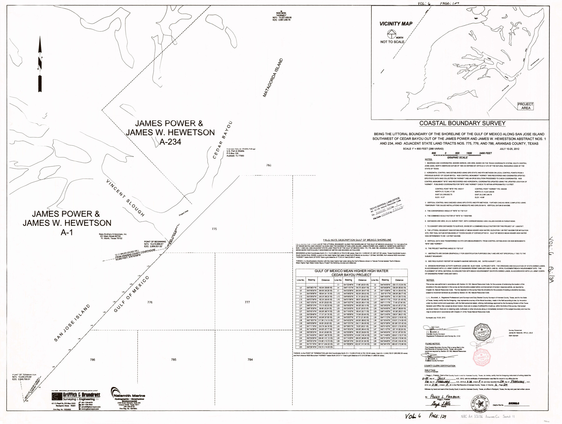
Coastal Boundary Survey being the littoral boundary of the shoreline of the Gulf of Mexico along San Jose Island southwest of Cedar Bayou out of the James Power and James W. Hewetson abstract nos. 1 and 234, and adjacent state land tracts 775, 776 and 786
-
Map/Doc
94502
-
Collection
General Map Collection
-
Object Dates
2012/7/25 (Creation Date)
2018/4/24 (File Date)
-
People and Organizations
J.L. Brundrett, Jr. (Surveyor/Engineer)
-
Counties
Aransas
-
Subjects
Surveying CBS
-
Height x Width
36.0 x 48.0 inches
91.4 x 121.9 cm
-
Medium
multi-page, multi-format
-
Comments
Project: Cedar Bayou - Gulf Beach nourishment/Dredge material placement Project No.: SL20110048 (GLO) SWG-2007-00813 (COE)
Related maps
Aransas County NRC Article 33.136 Sketch 12

Print $44.00
- Digital $50.00
Aransas County NRC Article 33.136 Sketch 12
2012
Size 36.0 x 48.0 inches
Map/Doc 94510
Part of: General Map Collection
Borden County Boundary File 3

Print $62.00
- Digital $50.00
Borden County Boundary File 3
1908
Size 28.7 x 82.9 inches
Map/Doc 1695
[F. W. & D. C. Ry. Co. Alignment and Right of Way Map, Clay County]
![64742, [F. W. & D. C. Ry. Co. Alignment and Right of Way Map, Clay County], General Map Collection](https://historictexasmaps.com/wmedia_w700/maps/64742-GC.tif.jpg)
Print $20.00
- Digital $50.00
[F. W. & D. C. Ry. Co. Alignment and Right of Way Map, Clay County]
1927
Size 18.8 x 11.8 inches
Map/Doc 64742
Orange County Working Sketch 17

Print $20.00
- Digital $50.00
Orange County Working Sketch 17
1930
Size 35.6 x 26.1 inches
Map/Doc 71349
South Part of Brewster Co.

Print $40.00
- Digital $50.00
South Part of Brewster Co.
1955
Size 48.8 x 40.0 inches
Map/Doc 66736
[Sketch for Mineral Application 17237 / Mineral File 11855 - Neches River, Joe A. Sanders]
![65687, [Sketch for Mineral Application 17237 / Mineral File 11855 - Neches River, Joe A. Sanders], General Map Collection](https://historictexasmaps.com/wmedia_w700/maps/65687.tif.jpg)
Print $40.00
- Digital $50.00
[Sketch for Mineral Application 17237 / Mineral File 11855 - Neches River, Joe A. Sanders]
1927
Size 78.5 x 31.2 inches
Map/Doc 65687
Nueces County Rolled Sketch 69

Print $20.00
- Digital $50.00
Nueces County Rolled Sketch 69
Size 23.8 x 33.0 inches
Map/Doc 6920

Bell County Sketch File 23

Print $4.00
- Digital $50.00
Bell County Sketch File 23
1873
Size 8.2 x 12.8 inches
Map/Doc 14414

Matagorda County Rolled Sketch 40

Print $20.00
- Digital $50.00
Matagorda County Rolled Sketch 40
Size 24.6 x 27.4 inches
Map/Doc 6704
Hudspeth County Sketch File 11b

Print $16.00
- Digital $50.00
Hudspeth County Sketch File 11b
Size 14.2 x 8.9 inches
Map/Doc 26914
Terrell County Rolled Sketch 29

Print $20.00
- Digital $50.00
Terrell County Rolled Sketch 29
1929
Size 27.5 x 41.9 inches
Map/Doc 7936
You may also like
Hill County Sketch File 20

Print $22.00
- Digital $50.00
Hill County Sketch File 20
1854
Size 8.3 x 7.7 inches
Map/Doc 26490
Culberson County Sketch [showing PSL Blocks 109-111, 113-115 and University Block 46]
![90500, Culberson County Sketch [showing PSL Blocks 109-111, 113-115 and University Block 46], Twichell Survey Records](https://historictexasmaps.com/wmedia_w700/maps/90500-1.tif.jpg)
Print $20.00
- Digital $50.00
Culberson County Sketch [showing PSL Blocks 109-111, 113-115 and University Block 46]
Size 25.8 x 12.7 inches
Map/Doc 90500
Stonewall County Rolled Sketch 22

Print $20.00
- Digital $50.00
Stonewall County Rolled Sketch 22
1951
Size 33.2 x 30.9 inches
Map/Doc 9961
[Sketch for Mineral Application 20124, North Fork of Red River]
![2826, [Sketch for Mineral Application 20124, North Fork of Red River], General Map Collection](https://historictexasmaps.com/wmedia_w700/maps/2826.tif.jpg)
Print $20.00
- Digital $50.00
[Sketch for Mineral Application 20124, North Fork of Red River]
1943
Size 18.5 x 26.0 inches
Map/Doc 2826
The Western Coast of Louisiana and The Coast of New Leon

Print $20.00
- Digital $50.00
The Western Coast of Louisiana and The Coast of New Leon
1775
Size 21.1 x 28.7 inches
Map/Doc 93705
Outer Continental Shelf Leasing Maps (Louisiana Offshore Operations)

Print $20.00
- Digital $50.00
Outer Continental Shelf Leasing Maps (Louisiana Offshore Operations)
1971
Size 20.2 x 15.0 inches
Map/Doc 76092
Flight Mission No. CRE-1R, Frame 129, Jackson County

Print $20.00
- Digital $50.00
Flight Mission No. CRE-1R, Frame 129, Jackson County
1956
Size 18.5 x 22.3 inches
Map/Doc 85337
Kent County Working Sketch 25

Print $20.00
- Digital $50.00
Kent County Working Sketch 25
1989
Size 18.8 x 18.5 inches
Map/Doc 69641
Sabine County Sketch File 6a

Print $4.00
Sabine County Sketch File 6a
1878
Size 8.1 x 12.5 inches
Map/Doc 35615
Rockwall County

Print $20.00
- Digital $50.00
Rockwall County
1941
Size 29.7 x 24.1 inches
Map/Doc 95628
Atascosa County Working Sketch 31

Print $20.00
- Digital $50.00
Atascosa County Working Sketch 31
1981
Size 21.4 x 16.6 inches
Map/Doc 67227
Limestone County Sketch File 11

Print $4.00
- Digital $50.00
Limestone County Sketch File 11
1881
Size 7.9 x 9.5 inches
Map/Doc 30177