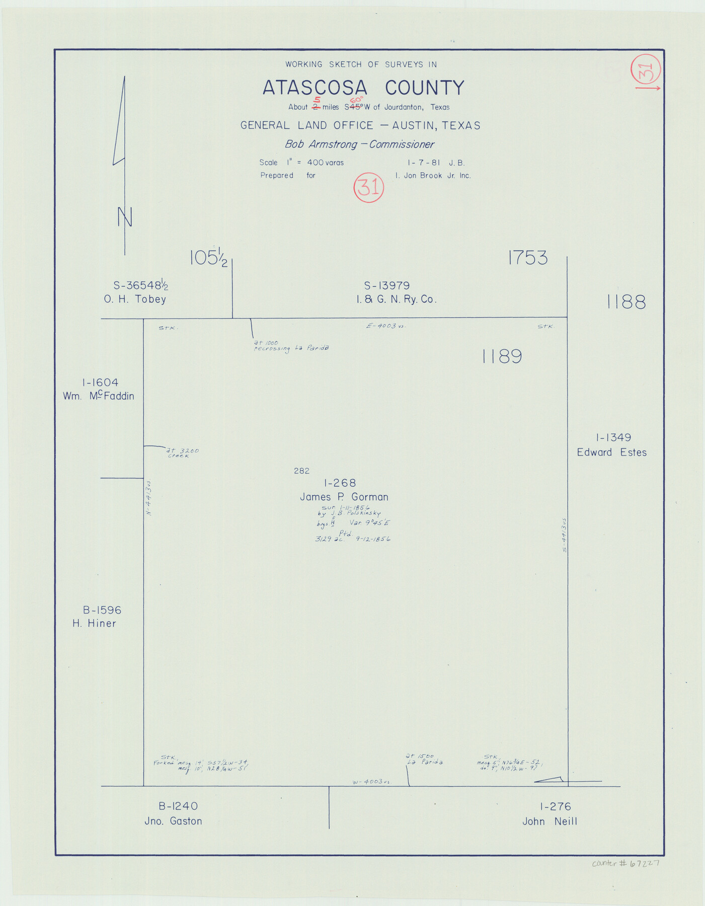
Atascosa County Working Sketch 31
-
Map/Doc
67227
-
Collection
General Map Collection
-
Object Dates
1/7/1981 (Creation Date)
-
People and Organizations
Jim Barber (Draftsman)
Bob Armstrong (GLO Commissioner)
-
Counties
Atascosa
-
Subjects
Surveying Working Sketch
-
Height x Width
21.4 x 16.6 inches
54.4 x 42.2 cm
-
Scale
1" = 400 varas
-
Comments
Survey located about five miles South 60 degrees West of Jourdanton, Texas.
Part of: General Map Collection
Andrews County Boundary File 5

Print $40.00
- Digital $50.00
Andrews County Boundary File 5
Size 29.8 x 19.6 inches
Map/Doc 49723

Brewster County Rolled Sketch 69

Print $20.00
- Digital $50.00
Brewster County Rolled Sketch 69
1940
Size 17.0 x 15.7 inches
Map/Doc 5235
Hardin County Sketch File 15

Print $6.00
- Digital $50.00
Hardin County Sketch File 15
Size 9.0 x 4.9 inches
Map/Doc 25122
Brewster County Rolled Sketch 29

Print $20.00
- Digital $50.00
Brewster County Rolled Sketch 29
1910
Size 17.5 x 18.5 inches
Map/Doc 5216
Grayson County Sketch File 25

Print $6.00
- Digital $50.00
Grayson County Sketch File 25
Size 8.4 x 7.1 inches
Map/Doc 24507
Andrews County Sketch File 6

Print $9.00
- Digital $50.00
Andrews County Sketch File 6
1942
Size 9.6 x 10.6 inches
Map/Doc 12825
Die Eisenbahm von dem Missisippi nach dem stillen Ocean (Californien)

Print $20.00
- Digital $50.00
Die Eisenbahm von dem Missisippi nach dem stillen Ocean (Californien)
1856
Size 14.0 x 14.8 inches
Map/Doc 94075
Township No. 4 South Range No. 17 West of the Indian Meridian

Print $20.00
- Digital $50.00
Township No. 4 South Range No. 17 West of the Indian Meridian
1875
Size 19.2 x 24.4 inches
Map/Doc 75164
Gonzales County

Print $20.00
- Digital $50.00
Gonzales County
1871
Size 17.2 x 25.8 inches
Map/Doc 3593
Calhoun County Rolled Sketch 13

Print $20.00
- Digital $50.00
Calhoun County Rolled Sketch 13
1948
Size 43.0 x 41.0 inches
Map/Doc 8547

You may also like
Wheeler County Rolled Sketch 3

Print $20.00
- Digital $50.00
Wheeler County Rolled Sketch 3
Size 31.9 x 21.9 inches
Map/Doc 8239
Anderson County Boundary File 8

Print $8.00
- Digital $50.00
Anderson County Boundary File 8
Size 14.5 x 8.8 inches
Map/Doc 49755
[Sketch for Mineral Application 26501 - Sabine River, T. A. Oldhausen]
![2833, [Sketch for Mineral Application 26501 - Sabine River, T. A. Oldhausen], General Map Collection](https://historictexasmaps.com/wmedia_w700/maps/2833.tif.jpg)
Print $20.00
- Digital $50.00
[Sketch for Mineral Application 26501 - Sabine River, T. A. Oldhausen]
1931
Size 24.4 x 36.3 inches
Map/Doc 2833
Clay County Sketch File 45

Print $20.00
- Digital $50.00
Clay County Sketch File 45
Size 23.5 x 35.4 inches
Map/Doc 11097
Upton County Working Sketch 52

Print $20.00
- Digital $50.00
Upton County Working Sketch 52
1983
Size 20.9 x 20.2 inches
Map/Doc 69549
Morris County Rolled Sketch 2A

Print $20.00
- Digital $50.00
Morris County Rolled Sketch 2A
Size 22.7 x 17.6 inches
Map/Doc 10268
United States - Gulf Coast - From Latitude 26° 33' to the Rio Grande Texas

Print $20.00
- Digital $50.00
United States - Gulf Coast - From Latitude 26° 33' to the Rio Grande Texas
1919
Size 27.5 x 18.2 inches
Map/Doc 72853
General Highway Map. Detail of Cities and Towns in Gray County, Texas. [Pampa and vicinity]
![79484, General Highway Map. Detail of Cities and Towns in Gray County, Texas. [Pampa and vicinity], Texas State Library and Archives](https://historictexasmaps.com/wmedia_w700/maps/79484.tif.jpg)
Print $20.00
General Highway Map. Detail of Cities and Towns in Gray County, Texas. [Pampa and vicinity]
1961
Size 24.7 x 18.1 inches
Map/Doc 79484
Map of Chicago, Rock Island & Texas Railroad

Print $40.00
- Digital $50.00
Map of Chicago, Rock Island & Texas Railroad
1892
Size 23.9 x 122.0 inches
Map/Doc 64442
Knox County Working Sketch 8

Print $20.00
- Digital $50.00
Knox County Working Sketch 8
1942
Size 38.7 x 14.3 inches
Map/Doc 70250
Terrell County Working Sketch 79

Print $40.00
- Digital $50.00
Terrell County Working Sketch 79
1983
Size 43.0 x 55.8 inches
Map/Doc 69600
Gillespie County Working Sketch 6

Print $20.00
- Digital $50.00
Gillespie County Working Sketch 6
1981
Size 22.5 x 21.6 inches
Map/Doc 63169