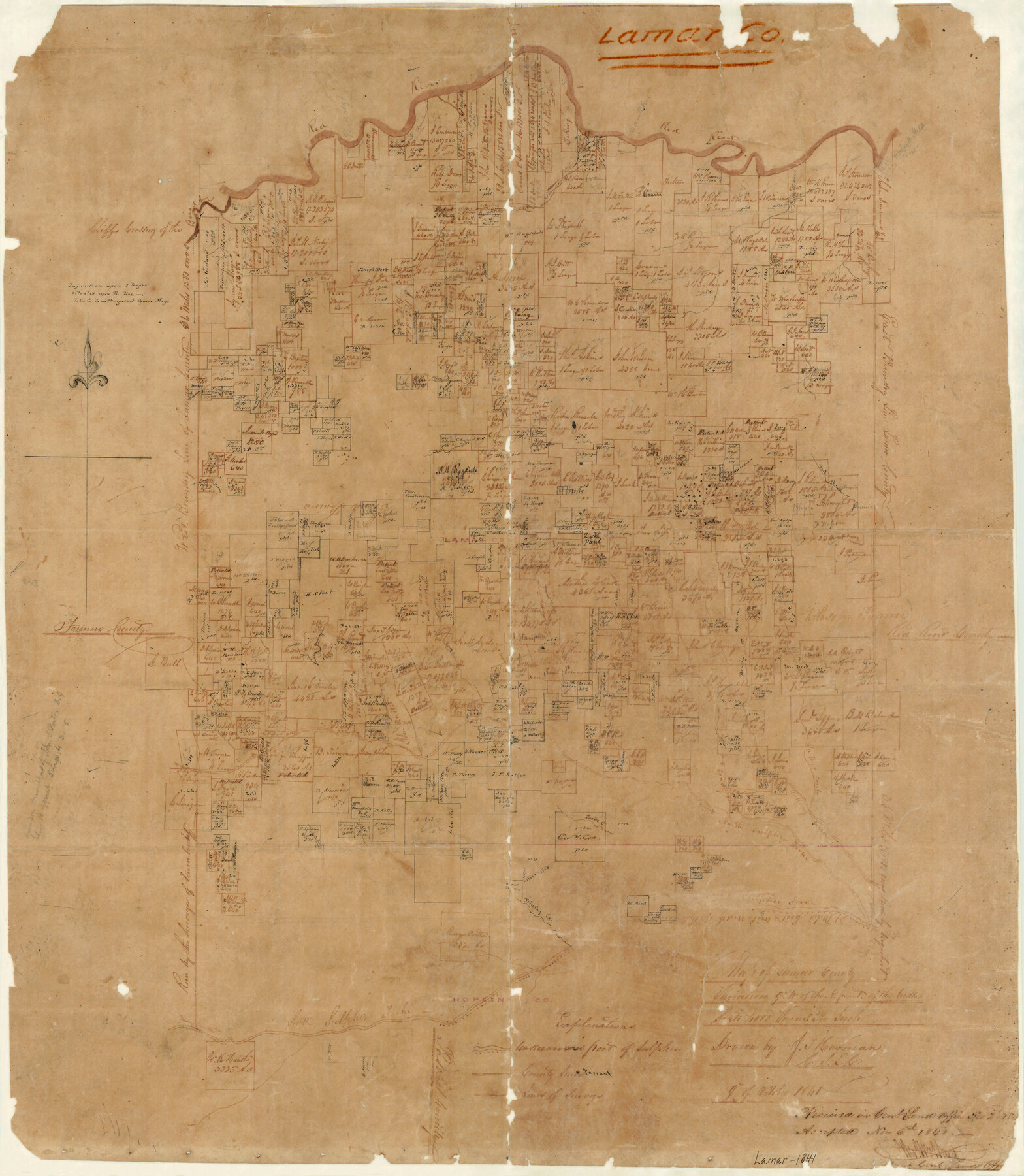
Lamar County
-
Map/Doc
3788
-
Collection
General Map Collection
-
Object Dates
10/9/1841 (Creation Date)
11/6/1841 (File Date)
-
People and Organizations
J. Harman (Surveyor/Engineer)
-
Counties
Lamar
-
Subjects
County
-
Height x Width
25.6 x 22.4 inches
65.0 x 56.9 cm
-
Comments
Received in General Land Office November 2, 1841.
-
Features
Cliffs Crossing
South Sulphur Fork
Doctor Creek
Tarrant
Brushy Creek
Lake Creek
North Sulphur Fork
Brigham Creek
Sandy Creek
Mulberry Creek
Bois de Arc Creek
Hickory Creek
Honey Creek
Paris
Wards Creek
Pine Creek
Pine Hill
Franklin
Hidalgo
Red River
Part of: General Map Collection
Moore County Working Sketch 15

Print $20.00
- Digital $50.00
Moore County Working Sketch 15
1981
Size 20.8 x 35.3 inches
Map/Doc 71197
Flight Mission No. DAG-19K, Frame 66, Matagorda County

Print $20.00
- Digital $50.00
Flight Mission No. DAG-19K, Frame 66, Matagorda County
1952
Size 16.3 x 16.3 inches
Map/Doc 86393
McLennan County Sketch File 22

Print $3.00
- Digital $50.00
McLennan County Sketch File 22
1869
Size 11.1 x 9.3 inches
Map/Doc 31296
Winkler County Sketch File 14

Print $20.00
- Digital $50.00
Winkler County Sketch File 14
Size 29.4 x 24.3 inches
Map/Doc 12698
Parker County Sketch File 44

Print $6.00
- Digital $50.00
Parker County Sketch File 44
1874
Size 11.0 x 13.5 inches
Map/Doc 33608

Flight Mission No. CUG-1P, Frame 73, Kleberg County

Print $20.00
- Digital $50.00
Flight Mission No. CUG-1P, Frame 73, Kleberg County
1956
Size 18.4 x 22.5 inches
Map/Doc 86138
Kimble County Rolled Sketch 17 1/2

Print $59.00
- Digital $50.00
Kimble County Rolled Sketch 17 1/2
1889
Size 27.0 x 38.3 inches
Map/Doc 6510
Mills County Boundary File 5a

Print $14.00
- Digital $50.00
Mills County Boundary File 5a
Size 14.3 x 8.6 inches
Map/Doc 57300
[Victor Blanco's survey along the San Antonio River]
![187, [Victor Blanco's survey along the San Antonio River], General Map Collection](https://historictexasmaps.com/wmedia_w700/maps/187.tif.jpg)
Print $2.00
- Digital $50.00
[Victor Blanco's survey along the San Antonio River]
Size 11.2 x 8.2 inches
Map/Doc 187
Bastrop County Boundary File 2

Print $12.00
- Digital $50.00
Bastrop County Boundary File 2
Size 9.1 x 6.9 inches
Map/Doc 50315
Bexar County Rolled Sketch 4A

Print $20.00
- Digital $50.00
Bexar County Rolled Sketch 4A
1982
Size 24.4 x 36.7 inches
Map/Doc 5138
You may also like
El Paso County Rolled Sketch 52

Print $20.00
- Digital $50.00
El Paso County Rolled Sketch 52
1930
Size 18.5 x 24.4 inches
Map/Doc 5837
Brewster County Working Sketch 111

Print $40.00
- Digital $50.00
Brewster County Working Sketch 111
1982
Size 21.5 x 55.9 inches
Map/Doc 67711
Jeff Davis County Working Sketch 13

Print $20.00
- Digital $50.00
Jeff Davis County Working Sketch 13
1949
Size 24.5 x 32.7 inches
Map/Doc 66508
Grimes County Working Sketch 6

Print $20.00
- Digital $50.00
Grimes County Working Sketch 6
1951
Size 33.2 x 33.4 inches
Map/Doc 63297
[Leagues 212- 217, 241- 244, and Vicinity]
![91430, [Leagues 212- 217, 241- 244, and Vicinity], Twichell Survey Records](https://historictexasmaps.com/wmedia_w700/maps/91430-1.tif.jpg)
Print $20.00
- Digital $50.00
[Leagues 212- 217, 241- 244, and Vicinity]
1902
Size 20.6 x 6.4 inches
Map/Doc 91430
Upshur County Working Sketch 16

Print $20.00
- Digital $50.00
Upshur County Working Sketch 16
1997
Size 43.7 x 36.0 inches
Map/Doc 78229
Clay County Sketch File 14

Print $40.00
- Digital $50.00
Clay County Sketch File 14
1873
Size 16.5 x 13.8 inches
Map/Doc 18417
Newton County Rolled Sketch JFB

Print $20.00
- Digital $50.00
Newton County Rolled Sketch JFB
1936
Size 16.0 x 38.3 inches
Map/Doc 6858
Mrs. R. L. Westerman Subdivision of 2 1/2 Acres out of North Half of Survey Number 1, Block Number 36, Township 5 North. Dawson County, Texas

Print $20.00
- Digital $50.00
Mrs. R. L. Westerman Subdivision of 2 1/2 Acres out of North Half of Survey Number 1, Block Number 36, Township 5 North. Dawson County, Texas
1924
Size 18.6 x 24.5 inches
Map/Doc 92591
Cameron County NRC Article 33.136 Location Key Sheet

Print $20.00
- Digital $50.00
Cameron County NRC Article 33.136 Location Key Sheet
1983
Size 27.0 x 22.0 inches
Map/Doc 77012
Val Verde County Working Sketch 7

Print $20.00
- Digital $50.00
Val Verde County Working Sketch 7
1915
Size 21.9 x 19.5 inches
Map/Doc 72142
