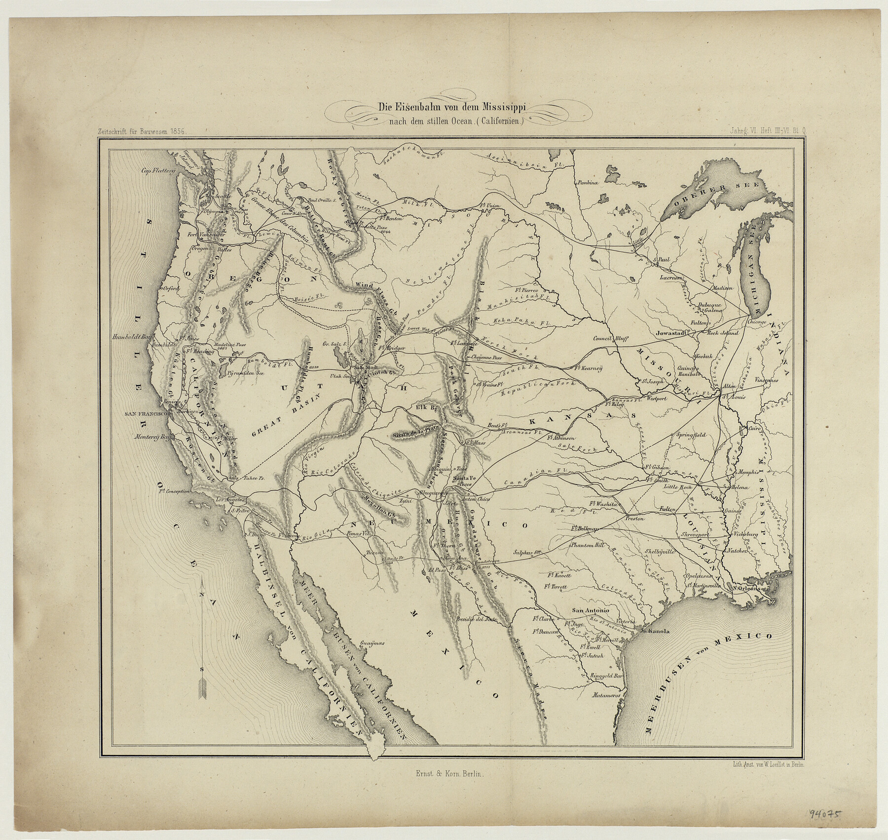
Die Eisenbahm von dem Missisippi nach dem stillen Ocean (Californien)
-
Map/Doc
94075
-
Collection
General Map Collection
-
Object Dates
1856 (Creation Date)
-
People and Organizations
Ernst & Korn (Publisher)
W. Loeillot (Printer)
-
Subjects
New Southwest Railroads State of Texas
-
Height x Width
14.0 x 14.8 inches
35.6 x 37.6 cm
-
Medium
paper, etching/engraving/lithograph
Part of: General Map Collection
Smith County Sketch File 19

Print $42.00
- Digital $50.00
Smith County Sketch File 19
1850
Size 8.1 x 13.0 inches
Map/Doc 36794
Live Oak County Working Sketch 7

Print $20.00
- Digital $50.00
Live Oak County Working Sketch 7
1937
Size 24.9 x 37.6 inches
Map/Doc 70592
Henderson County Sketch File 9

Print $8.00
- Digital $50.00
Henderson County Sketch File 9
Size 8.3 x 7.8 inches
Map/Doc 26343
Map of Wood County

Print $20.00
- Digital $50.00
Map of Wood County
1857
Size 22.5 x 29.1 inches
Map/Doc 4165
Nueces County NRC Article 33.136 Location Key Sheet

Print $20.00
- Digital $50.00
Nueces County NRC Article 33.136 Location Key Sheet
1975
Size 27.0 x 23.0 inches
Map/Doc 77031
Brewster County Sketch File N-27

Print $40.00
- Digital $50.00
Brewster County Sketch File N-27
Size 16.0 x 17.9 inches
Map/Doc 10972
La Salle County Sketch File 41

Print $20.00
- Digital $50.00
La Salle County Sketch File 41
1918
Size 25.8 x 15.9 inches
Map/Doc 11986
Leon County Working Sketch 35

Print $20.00
- Digital $50.00
Leon County Working Sketch 35
1978
Size 43.8 x 38.3 inches
Map/Doc 70434

Flight Mission No. DAG-28K, Frame 29, Matagorda County

Print $20.00
- Digital $50.00
Flight Mission No. DAG-28K, Frame 29, Matagorda County
1953
Size 16.2 x 16.1 inches
Map/Doc 86597
Rio Grande Rectification Project, El Paso and Juarez Valley

Print $20.00
- Digital $50.00
Rio Grande Rectification Project, El Paso and Juarez Valley
1935
Size 10.7 x 29.6 inches
Map/Doc 60862
Wheeler County Working Sketch 14

Print $20.00
- Digital $50.00
Wheeler County Working Sketch 14
1979
Size 20.1 x 37.2 inches
Map/Doc 72503
You may also like
Maps of Gulf Intracoastal Waterway, Texas - Sabine River to the Rio Grande and connecting waterways including ship channels

Print $20.00
- Digital $50.00
Maps of Gulf Intracoastal Waterway, Texas - Sabine River to the Rio Grande and connecting waterways including ship channels
1966
Size 14.6 x 22.3 inches
Map/Doc 61959
Dickens County Working Sketch 11

Print $40.00
- Digital $50.00
Dickens County Working Sketch 11
1969
Size 52.6 x 37.8 inches
Map/Doc 68659
Trinity County Sketch File 33

Print $6.00
- Digital $50.00
Trinity County Sketch File 33
1922
Size 11.2 x 8.9 inches
Map/Doc 38572
Galveston County NRC Article 33.136 Sketch 55B

Print $24.00
- Digital $50.00
Galveston County NRC Article 33.136 Sketch 55B
2007
Size 24.0 x 36.0 inches
Map/Doc 94666
Map of Bowie County, Texas

Print $20.00
- Digital $50.00
Map of Bowie County, Texas
1879
Size 21.2 x 24.4 inches
Map/Doc 607
Garza County Sketch File G-1

Print $20.00
- Digital $50.00
Garza County Sketch File G-1
1904
Size 20.4 x 20.6 inches
Map/Doc 11554
Sketch Showing Original Corners and Connections affecting Blocks T1, T2, and T3 in Lamb and Castro Counties, Texas

Print $20.00
- Digital $50.00
Sketch Showing Original Corners and Connections affecting Blocks T1, T2, and T3 in Lamb and Castro Counties, Texas
Size 17.3 x 29.1 inches
Map/Doc 92982
[River Meander along Jas. Tobin Survey and others]
![89814, [River Meander along Jas. Tobin Survey and others], Twichell Survey Records](https://historictexasmaps.com/wmedia_w700/maps/89814-1.tif.jpg)
Print $40.00
- Digital $50.00
[River Meander along Jas. Tobin Survey and others]
Size 73.6 x 43.9 inches
Map/Doc 89814

[Sketch for Mineral Application 24072, San Jacinto River]
![65609, [Sketch for Mineral Application 24072, San Jacinto River], General Map Collection](https://historictexasmaps.com/wmedia_w700/maps/65609.tif.jpg)
Print $20.00
- Digital $50.00
[Sketch for Mineral Application 24072, San Jacinto River]
1929
Size 8.4 x 13.9 inches
Map/Doc 65609
Comal County Sketch File 5

Print $4.00
- Digital $50.00
Comal County Sketch File 5
1848
Size 12.9 x 8.4 inches
Map/Doc 19006
Flight Mission No. CRC-5R, Frame 25, Chambers County

Print $20.00
- Digital $50.00
Flight Mission No. CRC-5R, Frame 25, Chambers County
1956
Size 18.9 x 22.4 inches
Map/Doc 84947