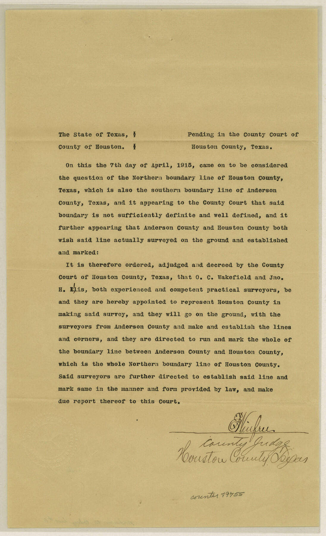
Anderson County Boundary File 8
Certified copy of order appointing surveyors to run County Line
-
Map/Doc
49755
-
Collection
General Map Collection
-
Counties
Anderson
-
Subjects
County Boundaries
-
Height x Width
14.5 x 8.8 inches
36.8 x 22.4 cm
Part of: General Map Collection
Duval County Sketch File 58

Print $20.00
- Digital $50.00
Duval County Sketch File 58
1940
Size 18.3 x 19.0 inches
Map/Doc 11406
Loving County Sketch File 6

Print $10.00
- Digital $50.00
Loving County Sketch File 6
1963
Size 7.2 x 5.9 inches
Map/Doc 41451
Terrell County Working Sketch 85

Print $20.00
- Digital $50.00
Terrell County Working Sketch 85
1994
Size 31.3 x 42.8 inches
Map/Doc 69609
Flight Mission No. CGI-4N, Frame 175, Cameron County

Print $20.00
- Digital $50.00
Flight Mission No. CGI-4N, Frame 175, Cameron County
1955
Size 18.6 x 22.4 inches
Map/Doc 84678
Hudspeth County Sketch File 38

Print $20.00
- Digital $50.00
Hudspeth County Sketch File 38
Size 27.5 x 24.1 inches
Map/Doc 11806
Floyd County Rolled Sketch 8

Print $20.00
- Digital $50.00
Floyd County Rolled Sketch 8
1947
Size 29.6 x 19.9 inches
Map/Doc 5882
Montgomery County Working Sketch 16

Print $20.00
- Digital $50.00
Montgomery County Working Sketch 16
1934
Size 28.9 x 33.7 inches
Map/Doc 71123
Flight Mission No. DIX-6P, Frame 186, Aransas County

Print $20.00
- Digital $50.00
Flight Mission No. DIX-6P, Frame 186, Aransas County
1956
Size 19.2 x 22.9 inches
Map/Doc 83848
Terrell County Rolled Sketch 9

Print $20.00
- Digital $50.00
Terrell County Rolled Sketch 9
Size 17.6 x 42.9 inches
Map/Doc 7925
El Paso County Rolled Sketch 30

Print $20.00
- Digital $50.00
El Paso County Rolled Sketch 30
1906
Size 40.9 x 22.8 inches
Map/Doc 5825
Madison County Working Sketch 6

Print $2.00
- Digital $50.00
Madison County Working Sketch 6
1982
Size 10.5 x 7.7 inches
Map/Doc 70768
Navigation Maps of Gulf Intracoastal Waterway, Port Arthur to Brownsville, Texas

Print $4.00
- Digital $50.00
Navigation Maps of Gulf Intracoastal Waterway, Port Arthur to Brownsville, Texas
1951
Size 16.6 x 21.2 inches
Map/Doc 65445
You may also like
Castro County Sketch File 5

Print $20.00
- Digital $50.00
Castro County Sketch File 5
Size 37.6 x 25.3 inches
Map/Doc 11058
Plat of Surveys in Hidalgo Co.

Print $20.00
- Digital $50.00
Plat of Surveys in Hidalgo Co.
Size 18.3 x 9.2 inches
Map/Doc 75548
Map Showing Block HG and Connecting Surveys

Print $2.00
- Digital $50.00
Map Showing Block HG and Connecting Surveys
1907
Size 9.2 x 13.7 inches
Map/Doc 90681
Trinity County Sketch File 36a

Print $40.00
- Digital $50.00
Trinity County Sketch File 36a
1921
Size 18.5 x 8.6 inches
Map/Doc 38589
Sutton County Sketch File 23

Print $30.00
- Digital $50.00
Sutton County Sketch File 23
1918
Size 14.2 x 8.5 inches
Map/Doc 37461
Whitehead Second Addition

Print $20.00
- Digital $50.00
Whitehead Second Addition
Size 11.0 x 18.6 inches
Map/Doc 92879
Flight Mission No. CGI-3N, Frame 180, Cameron County

Print $20.00
- Digital $50.00
Flight Mission No. CGI-3N, Frame 180, Cameron County
1954
Size 18.6 x 22.2 inches
Map/Doc 84644
[Beaumont, Sour Lake and Western Ry. Right of Way and Alignment - Frisco]
![64130, [Beaumont, Sour Lake and Western Ry. Right of Way and Alignment - Frisco], General Map Collection](https://historictexasmaps.com/wmedia_w700/maps/64130.tif.jpg)
Print $20.00
- Digital $50.00
[Beaumont, Sour Lake and Western Ry. Right of Way and Alignment - Frisco]
1910
Size 20.3 x 45.9 inches
Map/Doc 64130
Reagan County Rolled Sketch 31

Print $20.00
- Digital $50.00
Reagan County Rolled Sketch 31
1955
Size 26.5 x 28.8 inches
Map/Doc 7447
[County School Land for Shackelford, Reeves, Hardeman, Val Verde, Hood, Martin, Rusk, Atascosa, and Edwards Counties]
![91100, [County School Land for Shackelford, Reeves, Hardeman, Val Verde, Hood, Martin, Rusk, Atascosa, and Edwards Counties], Twichell Survey Records](https://historictexasmaps.com/wmedia_w700/maps/91100-1.tif.jpg)
Print $2.00
- Digital $50.00
[County School Land for Shackelford, Reeves, Hardeman, Val Verde, Hood, Martin, Rusk, Atascosa, and Edwards Counties]
Size 7.5 x 6.4 inches
Map/Doc 91100
Flight Mission No. CRE-1R, Frame 66, Jackson County

Print $20.00
- Digital $50.00
Flight Mission No. CRE-1R, Frame 66, Jackson County
1956
Size 16.2 x 16.1 inches
Map/Doc 85329
Hemphill County Rolled Sketch 17

Print $20.00
- Digital $50.00
Hemphill County Rolled Sketch 17
1965
Size 29.2 x 40.1 inches
Map/Doc 6198