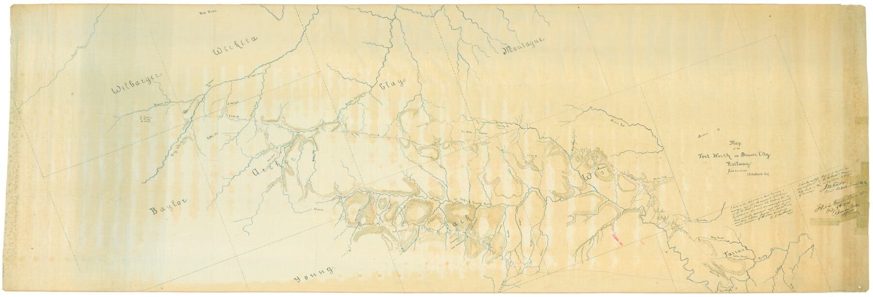
Map of the Fort Worth and Denver City Railway
Z-2-194
-
Map/Doc
64778
-
Collection
General Map Collection
-
Object Dates
1873/11/25 (Survey Date)
1874/2/6 (File Date)
1873 (Creation Date)
-
People and Organizations
C.R. Hubbard (Surveyor/Engineer)
J.M. Eddy (Agent)
Rhoads Fisher (GLO Clerk)
-
Counties
Wilbarger Wichita Baylor Archer Clay Montague Young Jack Wise Tarrant
-
Subjects
Railroads
-
Height x Width
31.6 x 90.3 inches
80.3 x 229.4 cm
-
Medium
linen, manuscript
-
Scale
1in = 2 miles
-
Features
Little Fossil Creek
Jasper Creek
Boone Creek
East Fork of Keehi
Decatur
Denton
Oliver Creek
Deep Creek
Blue Creek
Indian Creek
Henrietta Creek
Big Fossil Creek
Beans Creek
Marine Creek
Fort Worth
Trinity River
Village Creek
Rush Creek
Pease River
Cameron Creek
Plum Creek
Lost Valley Creek
Red River
FW&DC
Onion Creek
Mt. Lawrence
Mt. Eddy
Mt. Frost
Signal Hill
Big Wichita
The Twins
Copper Mound
Barry Mt.
Holiday Creek
Goble Mt.
Little Wichita
Beaver Creek
Buffalo Spring
Ten Mile Prairie
Sandy River
Cottonwood River
West Fork of the Trinity River
Brushy Creek
Lost Creek
Jacksboro
Fort Richardson
Carrolls Creek
Part of: General Map Collection
Map of the Cotton Belt Route, St. Louis Southwestern Railway Co., St. Louis Southwestern Railway Co. of Texas, Tyler Southeastern Railway Co. and connections

Print $20.00
- Digital $50.00
Map of the Cotton Belt Route, St. Louis Southwestern Railway Co., St. Louis Southwestern Railway Co. of Texas, Tyler Southeastern Railway Co. and connections
1898
Size 15.3 x 35.7 inches
Map/Doc 93954
Intracoastal Waterway in Texas - Corpus Christi to Point Isabel including Arroyo Colorado to Mo. Pac. R.R. Bridge Near Harlingen

Print $20.00
- Digital $50.00
Intracoastal Waterway in Texas - Corpus Christi to Point Isabel including Arroyo Colorado to Mo. Pac. R.R. Bridge Near Harlingen
1933
Size 28.0 x 41.0 inches
Map/Doc 61875
Comal County Sketch File 8

Print $6.00
- Digital $50.00
Comal County Sketch File 8
1849
Size 12.6 x 10.8 inches
Map/Doc 19013
Sketch of coast of Texas, Laguna Madre from Pt. of Rocks to Corpus Christi [and accompanying letter]
![72962, Sketch of coast of Texas, Laguna Madre from Pt. of Rocks to Corpus Christi [and accompanying letter], General Map Collection](https://historictexasmaps.com/wmedia_w700/maps/72962.tif.jpg)
Print $20.00
- Digital $50.00
Sketch of coast of Texas, Laguna Madre from Pt. of Rocks to Corpus Christi [and accompanying letter]
1881
Size 26.5 x 18.3 inches
Map/Doc 72962
Live Oak County Sketch File 13

Print $17.00
- Digital $50.00
Live Oak County Sketch File 13
1880
Size 10.2 x 13.7 inches
Map/Doc 30270
Reeves County Sketch File 26

Print $4.00
- Digital $50.00
Reeves County Sketch File 26
1964
Size 4.1 x 8.8 inches
Map/Doc 35226
Crockett County Rolled Sketch 62

Print $20.00
- Digital $50.00
Crockett County Rolled Sketch 62
1947
Size 27.0 x 38.1 inches
Map/Doc 5605
Chambers County NRC Article 33.136 Location Key Sheet

Print $20.00
- Digital $50.00
Chambers County NRC Article 33.136 Location Key Sheet
1982
Size 27.0 x 22.0 inches
Map/Doc 87908
Map of Castro's Colony - Bexar District

Print $20.00
- Digital $50.00
Map of Castro's Colony - Bexar District
1851
Size 36.4 x 33.1 inches
Map/Doc 1962
Medina County Working Sketch 24

Print $20.00
- Digital $50.00
Medina County Working Sketch 24
1984
Size 26.1 x 36.7 inches
Map/Doc 70939

Brewster County Sketch File S-27

Print $10.00
- Digital $50.00
Brewster County Sketch File S-27
1966
Size 11.4 x 8.7 inches
Map/Doc 15841
You may also like
Reeves County Sketch File 21

Print $20.00
- Digital $50.00
Reeves County Sketch File 21
Size 21.9 x 21.7 inches
Map/Doc 12246
Brewster County Sketch File 51

Print $20.00
- Digital $50.00
Brewster County Sketch File 51
1996
Size 13.8 x 8.3 inches
Map/Doc 16352
[Rusk, Sutton, Garza, and Atascosa County School Lands]
![91125, [Rusk, Sutton, Garza, and Atascosa County School Lands], Twichell Survey Records](https://historictexasmaps.com/wmedia_w700/maps/91125-1.tif.jpg)
Print $3.00
- Digital $50.00
[Rusk, Sutton, Garza, and Atascosa County School Lands]
1913
Size 12.5 x 9.4 inches
Map/Doc 91125
Crockett County Rolled Sketch 88B

Print $20.00
- Digital $50.00
Crockett County Rolled Sketch 88B
1973
Size 35.1 x 38.9 inches
Map/Doc 8727
Liberty County Sketch File 58

Print $2.00
- Digital $50.00
Liberty County Sketch File 58
Size 8.9 x 7.7 inches
Map/Doc 30060
Eastland County Rolled Sketch 14

Print $20.00
- Digital $50.00
Eastland County Rolled Sketch 14
Size 18.5 x 18.3 inches
Map/Doc 5775
Intracoastal Waterway - Port Arthur to Galveston Bay

Print $20.00
- Digital $50.00
Intracoastal Waterway - Port Arthur to Galveston Bay
1957
Size 27.0 x 38.6 inches
Map/Doc 69830
[Ft. W. & R. G. Ry. Right of Way Map, Chapin to Bluffdale, Hood County, Texas]
![64646, [Ft. W. & R. G. Ry. Right of Way Map, Chapin to Bluffdale, Hood County, Texas], General Map Collection](https://historictexasmaps.com/wmedia_w700/maps/64646.tif.jpg)
Print $40.00
- Digital $50.00
[Ft. W. & R. G. Ry. Right of Way Map, Chapin to Bluffdale, Hood County, Texas]
1918
Size 36.8 x 69.7 inches
Map/Doc 64646
Nueces County Rolled Sketch 126

Print $20.00
- Digital $50.00
Nueces County Rolled Sketch 126
1998
Size 24.5 x 36.8 inches
Map/Doc 7161
Map of the Northeast Part of the Pitchfork Ranch

Print $20.00
- Digital $50.00
Map of the Northeast Part of the Pitchfork Ranch
1916
Size 23.4 x 23.4 inches
Map/Doc 90980
Flight Mission No. DQN-3K, Frame 5, Calhoun County

Print $20.00
- Digital $50.00
Flight Mission No. DQN-3K, Frame 5, Calhoun County
1953
Size 18.4 x 22.1 inches
Map/Doc 84337
Glasscock County Working Sketch 11

Print $40.00
- Digital $50.00
Glasscock County Working Sketch 11
1957
Size 87.4 x 36.2 inches
Map/Doc 63184