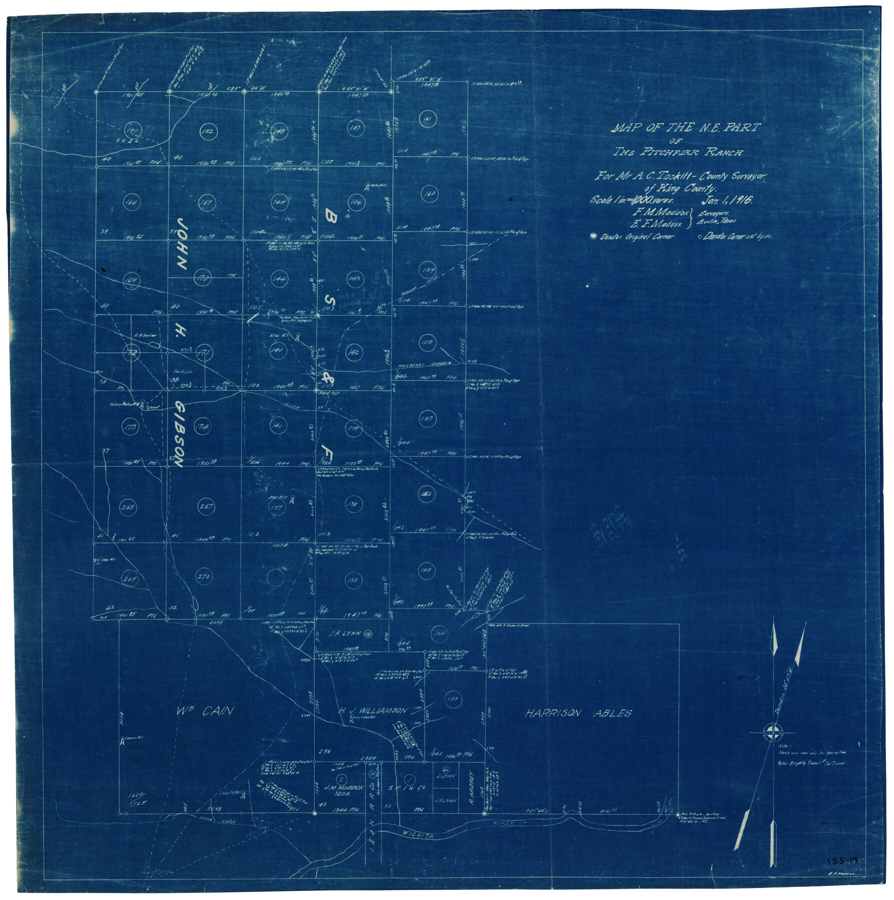
Map of the Northeast Part of the Pitchfork Ranch
135-19
-
Map/Doc
90980
-
Collection
Twichell Survey Records
-
Object Dates
1/1/1916 (Creation Date)
-
People and Organizations
E.F. Maddox (Draftsman)
F.M. Maddox (Surveyor/Engineer)
-
Counties
King
-
Height x Width
23.4 x 23.4 inches
59.4 x 59.4 cm
Part of: Twichell Survey Records
[Capitol Leagues 225-238]
![90676, [Capitol Leagues 225-238], Twichell Survey Records](https://historictexasmaps.com/wmedia_w700/maps/90676-1.tif.jpg)
Print $20.00
- Digital $50.00
[Capitol Leagues 225-238]
Size 23.1 x 13.6 inches
Map/Doc 90676
[C. C. Slaughter Block 1, T. T. RR. Co. Block 2]
![90621, [C. C. Slaughter Block 1, T. T. RR. Co. Block 2], Twichell Survey Records](https://historictexasmaps.com/wmedia_w700/maps/90621-1.tif.jpg)
Print $2.00
- Digital $50.00
[C. C. Slaughter Block 1, T. T. RR. Co. Block 2]
Size 8.6 x 11.5 inches
Map/Doc 90621
Block I, Dickens County Compiled by W.D. Twichell as directed by Cowan & Burney Upon G.M. Williams' Measurements

Print $20.00
- Digital $50.00
Block I, Dickens County Compiled by W.D. Twichell as directed by Cowan & Burney Upon G.M. Williams' Measurements
1916
Size 41.5 x 41.7 inches
Map/Doc 89770
[Littlefield Subdivision Blocks 657-687]
![91008, [Littlefield Subdivision Blocks 657-687], Twichell Survey Records](https://historictexasmaps.com/wmedia_w700/maps/91008-1.tif.jpg)
Print $20.00
- Digital $50.00
[Littlefield Subdivision Blocks 657-687]
Size 15.7 x 12.1 inches
Map/Doc 91008
[Area around John P. Rohus Survey]
![91913, [Area around John P. Rohus Survey], Twichell Survey Records](https://historictexasmaps.com/wmedia_w700/maps/91913-1.tif.jpg)
Print $20.00
- Digital $50.00
[Area around John P. Rohus Survey]
Size 19.7 x 19.7 inches
Map/Doc 91913
[Sketch of Blocks M-19, 21W, JAD, 9 and G. & M. Block 5]
![91736, [Sketch of Blocks M-19, 21W, JAD, 9 and G. & M. Block 5], Twichell Survey Records](https://historictexasmaps.com/wmedia_w700/maps/91736-1.tif.jpg)
Print $20.00
- Digital $50.00
[Sketch of Blocks M-19, 21W, JAD, 9 and G. & M. Block 5]
Size 34.0 x 25.9 inches
Map/Doc 91736
[Sections 69-84 Block 47 and part of Block 3]
![91795, [Sections 69-84 Block 47 and part of Block 3], Twichell Survey Records](https://historictexasmaps.com/wmedia_w700/maps/91795-1.tif.jpg)
Print $2.00
- Digital $50.00
[Sections 69-84 Block 47 and part of Block 3]
Size 14.3 x 8.9 inches
Map/Doc 91795
Scurry County Sketch Mineral Application No. 42315

Print $20.00
- Digital $50.00
Scurry County Sketch Mineral Application No. 42315
1950
Size 24.0 x 16.5 inches
Map/Doc 92965
W. D. Twichell's and R. S. Hunnicutt's Resurvey in Oldham County, Texas May to October, 1916

Print $40.00
- Digital $50.00
W. D. Twichell's and R. S. Hunnicutt's Resurvey in Oldham County, Texas May to October, 1916
1915
Size 48.0 x 39.0 inches
Map/Doc 89975
Counties of Martin, Dawson, Borden, and Howard, Texas Soash Lands, Big Springs Ranch

Print $20.00
- Digital $50.00
Counties of Martin, Dawson, Borden, and Howard, Texas Soash Lands, Big Springs Ranch
Size 35.3 x 39.0 inches
Map/Doc 91224
Rhyne Simpson Quirt Avenue Addition to the City of Lubbock

Print $20.00
- Digital $50.00
Rhyne Simpson Quirt Avenue Addition to the City of Lubbock
1954
Size 19.3 x 40.5 inches
Map/Doc 92877
Pecos County Sketch showing location of oil wells within 1/2 mile radius of the south 8 acres of the Bob Reid survey

Print $20.00
- Digital $50.00
Pecos County Sketch showing location of oil wells within 1/2 mile radius of the south 8 acres of the Bob Reid survey
Size 18.4 x 16.5 inches
Map/Doc 91639
You may also like
San Patricio County Working Sketch 23

Print $20.00
- Digital $50.00
San Patricio County Working Sketch 23
1984
Size 43.5 x 43.8 inches
Map/Doc 63785
Galveston County Sketch File 47

Print $14.00
- Digital $50.00
Galveston County Sketch File 47
1976
Size 11.3 x 8.9 inches
Map/Doc 23454
Matagorda County NRC Article 33.136 Sketch 22

Print $24.00
Matagorda County NRC Article 33.136 Sketch 22
2025
Map/Doc 97486
Val Verde County Rolled Sketch 72A

Print $20.00
- Digital $50.00
Val Verde County Rolled Sketch 72A
Size 15.5 x 37.8 inches
Map/Doc 8135
Treaty to Resolve Pending Boundary Differences and Maintain the Rio Grande and Colorado River as the International Boundary Between the United States of American and Mexico

Print $20.00
- Digital $50.00
Treaty to Resolve Pending Boundary Differences and Maintain the Rio Grande and Colorado River as the International Boundary Between the United States of American and Mexico
1970
Size 11.1 x 35.3 inches
Map/Doc 83107

Duval County Sketch File 52

Print $20.00
- Digital $50.00
Duval County Sketch File 52
1936
Size 21.0 x 28.6 inches
Map/Doc 11402
[Map of Hardin County]
![3630, [Map of Hardin County], General Map Collection](https://historictexasmaps.com/wmedia_w700/maps/3630-2.tif.jpg)
Print $20.00
- Digital $50.00
[Map of Hardin County]
1862
Size 18.0 x 22.0 inches
Map/Doc 3630
Leon County Working Sketch 54

Print $20.00
- Digital $50.00
Leon County Working Sketch 54
1982
Size 34.0 x 42.0 inches
Map/Doc 70454
North American Territorial Claims and the Treaty of Paris

North American Territorial Claims and the Treaty of Paris
2025
Size 11.0 x 17.0 inches
Map/Doc 97453
Winkler County, Texas

Print $20.00
- Digital $50.00
Winkler County, Texas
1889
Size 24.6 x 19.0 inches
Map/Doc 658
Frio County Working Sketch 24

Print $20.00
- Digital $50.00
Frio County Working Sketch 24
1992
Size 47.0 x 35.2 inches
Map/Doc 69298