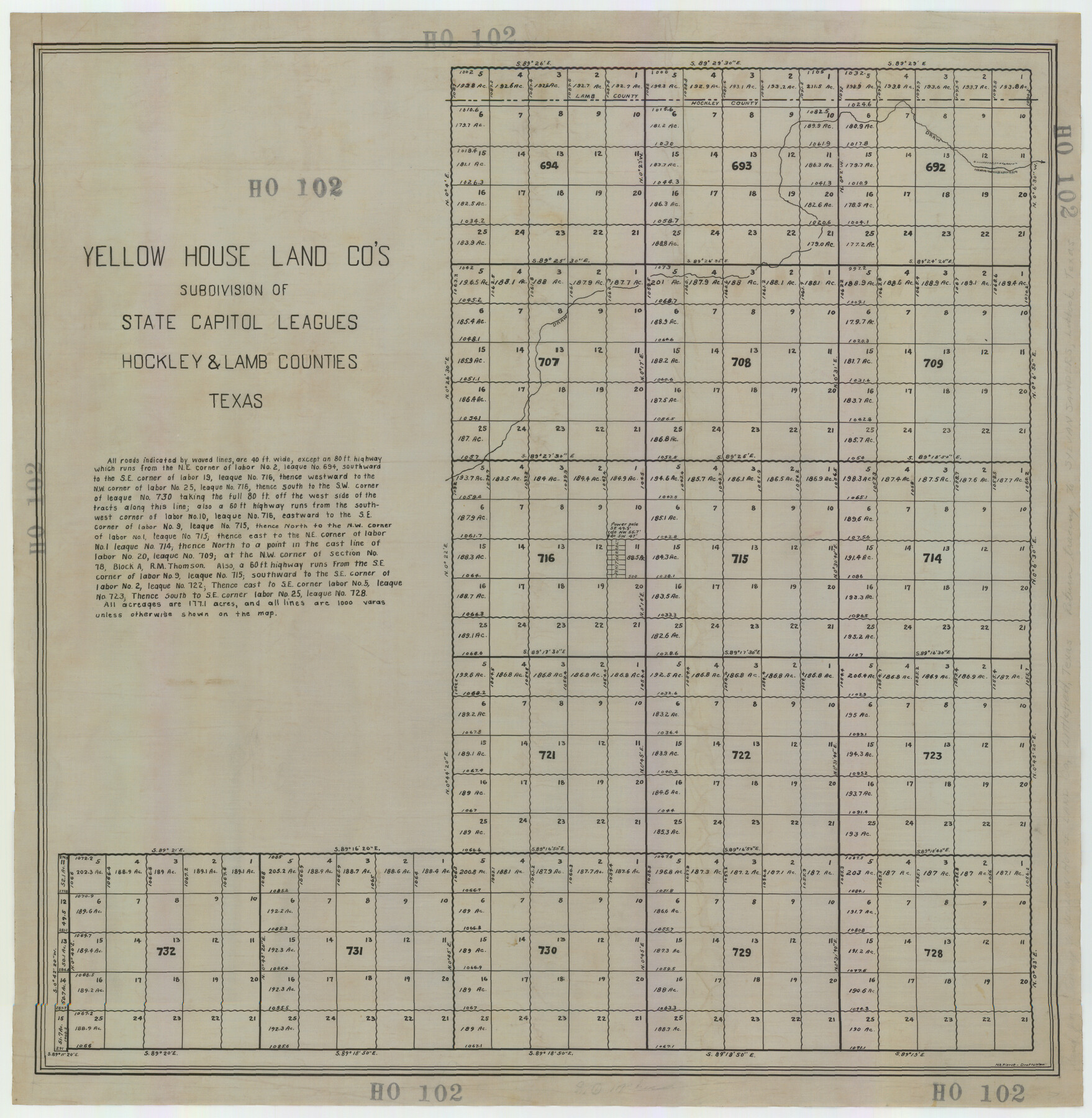
Yellow House Land Company's Subdivision of State Capitol Leagues Hockley and Lamb Counties, Texas
HO102
-
Map/Doc
92206
-
Collection
Twichell Survey Records
-
People and Organizations
M.A. Pierce (Draftsman)
-
Counties
Hockley Lamb
-
Height x Width
22.4 x 23.0 inches
56.9 x 58.4 cm
Part of: Twichell Survey Records
[Sketch showing conflict between G. C. & S. F. Ry. Co. Block 194 and State University Blocks 16 and 17]
![91627, [Sketch showing conflict between G. C. & S. F. Ry. Co. Block 194 and State University Blocks 16 and 17], Twichell Survey Records](https://historictexasmaps.com/wmedia_w700/maps/91627-1.tif.jpg)
Print $3.00
- Digital $50.00
[Sketch showing conflict between G. C. & S. F. Ry. Co. Block 194 and State University Blocks 16 and 17]
1900
Size 11.1 x 12.1 inches
Map/Doc 91627
Ellwood Ranch and Adjacent Property in Mitchell, Coke & Sterling Counties, Texas

Print $20.00
- Digital $50.00
Ellwood Ranch and Adjacent Property in Mitchell, Coke & Sterling Counties, Texas
1925
Size 17.6 x 27.8 inches
Map/Doc 91884
Map of Block X in the Name of Jesse F. Cross, Situated in Martin and Dawson Counties, Texas

Print $20.00
- Digital $50.00
Map of Block X in the Name of Jesse F. Cross, Situated in Martin and Dawson Counties, Texas
1908
Size 26.2 x 42.4 inches
Map/Doc 91356
Swisher Co. Texas

Print $20.00
- Digital $50.00
Swisher Co. Texas
1936
Size 36.8 x 38.0 inches
Map/Doc 89876
Rhoades Heights, North Part of West Half, Section 8, Block E

Print $20.00
- Digital $50.00
Rhoades Heights, North Part of West Half, Section 8, Block E
Size 29.2 x 13.5 inches
Map/Doc 92759
[Blks. B9, J, D19, John Walker]
![90480, [Blks. B9, J, D19, John Walker], Twichell Survey Records](https://historictexasmaps.com/wmedia_w700/maps/90480-1.tif.jpg)
Print $20.00
- Digital $50.00
[Blks. B9, J, D19, John Walker]
Size 28.6 x 15.9 inches
Map/Doc 90480
A Part of Blocks 31 and 32 Township 5 North

Print $20.00
- Digital $50.00
A Part of Blocks 31 and 32 Township 5 North
Size 19.6 x 23.8 inches
Map/Doc 92458
[Surveys to the North and West of the Francis Blundell survey containing townsite]
![90884, [Surveys to the North and West of the Francis Blundell survey containing townsite], Twichell Survey Records](https://historictexasmaps.com/wmedia_w700/maps/90884-1.tif.jpg)
Print $20.00
- Digital $50.00
[Surveys to the North and West of the Francis Blundell survey containing townsite]
Size 26.3 x 19.8 inches
Map/Doc 90884
Conway, Carson County, Texas

Print $20.00
- Digital $50.00
Conway, Carson County, Texas
Size 17.2 x 22.3 inches
Map/Doc 90227
Subdivision Map of Floyd County School Land Situated in Bailey County, Texas

Print $20.00
- Digital $50.00
Subdivision Map of Floyd County School Land Situated in Bailey County, Texas
Size 20.5 x 25.1 inches
Map/Doc 92530
Map of the Northeast Part of the Pitchfork Ranch

Print $20.00
- Digital $50.00
Map of the Northeast Part of the Pitchfork Ranch
1916
Size 23.4 x 23.4 inches
Map/Doc 90980
Town of Ropes Hockley County, Texas

Print $20.00
- Digital $50.00
Town of Ropes Hockley County, Texas
Size 29.3 x 28.7 inches
Map/Doc 92222
You may also like
Dallas County Sketch File 23

Print $6.00
- Digital $50.00
Dallas County Sketch File 23
1860
Size 14.5 x 8.8 inches
Map/Doc 20456
[Surveys along the Trinity River]
![350, [Surveys along the Trinity River], General Map Collection](https://historictexasmaps.com/wmedia_w700/maps/350.tif.jpg)
Print $20.00
- Digital $50.00
[Surveys along the Trinity River]
1846
Size 12.6 x 14.7 inches
Map/Doc 350
Crockett County Working Sketch 69

Print $20.00
- Digital $50.00
Crockett County Working Sketch 69
1962
Size 34.8 x 45.5 inches
Map/Doc 68402
Culberson County Sketch File 11a

Print $4.00
- Digital $50.00
Culberson County Sketch File 11a
1926
Size 14.3 x 8.7 inches
Map/Doc 20172
Hamilton County Working Sketch 16

Print $40.00
- Digital $50.00
Hamilton County Working Sketch 16
1950
Size 48.0 x 40.6 inches
Map/Doc 63354
Navarro County Sketch File 18

Print $3.00
- Digital $50.00
Navarro County Sketch File 18
1871
Size 10.6 x 10.0 inches
Map/Doc 32335
Hood County Sketch File 16

Print $4.00
- Digital $50.00
Hood County Sketch File 16
1860
Size 10.2 x 8.2 inches
Map/Doc 26597
Wichita County Sketch File 3

Print $8.00
- Digital $50.00
Wichita County Sketch File 3
1856
Size 7.2 x 16.3 inches
Map/Doc 40033
Wilson County Boundary File 1

Print $58.00
- Digital $50.00
Wilson County Boundary File 1
Size 9.6 x 4.5 inches
Map/Doc 60058
Brewster County Sketch File S-29a

Print $4.00
- Digital $50.00
Brewster County Sketch File S-29a
1972
Size 9.1 x 14.5 inches
Map/Doc 15848
Kimble County Working Sketch 66

Print $20.00
- Digital $50.00
Kimble County Working Sketch 66
1965
Size 31.1 x 27.2 inches
Map/Doc 70134
[WWI Topographic Planning Map of the Ardennes]
![94129, [WWI Topographic Planning Map of the Ardennes], Non-GLO Digital Images](https://historictexasmaps.com/wmedia_w700/maps/94129-1.tif.jpg)
Print $20.00
[WWI Topographic Planning Map of the Ardennes]
1918
Size 35.8 x 20.2 inches
Map/Doc 94129