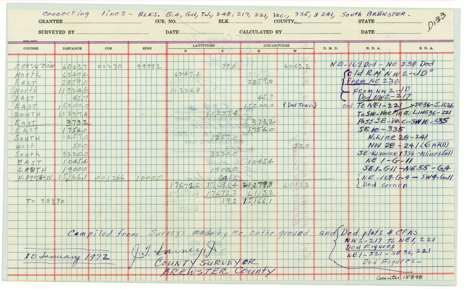
Brewster County Sketch File S-29a
[Connecting lines in multiple Blocks in south Brewster County regarding mining claims in section 4, Block G-11]
-
Map/Doc
15848
-
Collection
General Map Collection
-
Object Dates
1972/1/10 (Creation Date)
1972/1/12 (File Date)
-
People and Organizations
J.T. Carney, Jr. (Surveyor/Engineer)
-
Counties
Brewster
-
Subjects
Surveying Sketch File
-
Height x Width
9.1 x 14.5 inches
23.1 x 36.8 cm
-
Medium
paper, manuscript
Part of: General Map Collection
Briscoe County Sketch File D

Print $40.00
- Digital $50.00
Briscoe County Sketch File D
1918
Size 25.8 x 22.9 inches
Map/Doc 11001
University Land Loving-Ward-Winkler Counties

Print $20.00
- Digital $50.00
University Land Loving-Ward-Winkler Counties
1931
Size 24.7 x 33.2 inches
Map/Doc 2448
Crockett County Sketch File 12

Print $20.00
- Digital $50.00
Crockett County Sketch File 12
Size 26.8 x 18.9 inches
Map/Doc 11216
Polk County Working Sketch 15

Print $20.00
- Digital $50.00
Polk County Working Sketch 15
1947
Size 27.4 x 32.4 inches
Map/Doc 71630
Menard County Rolled Sketch 18

Print $20.00
- Digital $50.00
Menard County Rolled Sketch 18
2024
Size 35.9 x 47.7 inches
Map/Doc 97427
Montague County Working Sketch 25

Print $20.00
- Digital $50.00
Montague County Working Sketch 25
1955
Size 42.4 x 28.4 inches
Map/Doc 71091
McMullen County Sketch File 10

Print $40.00
- Digital $50.00
McMullen County Sketch File 10
1876
Size 14.3 x 17.6 inches
Map/Doc 31353
El Paso County Boundary File 21

Print $6.00
- Digital $50.00
El Paso County Boundary File 21
Size 15.1 x 9.5 inches
Map/Doc 53214
Map of Hill County

Print $20.00
- Digital $50.00
Map of Hill County
1884
Size 47.2 x 36.8 inches
Map/Doc 16851
Runnels County Sketch File 31

Print $6.00
Runnels County Sketch File 31
1950
Size 11.5 x 8.8 inches
Map/Doc 35496
Red River County Working Sketch 63

Print $20.00
- Digital $50.00
Red River County Working Sketch 63
1973
Size 43.6 x 37.0 inches
Map/Doc 72046
Map of section no. 10 of a survey of Padre Island made for the Office of the Attorney General of the State of Texas

Print $40.00
- Digital $50.00
Map of section no. 10 of a survey of Padre Island made for the Office of the Attorney General of the State of Texas
1941
Size 57.2 x 40.6 inches
Map/Doc 2266
You may also like
Pecos County Rolled Sketch 124

Print $20.00
- Digital $50.00
Pecos County Rolled Sketch 124
Size 22.8 x 18.8 inches
Map/Doc 7265
Galveston County Sketch File 43

Print $40.00
- Digital $50.00
Galveston County Sketch File 43
1915
Size 19.4 x 15.1 inches
Map/Doc 11539
Maverick County Sketch File 27

Print $6.00
- Digital $50.00
Maverick County Sketch File 27
1873
Size 9.9 x 8.0 inches
Map/Doc 31160
Montgomery Co.

Print $40.00
- Digital $50.00
Montgomery Co.
1943
Size 44.4 x 54.1 inches
Map/Doc 73244
Terrell County Working Sketch 51

Print $40.00
- Digital $50.00
Terrell County Working Sketch 51
1958
Size 63.7 x 43.6 inches
Map/Doc 62144

Kent County Working Sketch 20

Print $40.00
- Digital $50.00
Kent County Working Sketch 20
1980
Size 50.7 x 44.1 inches
Map/Doc 70027
Flight Mission No. BRA-3M, Frame 129, Jefferson County

Print $20.00
- Digital $50.00
Flight Mission No. BRA-3M, Frame 129, Jefferson County
1953
Size 18.5 x 22.3 inches
Map/Doc 85403

Haskell County Rolled Sketch 2

Print $20.00
- Digital $50.00
Haskell County Rolled Sketch 2
1902
Size 34.5 x 27.1 inches
Map/Doc 6163
Amended Plat New Hobbs Addition to New Hobbs, Lea County, New Mexico

Print $20.00
- Digital $50.00
Amended Plat New Hobbs Addition to New Hobbs, Lea County, New Mexico
Size 24.1 x 18.5 inches
Map/Doc 92418
Beales and Royuela Empresario Colony. March 14, 1832

Print $20.00
Beales and Royuela Empresario Colony. March 14, 1832
2020
Size 19.4 x 21.6 inches
Map/Doc 95984