Menard County Rolled Sketch 18
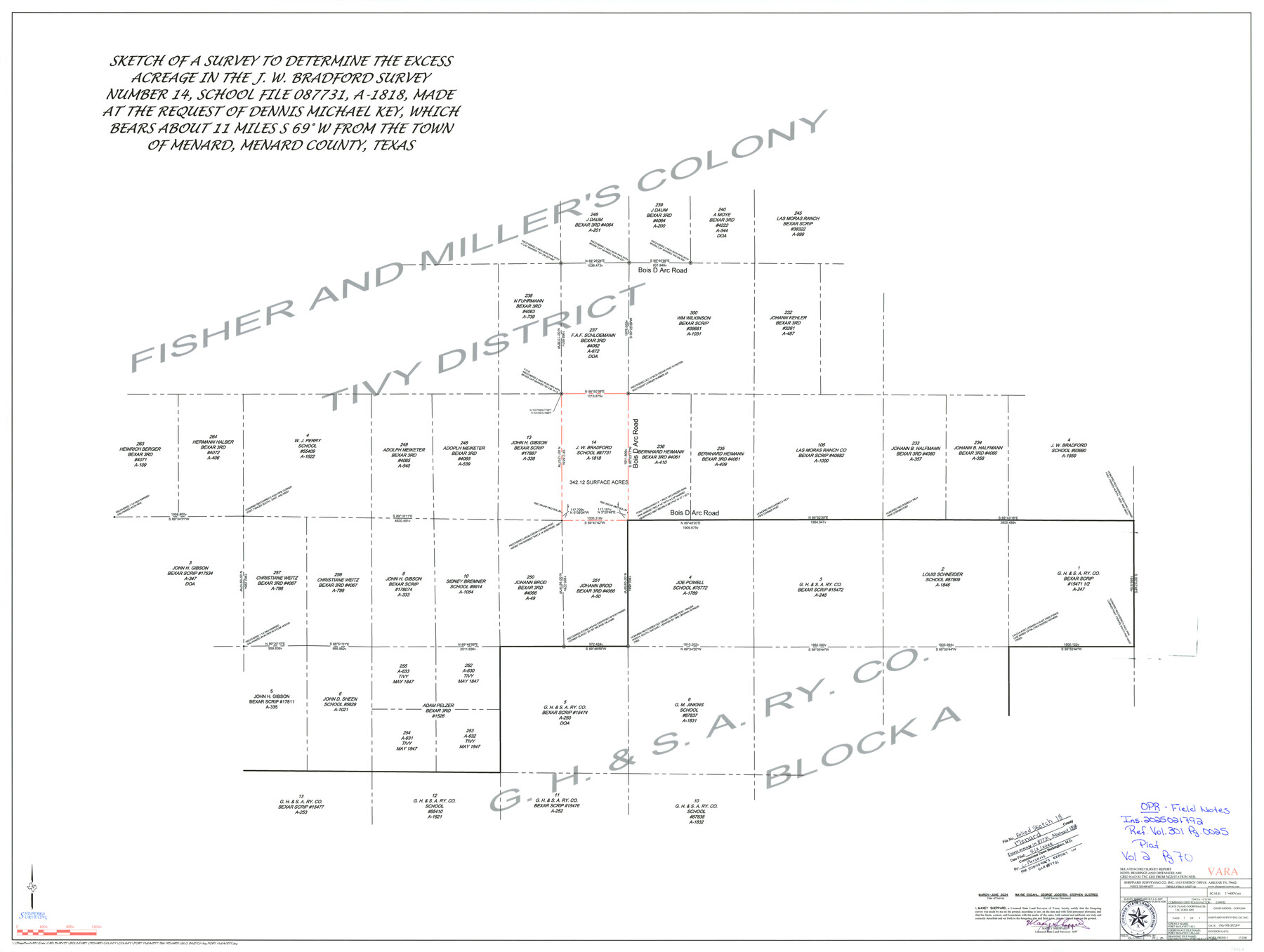
Sketch of a survey to determine the excess acreage in the J.W. Bradford Survey Number 14, School File 087731, A-1818, made at the request of Dennis Michael Key
-
Map/Doc
97427
-
Collection
General Map Collection
-
Object Dates
6/18/2024 (Creation Date)
5/2/2025 (File Date)
3-6/2024 (Survey Date)
-
People and Organizations
Maxey Sheppard (Surveyor/Engineer)
-
Counties
Menard
-
Subjects
Surveying Rolled Sketch
-
Height x Width
35.9 x 47.7 inches
91.2 x 121.2 cm
-
Scale
1" = 400 varas
-
Comments
For surveyor's report see School File 87731.
Part of: General Map Collection
San Saba County Sketch File 14c

Print $40.00
- Digital $50.00
San Saba County Sketch File 14c
1894
Size 17.3 x 14.4 inches
Map/Doc 36452
Val Verde County Sketch File C

Print $62.00
- Digital $50.00
Val Verde County Sketch File C
1898
Size 15.5 x 19.8 inches
Map/Doc 12545
Wood County Working Sketch 3

Print $2.00
- Digital $50.00
Wood County Working Sketch 3
1916
Size 9.8 x 8.4 inches
Map/Doc 62003
Flight Mission No. DQN-6K, Frame 93, Calhoun County

Print $20.00
- Digital $50.00
Flight Mission No. DQN-6K, Frame 93, Calhoun County
1953
Size 18.4 x 22.1 inches
Map/Doc 84453
San Patricio County Rolled Sketch 29A

Print $20.00
- Digital $50.00
San Patricio County Rolled Sketch 29A
1934
Size 37.7 x 45.7 inches
Map/Doc 9895
Galveston County NRC Article 33.136 Sketch 82

Print $82.00
- Digital $50.00
Galveston County NRC Article 33.136 Sketch 82
2015
Size 24.0 x 36.0 inches
Map/Doc 94601
Map of Surveys Made for the T&PRR in Andrews & Martin Counties, Blocks 37, 38, 39, 40 & 41, Reserve West of the Colorado River

Print $20.00
- Digital $50.00
Map of Surveys Made for the T&PRR in Andrews & Martin Counties, Blocks 37, 38, 39, 40 & 41, Reserve West of the Colorado River
1876
Size 42.0 x 36.8 inches
Map/Doc 2229
Chambers County Working Sketch 19

Print $20.00
- Digital $50.00
Chambers County Working Sketch 19
1965
Size 23.5 x 25.8 inches
Map/Doc 68002
Leon County Sketch File 24

Print $70.00
- Digital $50.00
Leon County Sketch File 24
1932
Size 11.2 x 8.7 inches
Map/Doc 29781
Flight Mission No. CRK-7P, Frame 25, Refugio County

Print $20.00
- Digital $50.00
Flight Mission No. CRK-7P, Frame 25, Refugio County
1956
Size 18.6 x 22.3 inches
Map/Doc 86945
Rusk County Working Sketch 28

Print $20.00
- Digital $50.00
Rusk County Working Sketch 28
1934
Size 24.2 x 18.3 inches
Map/Doc 63664
Outer Continental Shelf Leasing Maps (Louisiana Offshore Operations)

Print $20.00
- Digital $50.00
Outer Continental Shelf Leasing Maps (Louisiana Offshore Operations)
1959
Size 21.4 x 13.9 inches
Map/Doc 76099
You may also like
Montague County Rolled Sketch 7

Print $20.00
- Digital $50.00
Montague County Rolled Sketch 7
1964
Size 17.8 x 22.9 inches
Map/Doc 6791
Panola County Rolled Sketch 2

Print $20.00
- Digital $50.00
Panola County Rolled Sketch 2
1944
Size 20.7 x 27.0 inches
Map/Doc 7197
Briscoe County Working Sketch 11

Print $20.00
- Digital $50.00
Briscoe County Working Sketch 11
1982
Size 27.5 x 24.3 inches
Map/Doc 67814
Val Verde County Sketch File 7

Print $6.00
- Digital $50.00
Val Verde County Sketch File 7
1877
Size 16.9 x 9.7 inches
Map/Doc 39196
Nueces County Sketch File 42

Print $24.00
- Digital $50.00
Nueces County Sketch File 42
1950
Size 11.0 x 8.6 inches
Map/Doc 32633
[Rand McNally's Indexed Map of Texas and Indian Territory]
![93992, [Rand McNally's Indexed Map of Texas and Indian Territory], Rees-Jones Digital Map Collection](https://historictexasmaps.com/wmedia_w700/maps/93992.tif.jpg)
Print $20.00
- Digital $50.00
[Rand McNally's Indexed Map of Texas and Indian Territory]
Size 26.0 x 20.6 inches
Map/Doc 93992
Presidio County Rolled Sketch 129

Print $20.00
- Digital $50.00
Presidio County Rolled Sketch 129
1989
Size 27.0 x 46.0 inches
Map/Doc 7399
[Sketch for Mineral Application 24072, San Jacinto River]
![65589, [Sketch for Mineral Application 24072, San Jacinto River], General Map Collection](https://historictexasmaps.com/wmedia_w700/maps/65589.tif.jpg)
Print $20.00
- Digital $50.00
[Sketch for Mineral Application 24072, San Jacinto River]
1929
Size 29.6 x 14.7 inches
Map/Doc 65589
Jasper County Rolled Sketch 9

Print $83.00
- Digital $50.00
Jasper County Rolled Sketch 9
1932
Size 10.7 x 15.4 inches
Map/Doc 46171
General Highway Map, Polk County, Texas

Print $20.00
General Highway Map, Polk County, Texas
1961
Size 18.2 x 24.4 inches
Map/Doc 79629
Blanco County Sketch File 39

Print $4.00
- Digital $50.00
Blanco County Sketch File 39
Size 8.6 x 13.9 inches
Map/Doc 14650
No. 2 Chart of Corpus Christi Pass, Texas

Print $20.00
- Digital $50.00
No. 2 Chart of Corpus Christi Pass, Texas
1878
Size 18.3 x 27.4 inches
Map/Doc 73018