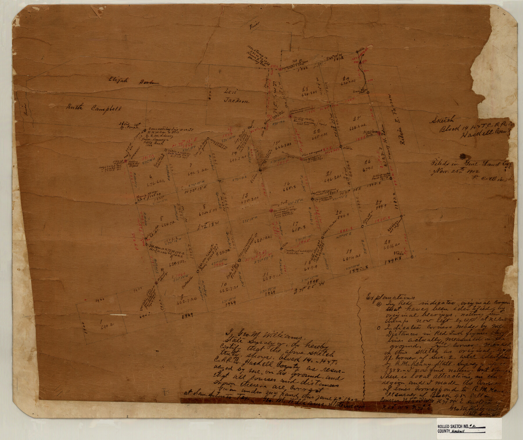
Haskell County Rolled Sketch 2
Resurvey of Block 14, H. & T. C. R.R. Co., Haskell County, Texas
-
Map/Doc
6163
-
Collection
General Map Collection
-
Object Dates
6/23/1902 (Creation Date)
11/25/1902 (File Date)
-
People and Organizations
Geo. M. Williams (Surveyor/Engineer)
-
Counties
Haskell
-
Subjects
Surveying Rolled Sketch
-
Height x Width
34.5 x 27.1 inches
87.6 x 68.8 cm
Part of: General Map Collection
Flight Mission No. BRA-7M, Frame 41, Jefferson County

Print $20.00
- Digital $50.00
Flight Mission No. BRA-7M, Frame 41, Jefferson County
1953
Size 18.6 x 22.3 inches
Map/Doc 85492
Falls County Sketch File 20

Print $12.00
- Digital $50.00
Falls County Sketch File 20
1869
Size 10.0 x 8.3 inches
Map/Doc 22388
Jefferson County NRC Article 33.136 Sketch 1

Print $20.00
- Digital $50.00
Jefferson County NRC Article 33.136 Sketch 1
2002
Size 24.0 x 36.1 inches
Map/Doc 61601
Hutchinson County Sketch File 2

Print $8.00
- Digital $50.00
Hutchinson County Sketch File 2
1882
Size 14.2 x 8.7 inches
Map/Doc 27173
Presidio County Rolled Sketch S2

Print $20.00
- Digital $50.00
Presidio County Rolled Sketch S2
1916
Size 14.2 x 12.0 inches
Map/Doc 7415
Bee County Boundary File 6

Print $4.00
- Digital $50.00
Bee County Boundary File 6
Size 10.4 x 7.9 inches
Map/Doc 50458
Guadalupe County Sketch File 6

Print $6.00
- Digital $50.00
Guadalupe County Sketch File 6
1873
Size 9.7 x 12.3 inches
Map/Doc 24666
Lamar County Sketch File 15

Print $134.00
- Digital $50.00
Lamar County Sketch File 15
1989
Size 14.5 x 9.1 inches
Map/Doc 29310
Maps of Gulf Intracoastal Waterway, Texas - Sabine River to the Rio Grande and connecting waterways including ship channels

Print $20.00
- Digital $50.00
Maps of Gulf Intracoastal Waterway, Texas - Sabine River to the Rio Grande and connecting waterways including ship channels
1966
Size 14.4 x 20.6 inches
Map/Doc 61996
Rusk County Working Sketch 7

Print $20.00
- Digital $50.00
Rusk County Working Sketch 7
1982
Size 22.3 x 36.7 inches
Map/Doc 63642
Wichita County Rolled Sketch 18

Print $20.00
- Digital $50.00
Wichita County Rolled Sketch 18
1923
Size 25.7 x 38.0 inches
Map/Doc 8254
Kinney County Sketch File 5

Print $2.00
- Digital $50.00
Kinney County Sketch File 5
Size 5.7 x 13.1 inches
Map/Doc 29123
You may also like
Flight Mission No. DCL-6C, Frame 173, Kenedy County

Print $20.00
- Digital $50.00
Flight Mission No. DCL-6C, Frame 173, Kenedy County
1943
Size 18.6 x 22.4 inches
Map/Doc 85985
San Jacinto County Sketch File 5

Print $2.00
San Jacinto County Sketch File 5
1848
Size 8.1 x 14.5 inches
Map/Doc 35702
San Luis Pass to East Matagorda Bay

Print $20.00
- Digital $50.00
San Luis Pass to East Matagorda Bay
1957
Size 34.9 x 46.9 inches
Map/Doc 69962
Webb County Sketch File B1

Print $20.00
- Digital $50.00
Webb County Sketch File B1
Size 16.9 x 26.4 inches
Map/Doc 12606
No. 3 Chart of Channel connecting Corpus Christi Bay with Aransas Bay, Texas

Print $20.00
- Digital $50.00
No. 3 Chart of Channel connecting Corpus Christi Bay with Aransas Bay, Texas
1878
Size 18.3 x 27.5 inches
Map/Doc 72784
![90513, [Capitol Lands], Twichell Survey Records](https://historictexasmaps.com/wmedia_w700/maps/90513-1.tif.jpg)
Edwards County Sketch File 6

Print $20.00
- Digital $50.00
Edwards County Sketch File 6
1880
Size 11.7 x 19.6 inches
Map/Doc 11419
Walker County Working Sketch 14

Print $40.00
- Digital $50.00
Walker County Working Sketch 14
1958
Size 19.8 x 51.0 inches
Map/Doc 72294
General Highway Map, Hutchinson County, Texas

Print $20.00
General Highway Map, Hutchinson County, Texas
1961
Size 18.1 x 24.6 inches
Map/Doc 79529
1968 Texas Official State Highway Map

Digital $50.00
1968 Texas Official State Highway Map
Size 28.1 x 36.5 inches
Map/Doc 94319
Stephens County Working Sketch 39

Print $20.00
- Digital $50.00
Stephens County Working Sketch 39
1995
Size 25.5 x 27.1 inches
Map/Doc 63982
Hutchinson County Working Sketch 31

Print $20.00
- Digital $50.00
Hutchinson County Working Sketch 31
1978
Size 27.0 x 22.2 inches
Map/Doc 66391