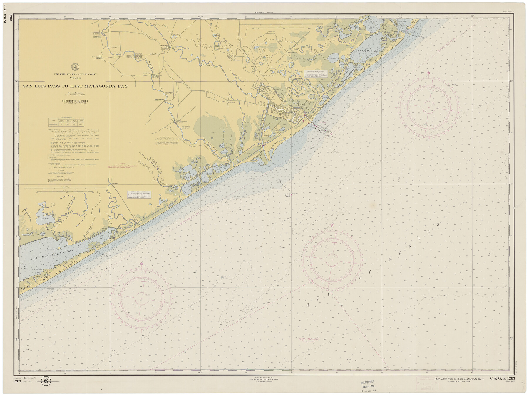
San Luis Pass to East Matagorda Bay
K-6-1283d
-
Map/Doc
69962
-
Collection
General Map Collection
-
Object Dates
1/21/1957 (Creation Date)
-
Counties
Galveston Matagorda Brazoria
-
Subjects
Nautical Charts
-
Height x Width
34.9 x 46.9 inches
88.7 x 119.1 cm
Part of: General Map Collection
Outer Continental Shelf Leasing Maps (Louisiana Offshore Operations)

Print $20.00
- Digital $50.00
Outer Continental Shelf Leasing Maps (Louisiana Offshore Operations)
1959
Size 17.7 x 13.9 inches
Map/Doc 76108
Cherokee County Working Sketch Graphic Index

Print $40.00
- Digital $50.00
Cherokee County Working Sketch Graphic Index
1933
Size 56.7 x 40.0 inches
Map/Doc 76492
Coke County Rolled Sketch 1

Print $20.00
- Digital $50.00
Coke County Rolled Sketch 1
1943
Size 26.9 x 21.6 inches
Map/Doc 5503
Ward County State of Texas

Print $20.00
- Digital $50.00
Ward County State of Texas
1888
Size 22.6 x 26.0 inches
Map/Doc 4641
Brazoria County Sketch File 32

Print $60.00
- Digital $50.00
Brazoria County Sketch File 32
1896
Size 14.1 x 16.2 inches
Map/Doc 10955
Baylor County Sketch File A5

Print $6.00
- Digital $50.00
Baylor County Sketch File A5
Size 10.4 x 8.8 inches
Map/Doc 14088
San Patricio County Rolled Sketch 7A

Print $20.00
- Digital $50.00
San Patricio County Rolled Sketch 7A
1870
Size 46.8 x 27.3 inches
Map/Doc 9884
San Saba County Sketch File 6

Print $6.00
- Digital $50.00
San Saba County Sketch File 6
1881
Size 10.9 x 8.4 inches
Map/Doc 36414
Flight Mission No. BRE-1P, Frame 143, Nueces County

Print $20.00
- Digital $50.00
Flight Mission No. BRE-1P, Frame 143, Nueces County
1956
Size 18.3 x 22.2 inches
Map/Doc 86703
Flight Mission No. DAG-18K, Frame 74, Matagorda County

Print $20.00
- Digital $50.00
Flight Mission No. DAG-18K, Frame 74, Matagorda County
1952
Size 18.5 x 22.4 inches
Map/Doc 86367
Anderson County Sketch File 4

Print $6.00
- Digital $50.00
Anderson County Sketch File 4
Size 8.7 x 6.4 inches
Map/Doc 12743
Map of Freeport, Brazoria County, Texas

Print $20.00
- Digital $50.00
Map of Freeport, Brazoria County, Texas
Size 27.0 x 39.1 inches
Map/Doc 7689
You may also like
Lee County Working Sketch 6

Print $20.00
- Digital $50.00
Lee County Working Sketch 6
1975
Size 39.7 x 36.3 inches
Map/Doc 70385
Edwards County Working Sketch 63

Print $20.00
- Digital $50.00
Edwards County Working Sketch 63
1955
Size 32.5 x 46.4 inches
Map/Doc 68939
El Paso County Rolled Sketch 16

Print $40.00
- Digital $50.00
El Paso County Rolled Sketch 16
1885
Size 21.5 x 52.0 inches
Map/Doc 8855
Liberty County Sketch File 20

Print $6.00
- Digital $50.00
Liberty County Sketch File 20
Size 7.8 x 9.9 inches
Map/Doc 29925
Fisher County Working Sketch 7

Print $20.00
- Digital $50.00
Fisher County Working Sketch 7
1944
Size 36.7 x 28.9 inches
Map/Doc 69141
[B. S. & F. Blk. M10, D. & S. E. RR. Co. Secs. 138 thru 149]
![90133, [B. S. & F. Blk. M10, D. & S. E. RR. Co. Secs. 138 thru 149], Twichell Survey Records](https://historictexasmaps.com/wmedia_w700/maps/90133-1.tif.jpg)
Print $20.00
- Digital $50.00
[B. S. & F. Blk. M10, D. & S. E. RR. Co. Secs. 138 thru 149]
Size 26.4 x 15.5 inches
Map/Doc 90133
Galveston County NRC Article 33.136 Sketch 33

Print $20.00
- Digital $50.00
Galveston County NRC Article 33.136 Sketch 33
2003
Size 42.5 x 30.9 inches
Map/Doc 83285
[Terry County Highways]
![92905, [Terry County Highways], Twichell Survey Records](https://historictexasmaps.com/wmedia_w700/maps/92905-1.tif.jpg)
Print $20.00
- Digital $50.00
[Terry County Highways]
Size 17.0 x 16.8 inches
Map/Doc 92905
Zapata County Working Sketch 10

Print $20.00
- Digital $50.00
Zapata County Working Sketch 10
1954
Size 33.9 x 32.2 inches
Map/Doc 62061
Burleson County Working Sketch 17

Print $20.00
- Digital $50.00
Burleson County Working Sketch 17
1980
Size 20.5 x 37.6 inches
Map/Doc 67736
Webb County Rolled Sketch 5

Print $20.00
- Digital $50.00
Webb County Rolled Sketch 5
Size 43.2 x 23.0 inches
Map/Doc 8172
Harris County Sketch File 90

Print $46.00
- Digital $50.00
Harris County Sketch File 90
1967
Size 12.2 x 14.4 inches
Map/Doc 25596