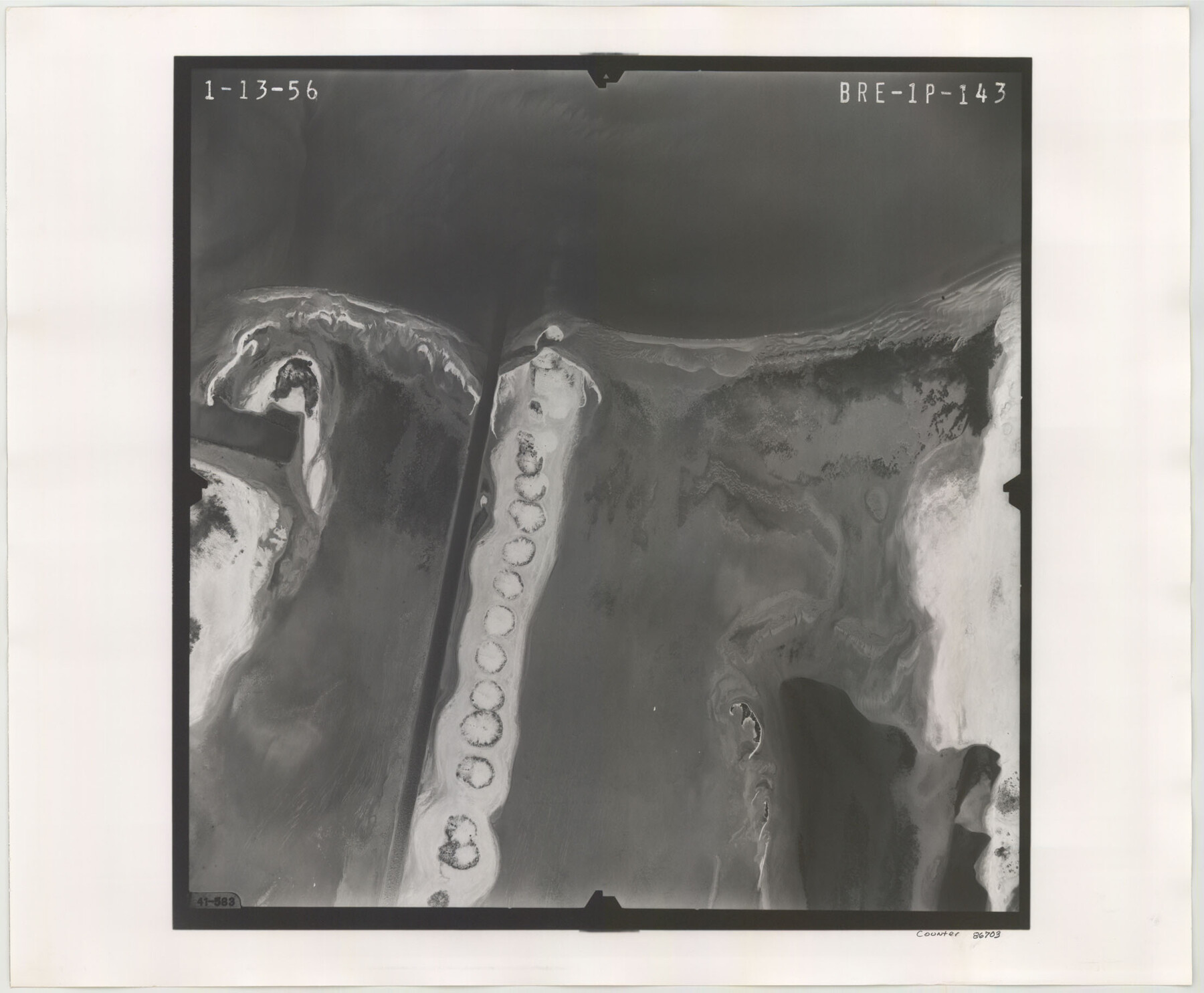
Flight Mission No. BRE-1P, Frame 143, Nueces County
BRE-1P-143
-
Map/Doc
86703
-
Collection
General Map Collection
-
Object Dates
1956/1/13 (Creation Date)
-
People and Organizations
U. S. Department of Agriculture (Publisher)
-
Counties
Nueces
-
Subjects
Aerial Photograph
-
Height x Width
18.3 x 22.2 inches
46.5 x 56.4 cm
-
Comments
Flown by V. L. Beavers and Associates of San Antonio, Texas.
Part of: General Map Collection
Moore County Working Sketch 8

Print $20.00
- Digital $50.00
Moore County Working Sketch 8
1948
Size 23.2 x 31.8 inches
Map/Doc 71190
St. L. S.-W. Ry. of Texas, Map of Lufkin Branch in Smith County, Texas

Print $40.00
- Digital $50.00
St. L. S.-W. Ry. of Texas, Map of Lufkin Branch in Smith County, Texas
1912
Size 24.3 x 122.9 inches
Map/Doc 64692
Gray County Sketch File 12

Print $6.00
- Digital $50.00
Gray County Sketch File 12
1889
Size 17.0 x 8.3 inches
Map/Doc 24454
Stephens County Boundary File 2

Print $34.00
- Digital $50.00
Stephens County Boundary File 2
Size 14.2 x 8.7 inches
Map/Doc 58866
Willacy County Rolled Sketch 2

Print $40.00
- Digital $50.00
Willacy County Rolled Sketch 2
1921
Size 30.7 x 62.9 inches
Map/Doc 10145
Parker County Sketch File 17

Print $6.00
- Digital $50.00
Parker County Sketch File 17
Size 10.7 x 9.5 inches
Map/Doc 33552
Map of Wharton County

Print $20.00
- Digital $50.00
Map of Wharton County
1865
Size 24.9 x 26.9 inches
Map/Doc 4136
Current Miscellaneous File 76

Print $10.00
- Digital $50.00
Current Miscellaneous File 76
1960
Size 11.3 x 8.8 inches
Map/Doc 74189
Reagan County Working Sketch 23

Print $40.00
- Digital $50.00
Reagan County Working Sketch 23
1957
Size 25.0 x 60.1 inches
Map/Doc 71865
Flight Mission No. DQN-1K, Frame 123, Calhoun County

Print $20.00
- Digital $50.00
Flight Mission No. DQN-1K, Frame 123, Calhoun County
1953
Size 18.4 x 22.2 inches
Map/Doc 84189
Pecos County Rolled Sketch 56

Print $20.00
- Digital $50.00
Pecos County Rolled Sketch 56
1916
Size 18.1 x 24.2 inches
Map/Doc 5229
[Surveys along Seco, Pecan and Deer Creeks]
![316, [Surveys along Seco, Pecan and Deer Creeks], General Map Collection](https://historictexasmaps.com/wmedia_w700/maps/316.tif.jpg)
Print $2.00
- Digital $50.00
[Surveys along Seco, Pecan and Deer Creeks]
1847
Size 8.9 x 7.8 inches
Map/Doc 316
You may also like
Bexar County Rolled Sketch 3

Print $20.00
- Digital $50.00
Bexar County Rolled Sketch 3
1873
Size 25.5 x 18.0 inches
Map/Doc 5136
Pecos County Working Sketch 21
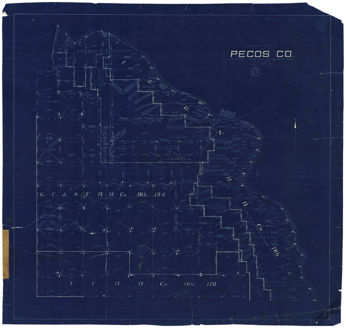
Print $20.00
- Digital $50.00
Pecos County Working Sketch 21
1925
Size 27.3 x 29.0 inches
Map/Doc 71491
General Highway Map, Freestone County, Texas

Print $20.00
General Highway Map, Freestone County, Texas
1961
Size 18.1 x 24.8 inches
Map/Doc 79472
Hutchinson County Working Sketch 8

Print $20.00
- Digital $50.00
Hutchinson County Working Sketch 8
1919
Size 24.8 x 16.7 inches
Map/Doc 66366
Ochiltree County Boundary File 3

Print $10.00
- Digital $50.00
Ochiltree County Boundary File 3
Size 11.2 x 8.6 inches
Map/Doc 57677
Nueces County Rolled Sketch 24

Print $20.00
- Digital $50.00
Nueces County Rolled Sketch 24
Size 19.6 x 24.8 inches
Map/Doc 6873
Crockett County Sketch File 69

Print $6.00
- Digital $50.00
Crockett County Sketch File 69
1931
Size 14.5 x 8.9 inches
Map/Doc 19855
Gregg County Rolled Sketch 17

Print $20.00
- Digital $50.00
Gregg County Rolled Sketch 17
1933
Size 14.2 x 27.5 inches
Map/Doc 6041
Flight Mission No. BRE-5P, Frame 199, Nueces County

Print $20.00
- Digital $50.00
Flight Mission No. BRE-5P, Frame 199, Nueces County
1956
Size 18.4 x 22.3 inches
Map/Doc 86839
Kenedy County Working Sketch 3

Print $20.00
- Digital $50.00
Kenedy County Working Sketch 3
1903
Size 30.3 x 38.4 inches
Map/Doc 70005
Knox County Rolled Sketch 14

Print $40.00
- Digital $50.00
Knox County Rolled Sketch 14
1892
Size 21.8 x 54.9 inches
Map/Doc 10666
Tarrant County Sketch File 27

Print $4.00
- Digital $50.00
Tarrant County Sketch File 27
Size 8.0 x 9.6 inches
Map/Doc 37741