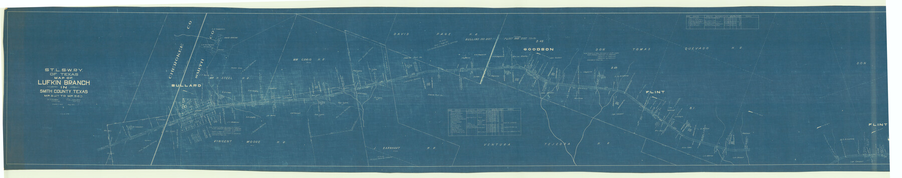
St. L. S.-W. Ry. of Texas, Map of Lufkin Branch in Smith County, Texas
M.P. 547 to M.P. 563
Z-2-195
-
Map/Doc
64692
-
Collection
General Map Collection
-
Object Dates
1912 (Creation Date)
-
People and Organizations
W.T. Eaton (Surveyor/Engineer)
T.G. Johnston (Surveyor/Engineer)
-
Counties
Smith Cherokee
-
Subjects
Railroads
-
Height x Width
24.3 x 122.9 inches
61.7 x 312.2 cm
-
Medium
blueprint/diazo
-
Scale
1" = 400'
-
Comments
See 64693 and 64694 for other sheets of this map.
-
Features
SLS
Flint
Goodson
Bullard
Part of: General Map Collection
Texas Gulf Coast Map from the Sabine River to the Rio Grande as subdivided for mineral development

Print $20.00
- Digital $50.00
Texas Gulf Coast Map from the Sabine River to the Rio Grande as subdivided for mineral development
1948
Size 45.0 x 39.9 inches
Map/Doc 2911
Flight Mission No. CRK-3P, Frame 178, Refugio County

Print $20.00
- Digital $50.00
Flight Mission No. CRK-3P, Frame 178, Refugio County
1956
Size 18.4 x 22.2 inches
Map/Doc 86925
Hansford County

Print $20.00
- Digital $50.00
Hansford County
1932
Size 39.6 x 38.5 inches
Map/Doc 77301
Wharton County Working Sketch 3

Print $20.00
- Digital $50.00
Wharton County Working Sketch 3
Size 17.5 x 16.4 inches
Map/Doc 72467
Harbor Pass and Bar at Brazos Santiago, Texas

Print $20.00
- Digital $50.00
Harbor Pass and Bar at Brazos Santiago, Texas
1871
Size 18.2 x 26.8 inches
Map/Doc 72983
Nueces County Rolled Sketch 11

Print $40.00
- Digital $50.00
Nueces County Rolled Sketch 11
Size 43.2 x 56.8 inches
Map/Doc 9586
Duval County Sketch File 65

Print $6.00
- Digital $50.00
Duval County Sketch File 65
1943
Size 14.4 x 9.1 inches
Map/Doc 21441
Louisiana and Texas Intracoastal Waterway

Print $20.00
- Digital $50.00
Louisiana and Texas Intracoastal Waterway
Size 13.9 x 19.0 inches
Map/Doc 83347
Bexar County Sketch File 40

Print $4.00
- Digital $50.00
Bexar County Sketch File 40
Size 8.4 x 7.0 inches
Map/Doc 14514
Comanche County Sketch File 5

Print $4.00
- Digital $50.00
Comanche County Sketch File 5
1848
Size 8.6 x 8.3 inches
Map/Doc 19059
Reeves County Sketch File 14

Print $4.00
- Digital $50.00
Reeves County Sketch File 14
1872
Size 8.0 x 12.7 inches
Map/Doc 35192
Flight Mission No. BRE-2P, Frame 99, Nueces County

Print $20.00
- Digital $50.00
Flight Mission No. BRE-2P, Frame 99, Nueces County
1956
Size 18.5 x 22.3 inches
Map/Doc 86784
You may also like
Travis County Working Sketch 8

Print $20.00
- Digital $50.00
Travis County Working Sketch 8
1917
Size 18.8 x 18.8 inches
Map/Doc 69392
General Land Office and State Reclamation Department - Topographic Sheets

Print $20.00
- Digital $50.00
General Land Office and State Reclamation Department - Topographic Sheets
1930
Size 26.2 x 16.7 inches
Map/Doc 65264
Liberty County Working Sketch 47

Print $20.00
- Digital $50.00
Liberty County Working Sketch 47
1954
Size 28.3 x 24.6 inches
Map/Doc 70506
Hays County Working Sketch 14

Print $20.00
- Digital $50.00
Hays County Working Sketch 14
1964
Size 23.7 x 19.7 inches
Map/Doc 66088
Map and Profile of the Denison and Pacific Railway from Denison to Whitesboro

Print $40.00
- Digital $50.00
Map and Profile of the Denison and Pacific Railway from Denison to Whitesboro
1878
Size 42.5 x 57.5 inches
Map/Doc 64284
Freestone County State Real Property Sketch 1

Print $20.00
- Digital $50.00
Freestone County State Real Property Sketch 1
1997
Size 24.3 x 35.2 inches
Map/Doc 80128
Flight Mission No. CRC-4R, Frame 71, Chambers County

Print $20.00
- Digital $50.00
Flight Mission No. CRC-4R, Frame 71, Chambers County
1956
Size 18.7 x 22.5 inches
Map/Doc 84875
Guadalupe County Sketch File 21

Print $6.00
- Digital $50.00
Guadalupe County Sketch File 21
Size 9.9 x 8.5 inches
Map/Doc 24702
Edwards County Working Sketch 3

Print $20.00
- Digital $50.00
Edwards County Working Sketch 3
Size 22.6 x 18.3 inches
Map/Doc 68879
[Portion of sketch showing alleged vacancy]
![91953, [Portion of sketch showing alleged vacancy], Twichell Survey Records](https://historictexasmaps.com/wmedia_w700/maps/91953-1.tif.jpg)
Print $20.00
- Digital $50.00
[Portion of sketch showing alleged vacancy]
Size 18.9 x 24.4 inches
Map/Doc 91953
Tom Green County Sketch File 50

Print $20.00
- Digital $50.00
Tom Green County Sketch File 50
1884
Size 25.4 x 34.5 inches
Map/Doc 12442
Scurry County Rolled Sketch 11

Print $20.00
- Digital $50.00
Scurry County Rolled Sketch 11
Size 20.2 x 16.8 inches
Map/Doc 7771