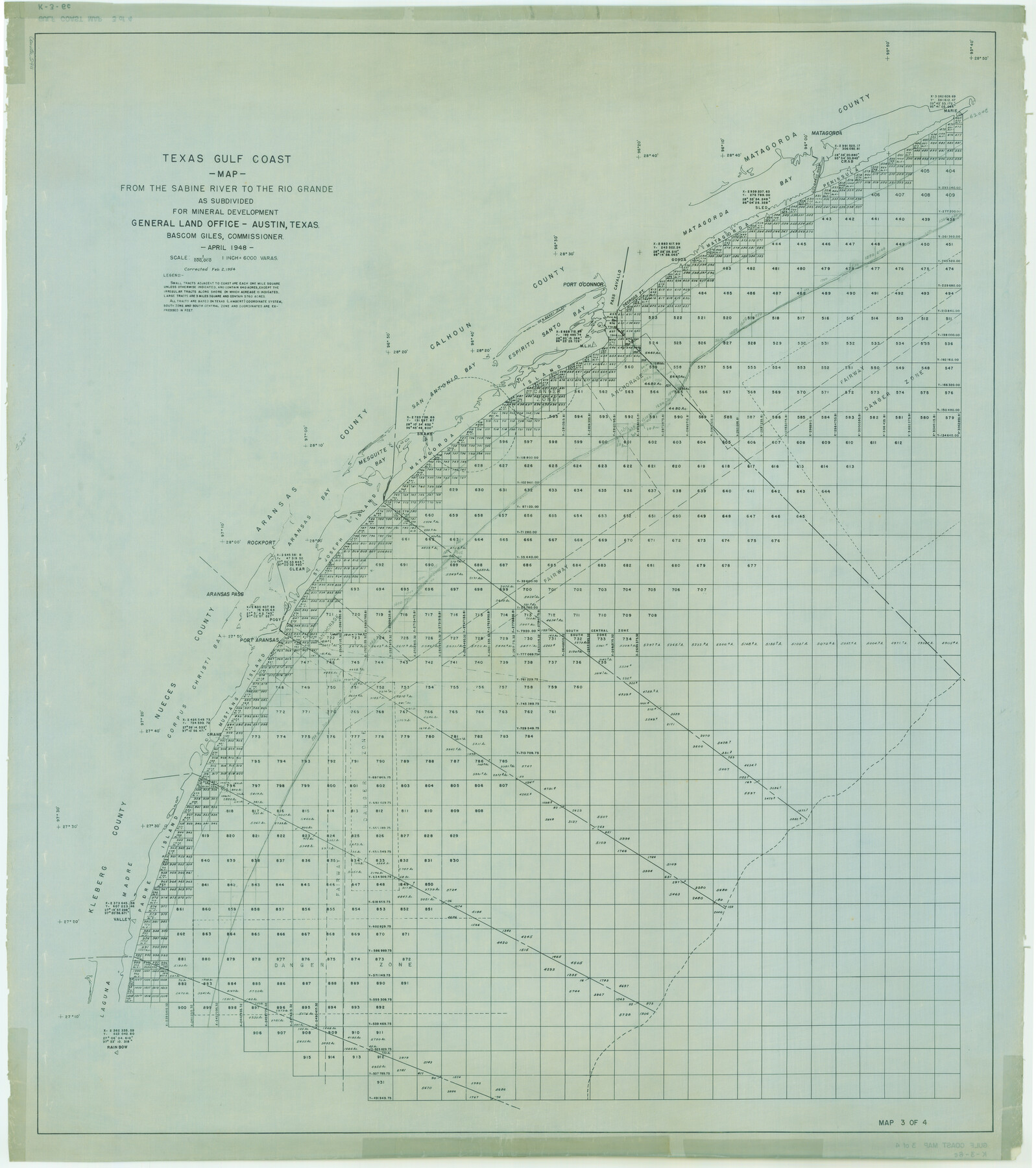
Texas Gulf Coast Map from the Sabine River to the Rio Grande as subdivided for mineral development
K-3-6
-
Map/Doc
2911
-
Collection
General Map Collection
-
Object Dates
1948 (Creation Date)
-
People and Organizations
General Land Office (Publisher)
-
Subjects
Energy Offshore Submerged Area
-
Height x Width
45.0 x 39.9 inches
114.3 x 101.3 cm
-
Comments
Obsolete as of April 1948.
Part of: General Map Collection
[Sketch for Mineral Application 20124, North Fork of Red River]
![2828, [Sketch for Mineral Application 20124, North Fork of Red River], General Map Collection](https://historictexasmaps.com/wmedia_w700/maps/2828.tif.jpg)
Print $20.00
- Digital $50.00
[Sketch for Mineral Application 20124, North Fork of Red River]
1943
Size 18.8 x 25.8 inches
Map/Doc 2828

Crockett County Sketch File 88

Print $3.00
- Digital $50.00
Crockett County Sketch File 88
1958
Size 19.3 x 15.8 inches
Map/Doc 11237
Orange County Working Sketch 40

Print $20.00
- Digital $50.00
Orange County Working Sketch 40
1979
Size 19.2 x 12.1 inches
Map/Doc 71372
Marion County Sketch File 9

Print $4.00
- Digital $50.00
Marion County Sketch File 9
Size 9.4 x 7.8 inches
Map/Doc 30577
Denton County Working Sketch 28

Print $20.00
- Digital $50.00
Denton County Working Sketch 28
1995
Size 36.1 x 22.9 inches
Map/Doc 68633
Navarro County

Print $40.00
- Digital $50.00
Navarro County
1924
Size 42.5 x 50.6 inches
Map/Doc 66951
Robertson County Working Sketch Graphic Index

Print $20.00
- Digital $50.00
Robertson County Working Sketch Graphic Index
1945
Size 46.8 x 37.9 inches
Map/Doc 76685
Edwards County Working Sketch 118

Print $20.00
- Digital $50.00
Edwards County Working Sketch 118
1974
Size 19.5 x 30.4 inches
Map/Doc 68994
Angelina County Sketch File 21

Print $6.00
- Digital $50.00
Angelina County Sketch File 21
1883
Size 8.8 x 4.0 inches
Map/Doc 13038
Current Miscellaneous File 106

Print $36.00
- Digital $50.00
Current Miscellaneous File 106
Size 8.6 x 11.3 inches
Map/Doc 74689
Flight Mission No. DQN-1K, Frame 42, Calhoun County

Print $20.00
- Digital $50.00
Flight Mission No. DQN-1K, Frame 42, Calhoun County
1953
Size 18.5 x 18.7 inches
Map/Doc 84142
You may also like
Lampasas County Working Sketch 5

Print $20.00
- Digital $50.00
Lampasas County Working Sketch 5
1947
Size 25.6 x 31.8 inches
Map/Doc 70282
Blanco County Sketch File 9

Print $4.00
- Digital $50.00
Blanco County Sketch File 9
Size 6.9 x 13.9 inches
Map/Doc 14586
Southern Part of Laguna Madre

Print $20.00
- Digital $50.00
Southern Part of Laguna Madre
1992
Size 44.9 x 35.0 inches
Map/Doc 73549
[Area along West County Line]
![90832, [Area along West County Line], Twichell Survey Records](https://historictexasmaps.com/wmedia_w700/maps/90832-2.tif.jpg)
Print $2.00
- Digital $50.00
[Area along West County Line]
Size 6.0 x 9.6 inches
Map/Doc 90832
General Highway Map. Detail of Cities and Towns in Kinney County, Uvalde County [Uvalde and vicinity]
![79557, General Highway Map. Detail of Cities and Towns in Kinney County, Uvalde County [Uvalde and vicinity], Texas State Library and Archives](https://historictexasmaps.com/wmedia_w700/maps/79557.tif.jpg)
Print $20.00
General Highway Map. Detail of Cities and Towns in Kinney County, Uvalde County [Uvalde and vicinity]
1961
Size 18.2 x 24.6 inches
Map/Doc 79557
Flight Mission No. CRC-4R, Frame 79, Chambers County

Print $20.00
- Digital $50.00
Flight Mission No. CRC-4R, Frame 79, Chambers County
1956
Size 18.9 x 22.6 inches
Map/Doc 84883
Erath County Working Sketch 36

Print $20.00
- Digital $50.00
Erath County Working Sketch 36
1973
Size 33.5 x 30.4 inches
Map/Doc 69117
Flight Mission No. DIX-6P, Frame 121, Aransas County

Print $20.00
- Digital $50.00
Flight Mission No. DIX-6P, Frame 121, Aransas County
1956
Size 18.9 x 22.6 inches
Map/Doc 83827

Flight Mission No. CUG-2P, Frame 61, Kleberg County

Print $20.00
- Digital $50.00
Flight Mission No. CUG-2P, Frame 61, Kleberg County
1956
Size 18.5 x 22.2 inches
Map/Doc 86198
Velasco, Brazoria County, Texas

Print $40.00
Velasco, Brazoria County, Texas
1891
Size 67.2 x 50.5 inches
Map/Doc 77055
Flight Mission No. BRA-7M, Frame 182, Jefferson County

Print $20.00
- Digital $50.00
Flight Mission No. BRA-7M, Frame 182, Jefferson County
1953
Size 18.5 x 22.3 inches
Map/Doc 85550