Current Miscellaneous File 76
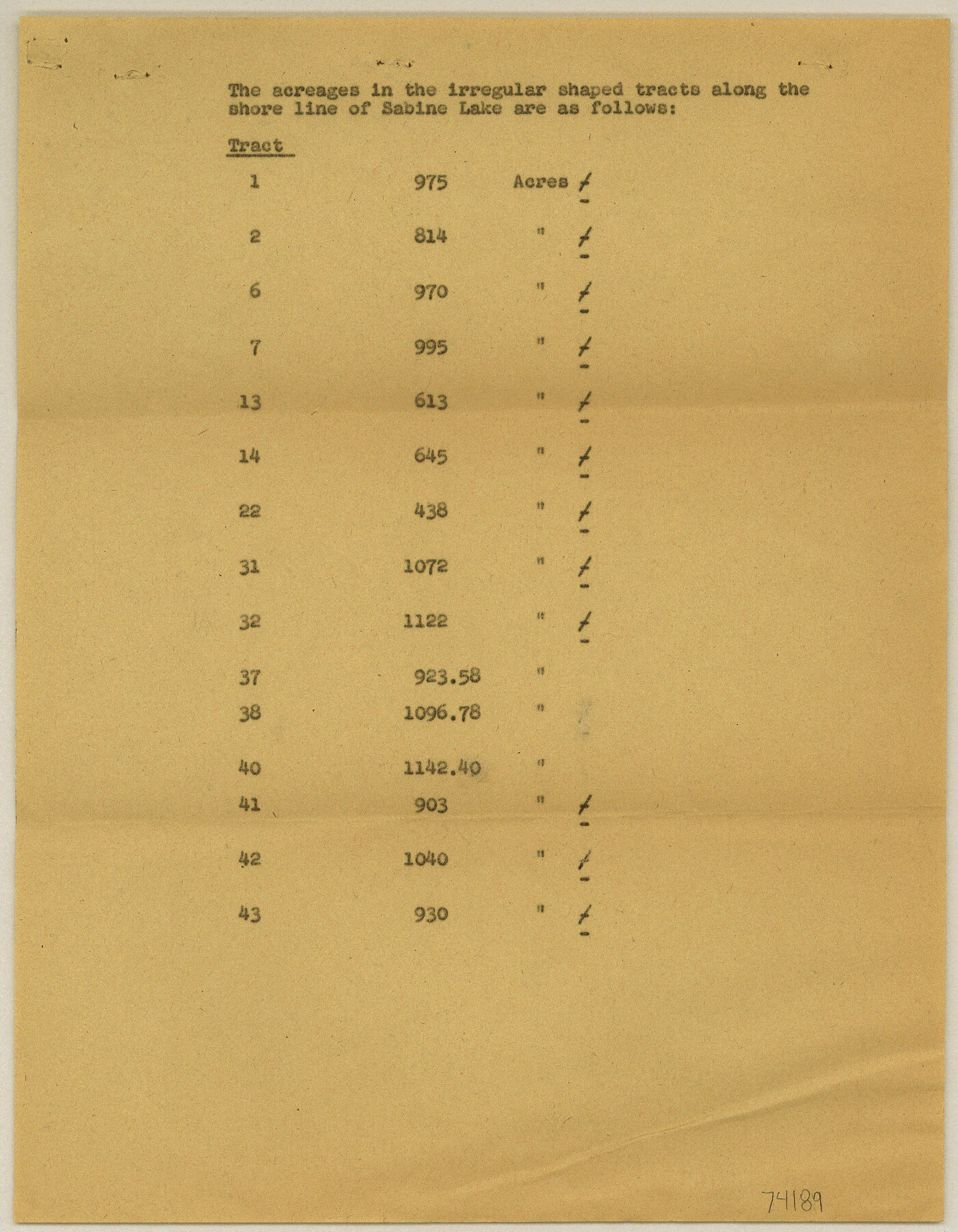
Acreages in the irregular shaped tracts along the shoreline of Sabine Lake
-
Map/Doc
74189
-
Collection
General Map Collection
-
Object Dates
1960/5/2 (Creation Date)
1960/8/5 (File Date)
-
Subjects
Energy Offshore Submerged Area
-
Height x Width
11.3 x 8.8 inches
28.7 x 22.4 cm
Part of: General Map Collection
Map of San Patricio District

Print $40.00
- Digital $50.00
Map of San Patricio District
1870
Size 43.8 x 51.4 inches
Map/Doc 1987
Cass County Sketch File 22

Print $8.00
- Digital $50.00
Cass County Sketch File 22
1849
Size 12.8 x 7.8 inches
Map/Doc 17427
Jasper County Working Sketch 9

Print $20.00
- Digital $50.00
Jasper County Working Sketch 9
1917
Size 21.0 x 14.3 inches
Map/Doc 66471
Montague County Rolled Sketch 2

Print $20.00
- Digital $50.00
Montague County Rolled Sketch 2
1940
Size 32.5 x 35.5 inches
Map/Doc 9525
Presidio County Rolled Sketch 59

Print $20.00
- Digital $50.00
Presidio County Rolled Sketch 59
Size 27.6 x 18.2 inches
Map/Doc 7352
North Sulphur River, Kinsing Sheet

Print $20.00
- Digital $50.00
North Sulphur River, Kinsing Sheet
1925
Size 30.5 x 40.8 inches
Map/Doc 65165
Jeff Davis County Sketch File 26 1/2

Print $10.00
- Digital $50.00
Jeff Davis County Sketch File 26 1/2
Size 9.0 x 10.4 inches
Map/Doc 27999
Matagorda County Aerial Photograph Index Sheet 7

Print $20.00
- Digital $50.00
Matagorda County Aerial Photograph Index Sheet 7
1953
Size 23.7 x 19.7 inches
Map/Doc 83728
Briscoe County Sketch File 4

Print $40.00
- Digital $50.00
Briscoe County Sketch File 4
Size 26.0 x 33.5 inches
Map/Doc 10993
Matagorda County Sketch File 36

Print $6.00
- Digital $50.00
Matagorda County Sketch File 36
Size 12.1 x 8.3 inches
Map/Doc 30827
1968 Texas Official State Highway Map

Digital $50.00
1968 Texas Official State Highway Map
Size 28.2 x 36.3 inches
Map/Doc 94320
Intrenched depot of the army of occupation at Point Isabel, Texas

Print $20.00
- Digital $50.00
Intrenched depot of the army of occupation at Point Isabel, Texas
1846
Size 17.0 x 25.2 inches
Map/Doc 72922
You may also like
Red River County Working Sketch 81-4

Print $20.00
- Digital $50.00
Red River County Working Sketch 81-4
1987
Size 21.8 x 16.7 inches
Map/Doc 72067
Boundary Between the United States & Mexico Agreed Upon by the Joint Commission under the Treaty of Guadalupe Hidalgo

Print $20.00
- Digital $50.00
Boundary Between the United States & Mexico Agreed Upon by the Joint Commission under the Treaty of Guadalupe Hidalgo
1853
Size 24.0 x 18.3 inches
Map/Doc 65396
Fannin County Boundary File 7

Print $42.00
- Digital $50.00
Fannin County Boundary File 7
Size 5.3 x 31.1 inches
Map/Doc 53313
Plano de la Villa y Presidio de S. Antonio de Vejar situado en la Provincia de Tejas en 29 grad. y 52 minutos de latitud bor. y 275° y 57' de long. contados desde de Meridiano d. Tenerife

Plano de la Villa y Presidio de S. Antonio de Vejar situado en la Provincia de Tejas en 29 grad. y 52 minutos de latitud bor. y 275° y 57' de long. contados desde de Meridiano d. Tenerife
1768
Size 16.8 x 21.2 inches
Map/Doc 96564
San Luis Pass to East Matagorda Bay

Print $20.00
- Digital $50.00
San Luis Pass to East Matagorda Bay
1966
Size 34.6 x 46.5 inches
Map/Doc 69965
Map of C. W. Post's Land in Hockley County, Texas

Print $20.00
- Digital $50.00
Map of C. W. Post's Land in Hockley County, Texas
Size 24.7 x 15.7 inches
Map/Doc 91095
Outer Continental Shelf Leasing Maps (Louisiana Offshore Operations)

Print $20.00
- Digital $50.00
Outer Continental Shelf Leasing Maps (Louisiana Offshore Operations)
1954
Size 15.8 x 10.0 inches
Map/Doc 76109
Flight Mission No. BQY-4M, Frame 123, Harris County

Print $20.00
- Digital $50.00
Flight Mission No. BQY-4M, Frame 123, Harris County
1953
Size 18.7 x 22.4 inches
Map/Doc 85291
McMullen County Working Sketch 57

Print $20.00
- Digital $50.00
McMullen County Working Sketch 57
1983
Size 29.5 x 18.8 inches
Map/Doc 70758
Brewster County Sketch File 45

Print $2.00
- Digital $50.00
Brewster County Sketch File 45
Size 10.7 x 8.2 inches
Map/Doc 16312
Eastland County Working Sketch 9

Print $20.00
- Digital $50.00
Eastland County Working Sketch 9
1919
Size 33.0 x 30.6 inches
Map/Doc 68790
