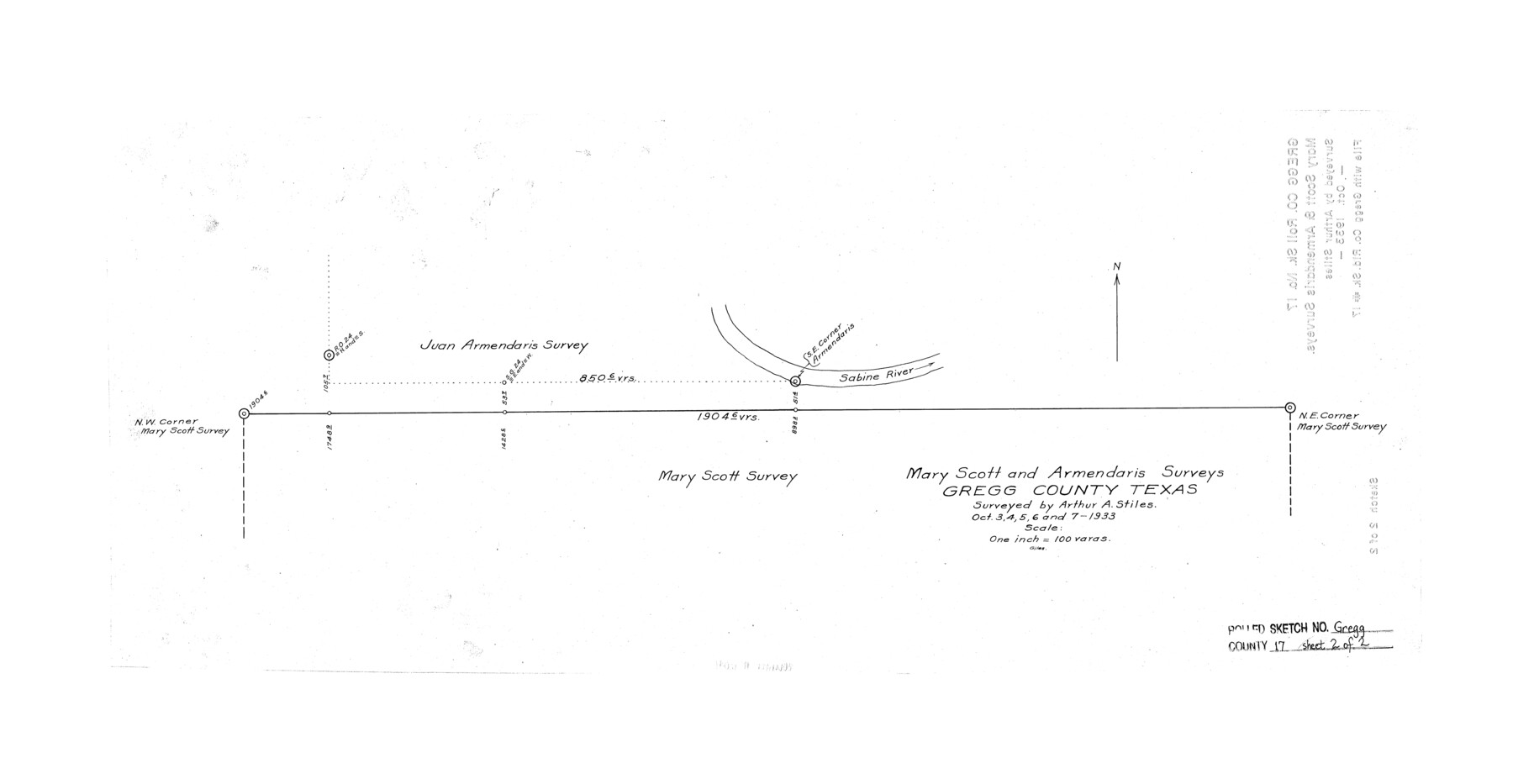
Gregg County Rolled Sketch 17
Mary Scott and Armendaris surveys - [Sheet 2 of 2]
-
Map/Doc
6041
-
Collection
General Map Collection
-
Object Dates
1933/10/7 (Creation Date)
-
People and Organizations
Arthur A. Stiles (Surveyor/Engineer)
-
Counties
Gregg
-
Subjects
Surveying Rolled Sketch
-
Height x Width
14.2 x 27.5 inches
36.1 x 69.9 cm
-
Scale
1" = 100 varas
Part of: General Map Collection
Controlled Mosaic by Jack Amman Photogrammetric Engineers, Inc - Sheet 6

Print $20.00
- Digital $50.00
Controlled Mosaic by Jack Amman Photogrammetric Engineers, Inc - Sheet 6
1954
Size 20.0 x 24.0 inches
Map/Doc 83450
Schleicher County Sketch File 27

Print $20.00
- Digital $50.00
Schleicher County Sketch File 27
Size 23.0 x 19.2 inches
Map/Doc 12305
Eastland County Working Sketch 52

Print $20.00
- Digital $50.00
Eastland County Working Sketch 52
1982
Size 25.7 x 30.0 inches
Map/Doc 68833
Kent County Boundary File 1

Print $54.00
- Digital $50.00
Kent County Boundary File 1
Size 14.2 x 8.5 inches
Map/Doc 55795
Hudspeth County Working Sketch 44

Print $20.00
- Digital $50.00
Hudspeth County Working Sketch 44
1982
Size 25.5 x 22.2 inches
Map/Doc 66329
Webb County Working Sketch 5

Print $20.00
- Digital $50.00
Webb County Working Sketch 5
1909
Size 20.1 x 15.4 inches
Map/Doc 72370
Leon River, Leon River Sheet No. 1

Print $4.00
- Digital $50.00
Leon River, Leon River Sheet No. 1
1936
Size 29.2 x 19.8 inches
Map/Doc 65067
Map of Great Britain and Ireland engraved to illustrate Mitchell's new intermediate geography

Print $20.00
- Digital $50.00
Map of Great Britain and Ireland engraved to illustrate Mitchell's new intermediate geography
1885
Size 12.2 x 9.0 inches
Map/Doc 93527
Navigation Maps of Gulf Intracoastal Waterway, Port Arthur to Brownsville, Texas

Print $4.00
- Digital $50.00
Navigation Maps of Gulf Intracoastal Waterway, Port Arthur to Brownsville, Texas
1951
Size 16.6 x 21.5 inches
Map/Doc 65452
Milam County Working Sketch 10

Print $20.00
- Digital $50.00
Milam County Working Sketch 10
1986
Size 25.5 x 34.6 inches
Map/Doc 71025
El Paso County State Real Property Sketch 4

Print $20.00
- Digital $50.00
El Paso County State Real Property Sketch 4
2012
Size 29.9 x 35.9 inches
Map/Doc 93701
Crockett County Working Sketch 46

Print $20.00
- Digital $50.00
Crockett County Working Sketch 46
1935
Size 32.9 x 27.4 inches
Map/Doc 68379
You may also like
Flight Mission No. CUG-3P, Frame 19, Kleberg County

Print $20.00
- Digital $50.00
Flight Mission No. CUG-3P, Frame 19, Kleberg County
1956
Size 18.7 x 22.3 inches
Map/Doc 86229
Flight Mission No. DAG-21K, Frame 120, Matagorda County

Print $20.00
- Digital $50.00
Flight Mission No. DAG-21K, Frame 120, Matagorda County
1952
Size 18.5 x 22.3 inches
Map/Doc 86446
Clay County Boundary File 7

Print $14.00
- Digital $50.00
Clay County Boundary File 7
Size 14.3 x 8.8 inches
Map/Doc 51377
[Survey 321, Double Lakes Area Northwest of Tahoka]
![89962, [Survey 321, Double Lakes Area Northwest of Tahoka], Twichell Survey Records](https://historictexasmaps.com/wmedia_w700/maps/89962-1.tif.jpg)
Print $20.00
- Digital $50.00
[Survey 321, Double Lakes Area Northwest of Tahoka]
Size 41.3 x 43.0 inches
Map/Doc 89962
Bosque County Sketch File 11

Print $4.00
- Digital $50.00
Bosque County Sketch File 11
1863
Size 10.2 x 8.3 inches
Map/Doc 14759
Montague County Rolled Sketch 6

Print $20.00
- Digital $50.00
Montague County Rolled Sketch 6
Size 21.8 x 30.4 inches
Map/Doc 6790
La Salle County Working Sketch 11

Print $20.00
- Digital $50.00
La Salle County Working Sketch 11
1929
Size 29.3 x 20.7 inches
Map/Doc 70312
[T. & P. Block 44, Township 1S]
![90825, [T. & P. Block 44, Township 1S], Twichell Survey Records](https://historictexasmaps.com/wmedia_w700/maps/90825-2.tif.jpg)
Print $20.00
- Digital $50.00
[T. & P. Block 44, Township 1S]
Size 17.9 x 23.3 inches
Map/Doc 90825
Hays County Boundary File 1

Print $14.00
- Digital $50.00
Hays County Boundary File 1
Size 9.5 x 5.2 inches
Map/Doc 54586
Liberty County Rolled Sketch OB

Print $40.00
- Digital $50.00
Liberty County Rolled Sketch OB
1934
Size 71.0 x 24.8 inches
Map/Doc 9563
Map of Brassos [sic] & Bosque Surveys
![146, Map of Brassos [sic] & Bosque Surveys, General Map Collection](https://historictexasmaps.com/wmedia_w700/maps/146.tif.jpg)
Print $20.00
- Digital $50.00
Map of Brassos [sic] & Bosque Surveys
1841
Size 27.7 x 18.9 inches
Map/Doc 146
Swisher County

Print $20.00
- Digital $50.00
Swisher County
1941
Size 40.9 x 35.2 inches
Map/Doc 77430