Liberty County Rolled Sketch OB
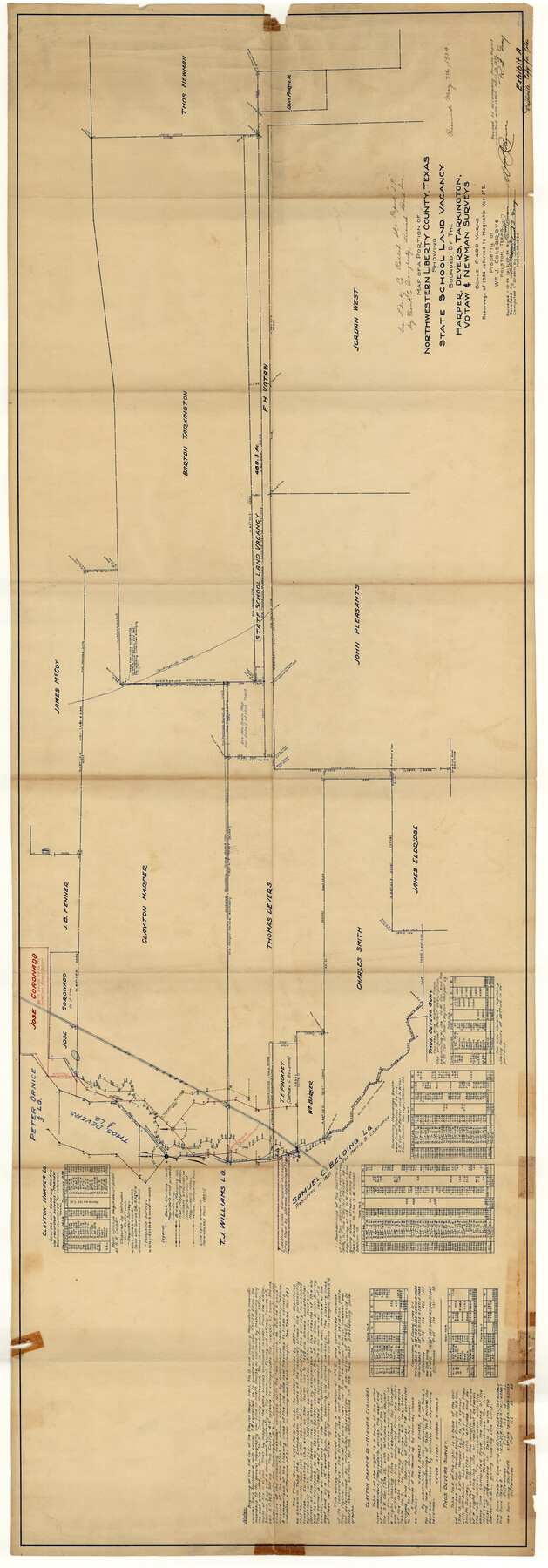
Map of a portion of northwestern Liberty County, Texas showing state School Land vacancy bounded by the Harper, Devers, Tarkington, Votaw, & Newman surveys
-
Map/Doc
9563
-
Collection
General Map Collection
-
Object Dates
1934/4/19 (Revision Date)
1934/5/7 (File Date)
1934/2/20 (Survey Date)
1934/3/19 (Creation Date)
-
People and Organizations
Richard F. Gray (Surveyor/Engineer)
Richard F. Gray (Draftsman)
-
Counties
Liberty
-
Subjects
Surveying Rolled Sketch
-
Height x Width
71.0 x 24.8 inches
180.3 x 63.0 cm
-
Medium
blueprint/diazo
-
Scale
1" = 400 varas
-
Comments
See Liberty County Rolled Sketch OB-1 (9564) for earlier copy of same sketch.
Related maps
Liberty County Rolled Sketch OB-1

Print $40.00
- Digital $50.00
Liberty County Rolled Sketch OB-1
1934
Size 70.7 x 25.1 inches
Map/Doc 9564
Part of: General Map Collection
Jefferson County Sketch File 10

Print $32.00
- Digital $50.00
Jefferson County Sketch File 10
Size 8.0 x 6.8 inches
Map/Doc 28125
Hudspeth County Rolled Sketch 20

Print $20.00
- Digital $50.00
Hudspeth County Rolled Sketch 20
Size 39.5 x 44.3 inches
Map/Doc 76028
McLennan County Boundary File 4a

Print $8.00
- Digital $50.00
McLennan County Boundary File 4a
Size 14.1 x 8.6 inches
Map/Doc 56979
Foard County Working Sketch 15

Print $40.00
- Digital $50.00
Foard County Working Sketch 15
1982
Size 43.7 x 76.0 inches
Map/Doc 69206
San Augustine County Working Sketch 6

Print $20.00
- Digital $50.00
San Augustine County Working Sketch 6
1935
Size 22.2 x 37.9 inches
Map/Doc 63693
Presidio County Rolled Sketch 71

Print $20.00
- Digital $50.00
Presidio County Rolled Sketch 71
1941
Size 31.7 x 42.9 inches
Map/Doc 7361
Township 14 South Range 14 West, South Western District, Louisiana

Print $20.00
- Digital $50.00
Township 14 South Range 14 West, South Western District, Louisiana
1838
Size 19.5 x 24.8 inches
Map/Doc 65858
Hamilton County Rolled Sketch 13

Print $20.00
- Digital $50.00
Hamilton County Rolled Sketch 13
1982
Size 34.0 x 28.0 inches
Map/Doc 6062
Travis County Boundary File 29

Print $4.00
- Digital $50.00
Travis County Boundary File 29
Size 13.2 x 8.4 inches
Map/Doc 59467

Galveston County NRC Article 33.136 Sketch 67

Print $28.00
- Digital $50.00
Galveston County NRC Article 33.136 Sketch 67
2011
Size 17.0 x 24.0 inches
Map/Doc 93391
[Letters to and from Maj. W. J. Powell regarding surveys of Texas and Pacific Ry. Lands west of the Pecos. Blks 53-55, Township 1 & 2 map within]
![2249, [Letters to and from Maj. W. J. Powell regarding surveys of Texas and Pacific Ry. Lands west of the Pecos. Blks 53-55, Township 1 & 2 map within], General Map Collection](https://historictexasmaps.com/wmedia_w700/pdf_converted_jpg/qi_pdf_thumbnail_1039.jpg)
Print $124.00
- Digital $50.00
[Letters to and from Maj. W. J. Powell regarding surveys of Texas and Pacific Ry. Lands west of the Pecos. Blks 53-55, Township 1 & 2 map within]
1934
Size 10.2 x 15.4 inches
Map/Doc 2249
You may also like
Galveston County Sketch File 32

Print $20.00
- Digital $50.00
Galveston County Sketch File 32
1916
Size 15.2 x 34.3 inches
Map/Doc 11535
Henderson County Sketch File 1

Print $8.00
- Digital $50.00
Henderson County Sketch File 1
Size 12.8 x 8.3 inches
Map/Doc 26318
Blanco County Sketch File 46

Print $4.00
- Digital $50.00
Blanco County Sketch File 46
Size 12.5 x 8.4 inches
Map/Doc 14673
Austin County Working Sketch 8

Print $20.00
- Digital $50.00
Austin County Working Sketch 8
1992
Size 28.7 x 31.6 inches
Map/Doc 67249
Liberty County Working Sketch 51

Print $20.00
- Digital $50.00
Liberty County Working Sketch 51
1955
Size 17.5 x 38.5 inches
Map/Doc 70511
Flight Mission No. DAG-23K, Frame 173, Matagorda County

Print $20.00
- Digital $50.00
Flight Mission No. DAG-23K, Frame 173, Matagorda County
1953
Size 18.5 x 22.3 inches
Map/Doc 86511
[Texas & Pacific Railway through Callahan County]
![64233, [Texas & Pacific Railway through Callahan County], General Map Collection](https://historictexasmaps.com/wmedia_w700/maps/64233.tif.jpg)
Print $20.00
- Digital $50.00
[Texas & Pacific Railway through Callahan County]
1918
Size 20.5 x 9.4 inches
Map/Doc 64233
Parker County Sketch File 42

Print $114.00
- Digital $50.00
Parker County Sketch File 42
1877
Size 14.4 x 12.0 inches
Map/Doc 33589
Nueces County Rolled Sketch 85

Print $72.00
Nueces County Rolled Sketch 85
1982
Size 18.5 x 24.9 inches
Map/Doc 6971
Kent County Sketch File 10a

Print $4.00
- Digital $50.00
Kent County Sketch File 10a
Size 5.9 x 12.0 inches
Map/Doc 28836
Bee County Rolled Sketch 1

Print $20.00
- Digital $50.00
Bee County Rolled Sketch 1
2022
Size 24.4 x 36.0 inches
Map/Doc 97029
Bailey County Sketch File 3a

Print $12.00
- Digital $50.00
Bailey County Sketch File 3a
1901
Size 8.1 x 9.0 inches
Map/Doc 13948