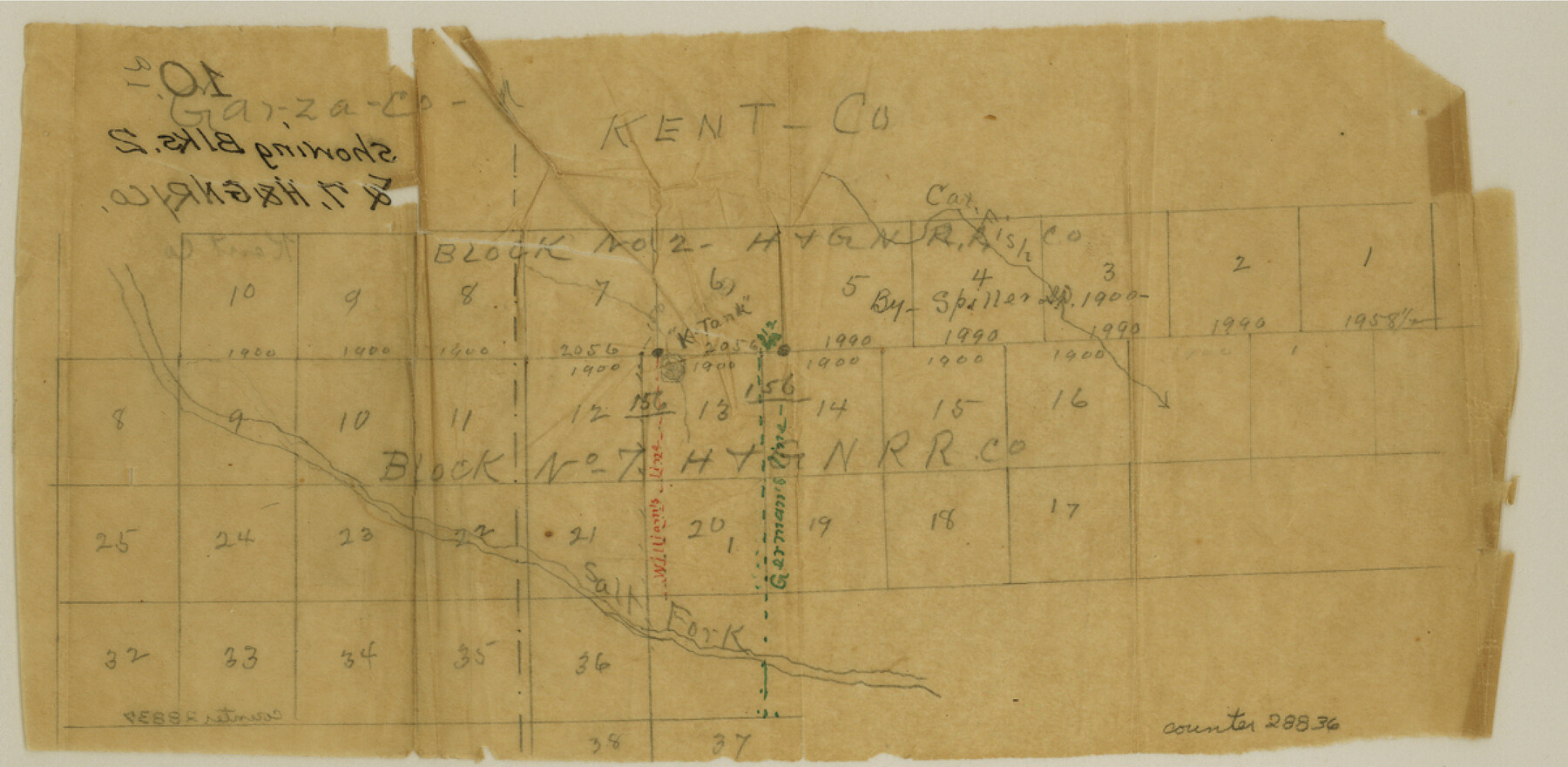
Kent County Sketch File 10a
[Sketch showing Blocks 2 and 7, H. & G. N. RR. Co. in western part of the county extending into Garza County]
-
Map/Doc
28836
-
Collection
General Map Collection
-
Counties
Kent Garza
-
Subjects
Surveying Sketch File
-
Height x Width
5.9 x 12.0 inches
15.0 x 30.5 cm
-
Medium
paper, manuscript
-
Features
Cat Fish Creek
Salt Fork
Part of: General Map Collection
No. 1 - Survey for a road from the Brazo Santiago to the Rio Grande

Print $20.00
- Digital $50.00
No. 1 - Survey for a road from the Brazo Santiago to the Rio Grande
1847
Size 18.3 x 27.1 inches
Map/Doc 72876
[Sketch for Mineral Application 11108 - Greens Bayou]
![76156, [Sketch for Mineral Application 11108 - Greens Bayou], General Map Collection](https://historictexasmaps.com/wmedia_w700/maps/76156.tif.jpg)
Print $40.00
- Digital $50.00
[Sketch for Mineral Application 11108 - Greens Bayou]
Size 58.2 x 31.4 inches
Map/Doc 76156

The south west and N.E. lines of Mary Thomas and A. Morrallis surveys

Print $2.00
- Digital $50.00
The south west and N.E. lines of Mary Thomas and A. Morrallis surveys
1847
Size 9.4 x 8.1 inches
Map/Doc 336
Flight Mission No. DQO-2K, Frame 144, Galveston County

Print $20.00
- Digital $50.00
Flight Mission No. DQO-2K, Frame 144, Galveston County
1952
Size 18.8 x 22.5 inches
Map/Doc 85041
Duval County Working Sketch 12

Print $20.00
- Digital $50.00
Duval County Working Sketch 12
1937
Size 22.1 x 27.8 inches
Map/Doc 68725
Hudspeth County Sketch File 21

Print $40.00
- Digital $50.00
Hudspeth County Sketch File 21
Size 60.1 x 38.0 inches
Map/Doc 10495
Gregg County Boundary File 6a

Print $46.00
- Digital $50.00
Gregg County Boundary File 6a
Size 12.7 x 8.2 inches
Map/Doc 54004
Jackson County Sketch File 3

Print $34.00
- Digital $50.00
Jackson County Sketch File 3
1875
Size 7.9 x 7.7 inches
Map/Doc 27621
Aransas County NRC Article 33.136 Location Key Sheet

Print $20.00
- Digital $50.00
Aransas County NRC Article 33.136 Location Key Sheet
1979
Size 27.0 x 23.0 inches
Map/Doc 87905

Crane County Working Sketch 5

Print $40.00
- Digital $50.00
Crane County Working Sketch 5
1928
Size 34.5 x 49.0 inches
Map/Doc 68282
You may also like
Controlled Mosaic by Jack Amman Photogrammetric Engineers, Inc - Sheet 31

Print $20.00
- Digital $50.00
Controlled Mosaic by Jack Amman Photogrammetric Engineers, Inc - Sheet 31
1954
Size 20.0 x 24.0 inches
Map/Doc 83484
Current Miscellaneous File 65

Print $8.00
- Digital $50.00
Current Miscellaneous File 65
Size 11.2 x 8.6 inches
Map/Doc 74109
Hardin County Sketch File 17

Print $6.00
- Digital $50.00
Hardin County Sketch File 17
1854
Size 15.9 x 9.9 inches
Map/Doc 25130
General Highway Map, Coryell County, Texas

Print $20.00
General Highway Map, Coryell County, Texas
1940
Size 18.4 x 25.4 inches
Map/Doc 79059
Nacogdoches County

Print $20.00
- Digital $50.00
Nacogdoches County
1950
Size 45.4 x 41.6 inches
Map/Doc 77381
Hutchinson County Sketch File 10

Print $40.00
- Digital $50.00
Hutchinson County Sketch File 10
Size 55.8 x 9.2 inches
Map/Doc 10500
Shelby County Rolled Sketch 8

Print $20.00
- Digital $50.00
Shelby County Rolled Sketch 8
Size 40.4 x 45.5 inches
Map/Doc 9923
Jasper County Sketch File 1a

Print $8.00
- Digital $50.00
Jasper County Sketch File 1a
1859
Size 12.1 x 7.7 inches
Map/Doc 27765
Jefferson County Rolled Sketch 61G

Print $20.00
- Digital $50.00
Jefferson County Rolled Sketch 61G
1928
Size 27.2 x 40.3 inches
Map/Doc 6416
Travis County Sketch File 19-28

Print $12.00
- Digital $50.00
Travis County Sketch File 19-28
1873
Size 8.6 x 7.7 inches
Map/Doc 38317
Galveston County NRC Article 33.136 Sketch 7

Print $20.00
- Digital $50.00
Galveston County NRC Article 33.136 Sketch 7
2001
Size 23.7 x 37.2 inches
Map/Doc 61589
Amistad International Reservoir on Rio Grande 76

Print $20.00
- Digital $50.00
Amistad International Reservoir on Rio Grande 76
1949
Size 28.5 x 40.2 inches
Map/Doc 75504