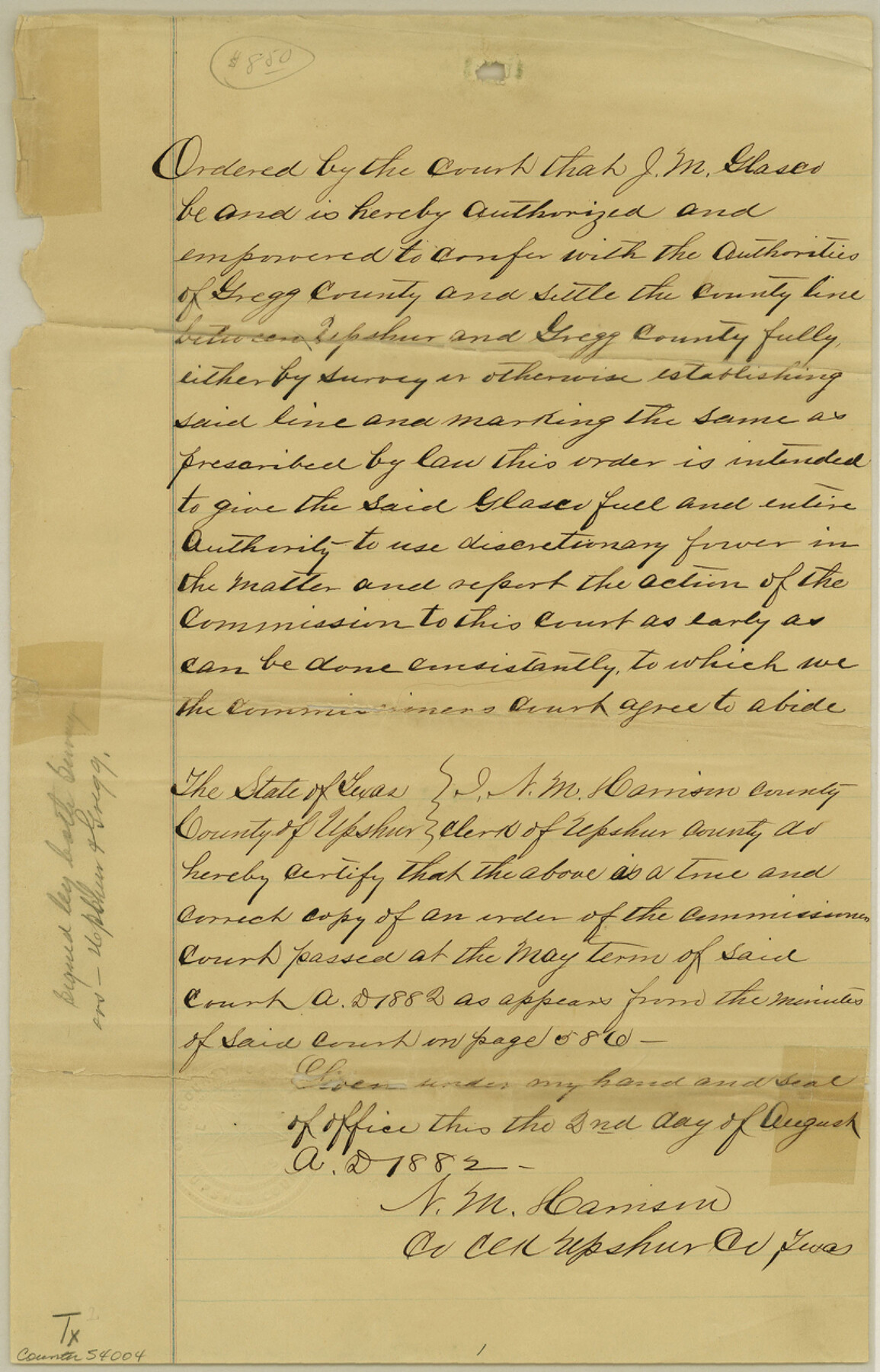
Gregg County Boundary File 6a
A plat of the lne between Upshur and Gregg counties as run by A. S. Taylor and J. M. Glasco
-
Map/Doc
54004
-
Collection
General Map Collection
-
Counties
Gregg
-
Subjects
County Boundaries
-
Height x Width
12.7 x 8.2 inches
32.3 x 20.8 cm
Part of: General Map Collection
Henderson County Boundary File 2b

Print $14.00
- Digital $50.00
Henderson County Boundary File 2b
Size 14.1 x 8.7 inches
Map/Doc 54662
Val Verde County Sketch File 47

Print $20.00
- Digital $50.00
Val Verde County Sketch File 47
1951
Size 25.1 x 18.7 inches
Map/Doc 12588
Flight Mission No. DQN-1K, Frame 130, Calhoun County

Print $20.00
- Digital $50.00
Flight Mission No. DQN-1K, Frame 130, Calhoun County
1953
Size 18.5 x 22.1 inches
Map/Doc 84193
Flight Mission No. BRE-2P, Frame 66, Nueces County

Print $20.00
- Digital $50.00
Flight Mission No. BRE-2P, Frame 66, Nueces County
1956
Size 18.6 x 22.5 inches
Map/Doc 86761
Duval County Working Sketch 5

Print $40.00
- Digital $50.00
Duval County Working Sketch 5
1933
Size 43.2 x 54.2 inches
Map/Doc 68718
Hemphill County Rolled Sketch 19

Print $20.00
- Digital $50.00
Hemphill County Rolled Sketch 19
Size 31.2 x 32.2 inches
Map/Doc 9158
Newton County Working Sketch 41

Print $20.00
- Digital $50.00
Newton County Working Sketch 41
1979
Size 17.8 x 26.2 inches
Map/Doc 71287
Gaines County Sketch File 9

Print $20.00
- Digital $50.00
Gaines County Sketch File 9
Size 34.1 x 17.1 inches
Map/Doc 11524
[Galveston, Harrisburg & San Antonio through El Paso County]
![64001, [Galveston, Harrisburg & San Antonio through El Paso County], General Map Collection](https://historictexasmaps.com/wmedia_w700/maps/64001.tif.jpg)
Print $20.00
- Digital $50.00
[Galveston, Harrisburg & San Antonio through El Paso County]
1907
Size 13.6 x 33.7 inches
Map/Doc 64001
[Beaumont, Sour Lake and Western Ry. Right of Way and Alignment - Frisco]
![64106, [Beaumont, Sour Lake and Western Ry. Right of Way and Alignment - Frisco], General Map Collection](https://historictexasmaps.com/wmedia_w700/maps/64106.tif.jpg)
Print $20.00
- Digital $50.00
[Beaumont, Sour Lake and Western Ry. Right of Way and Alignment - Frisco]
1910
Size 19.9 x 45.9 inches
Map/Doc 64106
Hale County Working Sketch 6

Print $40.00
- Digital $50.00
Hale County Working Sketch 6
1963
Size 68.9 x 38.8 inches
Map/Doc 63326
Red River County Sketch File 15

Print $4.00
- Digital $50.00
Red River County Sketch File 15
1863
Size 12.1 x 7.2 inches
Map/Doc 35137
You may also like
Hudspeth County Working Sketch 48

Print $20.00
- Digital $50.00
Hudspeth County Working Sketch 48
1984
Size 36.6 x 46.3 inches
Map/Doc 66333
[Map of Texas and Pacific Blocks from Brazos River westward through Palo Pinto, Stephens, Shackelford, Jones, Callahan, Taylor, Fisher, Nolan and Mitchell Counties]
![93457, [Map of Texas and Pacific Blocks from Brazos River westward through Palo Pinto, Stephens, Shackelford, Jones, Callahan, Taylor, Fisher, Nolan and Mitchell Counties], General Map Collection](https://historictexasmaps.com/wmedia_w700/maps/93457-1.tif.jpg)
Print $20.00
- Digital $50.00
[Map of Texas and Pacific Blocks from Brazos River westward through Palo Pinto, Stephens, Shackelford, Jones, Callahan, Taylor, Fisher, Nolan and Mitchell Counties]
Size 35.0 x 19.3 inches
Map/Doc 93457
Rockwall County

Print $20.00
- Digital $50.00
Rockwall County
1941
Size 28.7 x 23.0 inches
Map/Doc 73277
Crosby County Sketch File 19

Print $6.00
- Digital $50.00
Crosby County Sketch File 19
1910
Size 8.2 x 8.1 inches
Map/Doc 20084
Pecos County Boundary File 69

Print $22.00
- Digital $50.00
Pecos County Boundary File 69
Size 7.8 x 3.4 inches
Map/Doc 57890
Map of the Texas & Pacific Ry. Reserve West of the Pecos River

Print $20.00
- Digital $50.00
Map of the Texas & Pacific Ry. Reserve West of the Pecos River
1879
Size 41.1 x 29.8 inches
Map/Doc 65332
[Cotton Belt, St. Louis Southwestern Railway of Texas, Alignment through Smith County]
![64378, [Cotton Belt, St. Louis Southwestern Railway of Texas, Alignment through Smith County], General Map Collection](https://historictexasmaps.com/wmedia_w700/maps/64378.tif.jpg)
Print $20.00
- Digital $50.00
[Cotton Belt, St. Louis Southwestern Railway of Texas, Alignment through Smith County]
1903
Size 22.3 x 30.1 inches
Map/Doc 64378
Hartley County Working Sketch 3

Print $20.00
- Digital $50.00
Hartley County Working Sketch 3
1928
Size 24.6 x 24.0 inches
Map/Doc 66053
[University Lands Blocks 16, 18, 19 and 20]
![91593, [University Lands Blocks 16, 18, 19 and 20], Twichell Survey Records](https://historictexasmaps.com/wmedia_w700/maps/91593-1.tif.jpg)
Print $3.00
- Digital $50.00
[University Lands Blocks 16, 18, 19 and 20]
Size 8.8 x 16.8 inches
Map/Doc 91593
Webb County Sketch File 12-1

Print $16.00
- Digital $50.00
Webb County Sketch File 12-1
1886
Size 13.0 x 8.3 inches
Map/Doc 39793
Little River, Faubion Bridge Sheet

Print $4.00
- Digital $50.00
Little River, Faubion Bridge Sheet
1914
Size 19.0 x 27.8 inches
Map/Doc 65060
Flight Mission No. CLL-1N, Frame 39, Willacy County

Print $20.00
- Digital $50.00
Flight Mission No. CLL-1N, Frame 39, Willacy County
1954
Size 18.4 x 22.0 inches
Map/Doc 87020