Current Miscellaneous File 65
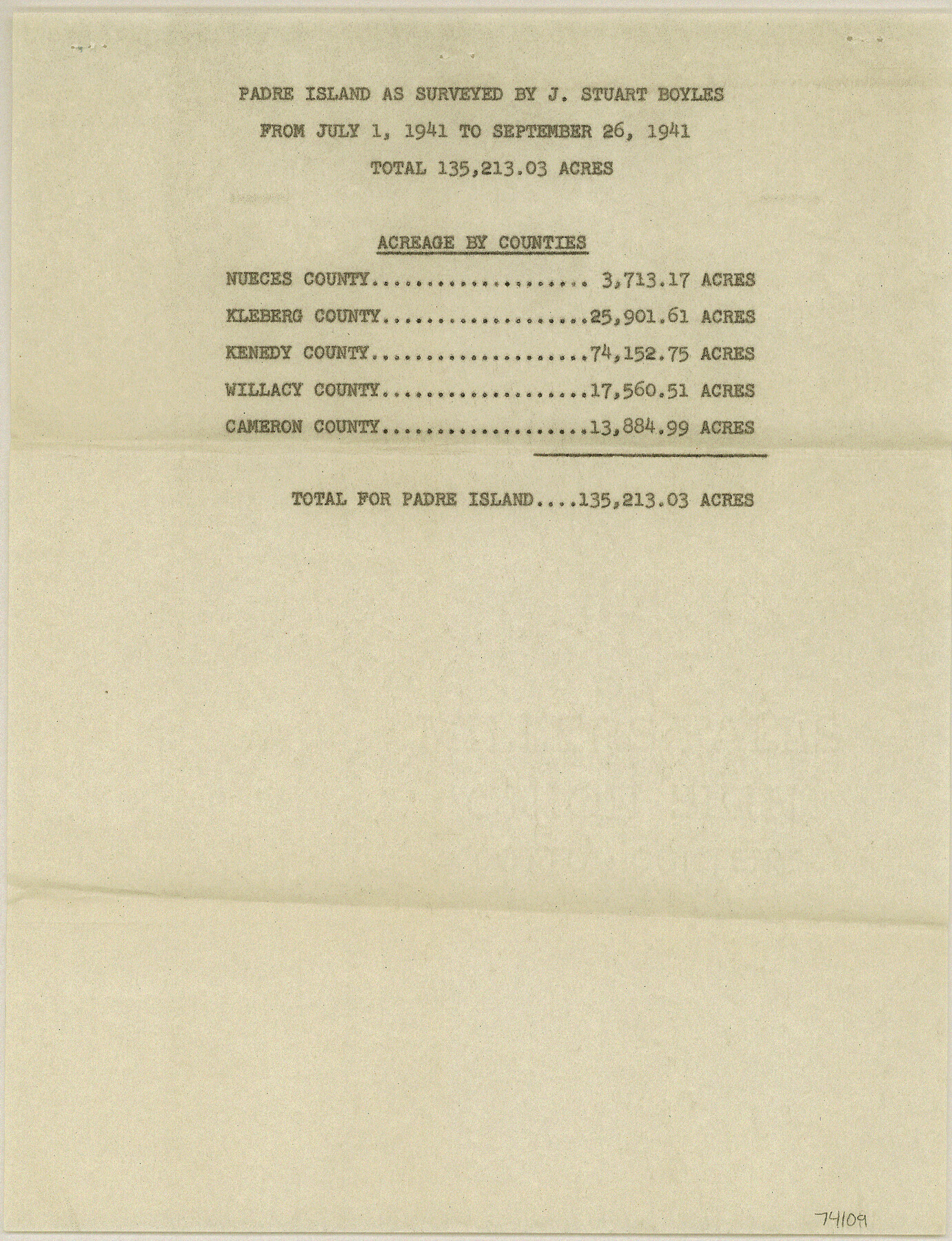
Padre Island as surveyed by J. S. Boyles July 1, 1941 to September 26, 1941. Acreage in counties
-
Map/Doc
74109
-
Collection
General Map Collection
-
Object Dates
1957/6/17 (File Date)
-
Height x Width
11.2 x 8.6 inches
28.5 x 21.8 cm
Part of: General Map Collection
Tom Green County Rolled Sketch 25

Print $20.00
- Digital $50.00
Tom Green County Rolled Sketch 25
1882
Size 14.0 x 18.5 inches
Map/Doc 8007
Trinity River, Terrell Sheet/Kings Creek

Print $20.00
- Digital $50.00
Trinity River, Terrell Sheet/Kings Creek
1930
Size 42.3 x 19.7 inches
Map/Doc 65229

Hale County Rolled Sketch 6

Print $20.00
- Digital $50.00
Hale County Rolled Sketch 6
1903
Size 35.0 x 28.9 inches
Map/Doc 6045
[Sketch for Mineral Applications 26885-6 - Reagan and Crockett Cos., W. H. Bland]
![2854, [Sketch for Mineral Applications 26885-6 - Reagan and Crockett Cos., W. H. Bland], General Map Collection](https://historictexasmaps.com/wmedia_w700/maps/2854.tif.jpg)
Print $20.00
- Digital $50.00
[Sketch for Mineral Applications 26885-6 - Reagan and Crockett Cos., W. H. Bland]
1932
Size 41.5 x 36.6 inches
Map/Doc 2854
Shackelford County Boundary File 7b

Print $90.00
- Digital $50.00
Shackelford County Boundary File 7b
Size 7.9 x 10.4 inches
Map/Doc 58692
Flight Mission No. CLL-3N, Frame 8, Willacy County

Print $20.00
- Digital $50.00
Flight Mission No. CLL-3N, Frame 8, Willacy County
1954
Size 18.5 x 22.2 inches
Map/Doc 87074
Hockley County Working Sketch 3

Print $20.00
- Digital $50.00
Hockley County Working Sketch 3
1962
Size 35.4 x 22.0 inches
Map/Doc 66193
San Jacinto County Sketch File 13a

Print $6.00
San Jacinto County Sketch File 13a
Size 8.2 x 13.0 inches
Map/Doc 35725
Cameron County Aerial Photograph Index Sheet 8

Print $20.00
- Digital $50.00
Cameron County Aerial Photograph Index Sheet 8
1955
Size 20.4 x 16.1 inches
Map/Doc 83680
Flight Mission No. DIX-10P, Frame 76, Aransas County

Print $20.00
- Digital $50.00
Flight Mission No. DIX-10P, Frame 76, Aransas County
1956
Size 18.8 x 22.4 inches
Map/Doc 83937
[Sketch for Mineral Application 21493 - Clay County]
![65625, [Sketch for Mineral Application 21493 - Clay County], General Map Collection](https://historictexasmaps.com/wmedia_w700/maps/65625-1.tif.jpg)
Print $40.00
- Digital $50.00
[Sketch for Mineral Application 21493 - Clay County]
Size 62.4 x 34.8 inches
Map/Doc 65625
You may also like
Map of Oakhurst

Print $20.00
- Digital $50.00
Map of Oakhurst
1899
Size 23.0 x 32.9 inches
Map/Doc 7556
Jack County Working Sketch 6

Print $20.00
- Digital $50.00
Jack County Working Sketch 6
1952
Size 29.1 x 24.3 inches
Map/Doc 66432

State Land for Sale on Mustang Island

Print $20.00
- Digital $50.00
State Land for Sale on Mustang Island
1910
Size 20.0 x 29.5 inches
Map/Doc 91493
Burnet County Rolled Sketch 5

Print $40.00
- Digital $50.00
Burnet County Rolled Sketch 5
1971
Size 36.5 x 49.6 inches
Map/Doc 8542
Jefferson County Rolled Sketch 61A

Print $20.00
- Digital $50.00
Jefferson County Rolled Sketch 61A
1928
Size 27.2 x 40.4 inches
Map/Doc 6410
Flight Mission No. CGI-3N, Frame 178, Cameron County

Print $20.00
- Digital $50.00
Flight Mission No. CGI-3N, Frame 178, Cameron County
1954
Size 18.5 x 22.2 inches
Map/Doc 84642
The Wonderful Lower Rio Grande Valley

Print $20.00
- Digital $50.00
The Wonderful Lower Rio Grande Valley
1909
Size 21.6 x 22.9 inches
Map/Doc 95798
Map of the British Isles to illustrate Olney's school geography (Inset: Shetland Isles)

Print $20.00
- Digital $50.00
Map of the British Isles to illustrate Olney's school geography (Inset: Shetland Isles)
1844
Size 12.1 x 9.5 inches
Map/Doc 93547
[Cotton Belt, St. Louis Southwestern Railway of Texas, Alignment through Smith County]
![64387, [Cotton Belt, St. Louis Southwestern Railway of Texas, Alignment through Smith County], General Map Collection](https://historictexasmaps.com/wmedia_w700/maps/64387.tif.jpg)
Print $20.00
- Digital $50.00
[Cotton Belt, St. Louis Southwestern Railway of Texas, Alignment through Smith County]
1903
Size 21.7 x 29.5 inches
Map/Doc 64387
Winkler County Working Sketch 2

Print $20.00
- Digital $50.00
Winkler County Working Sketch 2
1944
Size 36.9 x 29.9 inches
Map/Doc 72596
Map Showing Corrections of Capitol Leagues in Conflict in Oldham Co.

Print $40.00
- Digital $50.00
Map Showing Corrections of Capitol Leagues in Conflict in Oldham Co.
1886
Size 52.5 x 31.3 inches
Map/Doc 89800