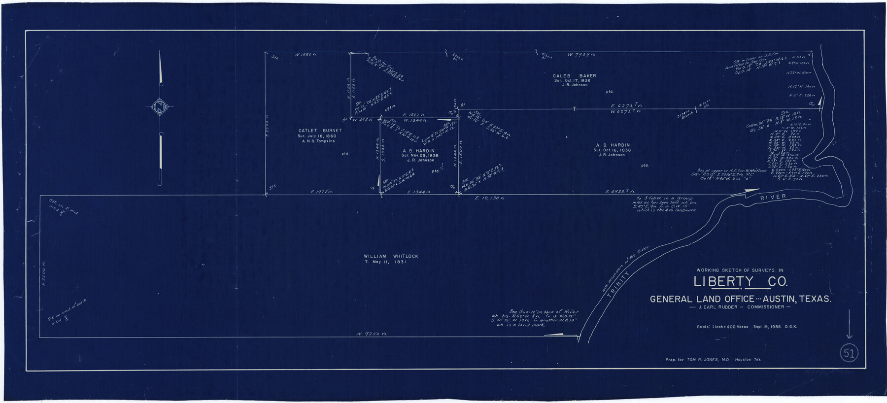
Liberty County Working Sketch 51
-
Map/Doc
70511
-
Collection
General Map Collection
-
Object Dates
9/19/1955 (Creation Date)
-
People and Organizations
Otto G. Kurio (Draftsman)
-
Counties
Liberty
-
Subjects
Surveying Working Sketch
-
Height x Width
17.5 x 38.5 inches
44.5 x 97.8 cm
-
Scale
1" = 400 varas
Part of: General Map Collection
Flight Mission No. CGI-3N, Frame 71, Cameron County

Print $20.00
- Digital $50.00
Flight Mission No. CGI-3N, Frame 71, Cameron County
1954
Size 18.4 x 22.3 inches
Map/Doc 84565
Nueces County Sketch File 8

Print $22.00
- Digital $50.00
Nueces County Sketch File 8
1849
Size 8.2 x 12.4 inches
Map/Doc 32512
Hudspeth County Sketch File 42

Print $12.00
- Digital $50.00
Hudspeth County Sketch File 42
1982
Size 14.2 x 8.7 inches
Map/Doc 27016
Coke County Sketch File 25

Print $34.00
- Digital $50.00
Coke County Sketch File 25
1930
Size 14.2 x 8.9 inches
Map/Doc 18618
Kenedy County Rolled Sketch 14

Print $21.00
- Digital $50.00
Kenedy County Rolled Sketch 14
1951
Size 10.2 x 15.3 inches
Map/Doc 46433
Dimmit County Sketch File 39

Print $8.00
- Digital $50.00
Dimmit County Sketch File 39
1901
Size 14.6 x 9.0 inches
Map/Doc 21165
Rusk County Sketch File 10

Print $4.00
Rusk County Sketch File 10
1849
Size 8.1 x 7.3 inches
Map/Doc 35507
Right of Way and Track Map Houston & Texas Central R.R. operated by the T. & N.O. R.R. Co., Austin Branch

Print $40.00
- Digital $50.00
Right of Way and Track Map Houston & Texas Central R.R. operated by the T. & N.O. R.R. Co., Austin Branch
1918
Size 25.5 x 57.7 inches
Map/Doc 64553
[Sketch for Mineral Application 27669 - Trinity River, Frank R. Graves]
![2859, [Sketch for Mineral Application 27669 - Trinity River, Frank R. Graves], General Map Collection](https://historictexasmaps.com/wmedia_w700/maps/2859-1.tif.jpg)
Print $40.00
- Digital $50.00
[Sketch for Mineral Application 27669 - Trinity River, Frank R. Graves]
1934
Size 27.9 x 51.7 inches
Map/Doc 2859

Flight Mission No. CRK-3P, Frame 61, Refugio County

Print $20.00
- Digital $50.00
Flight Mission No. CRK-3P, Frame 61, Refugio County
1956
Size 18.7 x 22.5 inches
Map/Doc 86903
Flight Mission No. CRE-2R, Frame 86, Jackson County

Print $20.00
- Digital $50.00
Flight Mission No. CRE-2R, Frame 86, Jackson County
1956
Size 16.0 x 15.8 inches
Map/Doc 85358
You may also like

Brazoria County Working Sketch 36

Print $40.00
- Digital $50.00
Brazoria County Working Sketch 36
1981
Size 43.4 x 71.4 inches
Map/Doc 67521
[Sketch around Falls County School Land and surveys to South]
![91886, [Sketch around Falls County School Land and surveys to South], Twichell Survey Records](https://historictexasmaps.com/wmedia_w700/maps/91886-1.tif.jpg)
Print $20.00
- Digital $50.00
[Sketch around Falls County School Land and surveys to South]
1894
Size 13.1 x 12.1 inches
Map/Doc 91886
Acts of the Visit of the Royal Commissioners (sometimes referred to as the “Visita General”) - Revilla [Guerrero]

Acts of the Visit of the Royal Commissioners (sometimes referred to as the “Visita General”) - Revilla [Guerrero]
1767
Size 14.1 x 9.5 inches
Map/Doc 94255
Brazoria County Rolled Sketch 49

Print $20.00
- Digital $50.00
Brazoria County Rolled Sketch 49
1948
Size 23.8 x 36.2 inches
Map/Doc 5184
[Blocks A, B and C]
![89867, [Blocks A, B and C], Twichell Survey Records](https://historictexasmaps.com/wmedia_w700/maps/89867-1.tif.jpg)
Print $40.00
- Digital $50.00
[Blocks A, B and C]
Size 36.0 x 59.0 inches
Map/Doc 89867
Guadalupe County Sketch File 2

Print $4.00
- Digital $50.00
Guadalupe County Sketch File 2
1848
Size 9.4 x 8.3 inches
Map/Doc 24648
Map Shelby County

Print $20.00
- Digital $50.00
Map Shelby County
1852
Size 20.1 x 31.5 inches
Map/Doc 4029
Loving County Working Sketch 17

Print $20.00
- Digital $50.00
Loving County Working Sketch 17
1976
Size 43.5 x 38.2 inches
Map/Doc 70651
Ward County Working Sketch 34

Print $20.00
- Digital $50.00
Ward County Working Sketch 34
1968
Size 26.7 x 30.5 inches
Map/Doc 72340
Val Verde County Sketch File 2

Print $8.00
- Digital $50.00
Val Verde County Sketch File 2
1885
Size 12.8 x 8.0 inches
Map/Doc 39169
Brewster County Working Sketch 36

Print $20.00
- Digital $50.00
Brewster County Working Sketch 36
1944
Size 22.7 x 42.3 inches
Map/Doc 67570