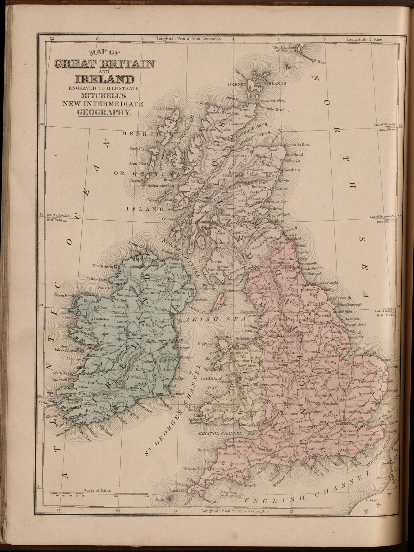
Map of Great Britain and Ireland engraved to illustrate Mitchell's new intermediate geography
-
Map/Doc
93527
-
Collection
General Map Collection
-
Object Dates
1885 (Creation Date)
2013/7/12 (File Date)
-
People and Organizations
E. H. Butler and Co. (Publisher)
Galen Greaser (Donor)
S. Augustus Mitchell (Author)
-
Subjects
Atlas Europe
-
Height x Width
12.2 x 9.0 inches
31.0 x 22.9 cm
-
Comments
Donated by Galen Greaser in 2009. Map is part of volume: "Mitchell's New Intermediate Geography (Louisiana Edition)". See 93509 for complete atlas.
Related maps
Mitchell's New Intermediate Geography (Louisiana Edition)

Print $819.00
- Digital $50.00
Mitchell's New Intermediate Geography (Louisiana Edition)
1885
Size 12.5 x 10.0 inches
Map/Doc 93509
Part of: General Map Collection
Flight Mission No. DCL-7C, Frame 44, Kenedy County

Print $20.00
- Digital $50.00
Flight Mission No. DCL-7C, Frame 44, Kenedy County
1943
Size 15.4 x 15.2 inches
Map/Doc 86032
Ward County Sketch File 12

Print $4.00
- Digital $50.00
Ward County Sketch File 12
Size 14.3 x 8.8 inches
Map/Doc 39638
Arroyo Colorado, La Feria Sheet

Print $40.00
- Digital $50.00
Arroyo Colorado, La Feria Sheet
1929
Size 24.6 x 58.5 inches
Map/Doc 65128
Boundary Between the United States & Mexico Agreed upon by the Joint Commission under the Treaty of Guadalupe Hidalgo

Print $4.00
- Digital $50.00
Boundary Between the United States & Mexico Agreed upon by the Joint Commission under the Treaty of Guadalupe Hidalgo
1853
Size 18.2 x 26.8 inches
Map/Doc 72879
Hale County Sketch File 11

Print $8.00
- Digital $50.00
Hale County Sketch File 11
1899
Size 11.1 x 8.5 inches
Map/Doc 24739
Upton County Rolled Sketch 52

Print $20.00
- Digital $50.00
Upton County Rolled Sketch 52
Size 24.5 x 29.2 inches
Map/Doc 8087
Panola County Sketch File 14

Print $4.00
- Digital $50.00
Panola County Sketch File 14
1873
Size 12.2 x 5.2 inches
Map/Doc 33472
Cass County Sketch File 3

Print $4.00
- Digital $50.00
Cass County Sketch File 3
Size 12.8 x 8.5 inches
Map/Doc 17396
Freestone County

Print $40.00
- Digital $50.00
Freestone County
1918
Size 48.9 x 42.0 inches
Map/Doc 1831
[Sketch for Mineral Application 24072, San Jacinto River]
![65596, [Sketch for Mineral Application 24072, San Jacinto River], General Map Collection](https://historictexasmaps.com/wmedia_w700/maps/65596.tif.jpg)
Print $20.00
- Digital $50.00
[Sketch for Mineral Application 24072, San Jacinto River]
1929
Size 24.5 x 18.5 inches
Map/Doc 65596
Val Verde County Rolled Sketch 69

Print $40.00
- Digital $50.00
Val Verde County Rolled Sketch 69
1942
Size 72.5 x 20.0 inches
Map/Doc 9805
Galveston County NRC Article 33.136 Sketch 48

Print $22.00
- Digital $50.00
Galveston County NRC Article 33.136 Sketch 48
2006
Size 24.4 x 36.7 inches
Map/Doc 88611
You may also like
Fractional Township No. 8 South Range No. 8 East of the Indian Meridian, Indian Territory

Print $20.00
- Digital $50.00
Fractional Township No. 8 South Range No. 8 East of the Indian Meridian, Indian Territory
1898
Size 19.2 x 24.2 inches
Map/Doc 75214
Limestone County Sketch File 2

Print $2.00
- Digital $50.00
Limestone County Sketch File 2
Size 8.0 x 6.2 inches
Map/Doc 30157
Lavaca County Rolled Sketch 6

Print $20.00
- Digital $50.00
Lavaca County Rolled Sketch 6
1986
Size 44.8 x 33.9 inches
Map/Doc 10290
Carson County Boundary File 5 and 5a

Print $50.00
- Digital $50.00
Carson County Boundary File 5 and 5a
Size 8.8 x 4.4 inches
Map/Doc 51134
Jeff Davis County Sketch File 40

Print $40.00
- Digital $50.00
Jeff Davis County Sketch File 40
1959
Size 12.8 x 18.2 inches
Map/Doc 28062
Mills County Working Sketch 27

Print $20.00
- Digital $50.00
Mills County Working Sketch 27
2000
Size 37.3 x 47.3 inches
Map/Doc 71057
[Blocks C-3, A-2, 29, GG and I]
![91612, [Blocks C-3, A-2, 29, GG and I], Twichell Survey Records](https://historictexasmaps.com/wmedia_w700/maps/91612-1.tif.jpg)
Print $20.00
- Digital $50.00
[Blocks C-3, A-2, 29, GG and I]
Size 26.0 x 18.8 inches
Map/Doc 91612
[Lgs. 180-183, 196-198, 105-112, 678-680, 699-701, 141-143]
![90155, [Lgs. 180-183, 196-198, 105-112, 678-680, 699-701, 141-143], Twichell Survey Records](https://historictexasmaps.com/wmedia_w700/maps/90155-1.tif.jpg)
Print $2.00
- Digital $50.00
[Lgs. 180-183, 196-198, 105-112, 678-680, 699-701, 141-143]
1913
Size 9.9 x 6.0 inches
Map/Doc 90155
University Land Field Notes for Blocks 1, 2, 3, 4, 5, 8, 9, and 10 in Andrews County, Block 6 in Andrews, Dawson, Gaines, and Martin Counties, and Block 7 in Andrews and Martin Counties

University Land Field Notes for Blocks 1, 2, 3, 4, 5, 8, 9, and 10 in Andrews County, Block 6 in Andrews, Dawson, Gaines, and Martin Counties, and Block 7 in Andrews and Martin Counties
Map/Doc 81710
Parker County Sketch File 36

Print $7.00
- Digital $50.00
Parker County Sketch File 36
Size 9.1 x 7.8 inches
Map/Doc 33578
Erath County Rolled Sketch 7

Print $20.00
- Digital $50.00
Erath County Rolled Sketch 7
Size 19.2 x 24.4 inches
Map/Doc 88881
PSL Field Notes for Blocks 87 through 98 in Culberson County

PSL Field Notes for Blocks 87 through 98 in Culberson County
Map/Doc 81664