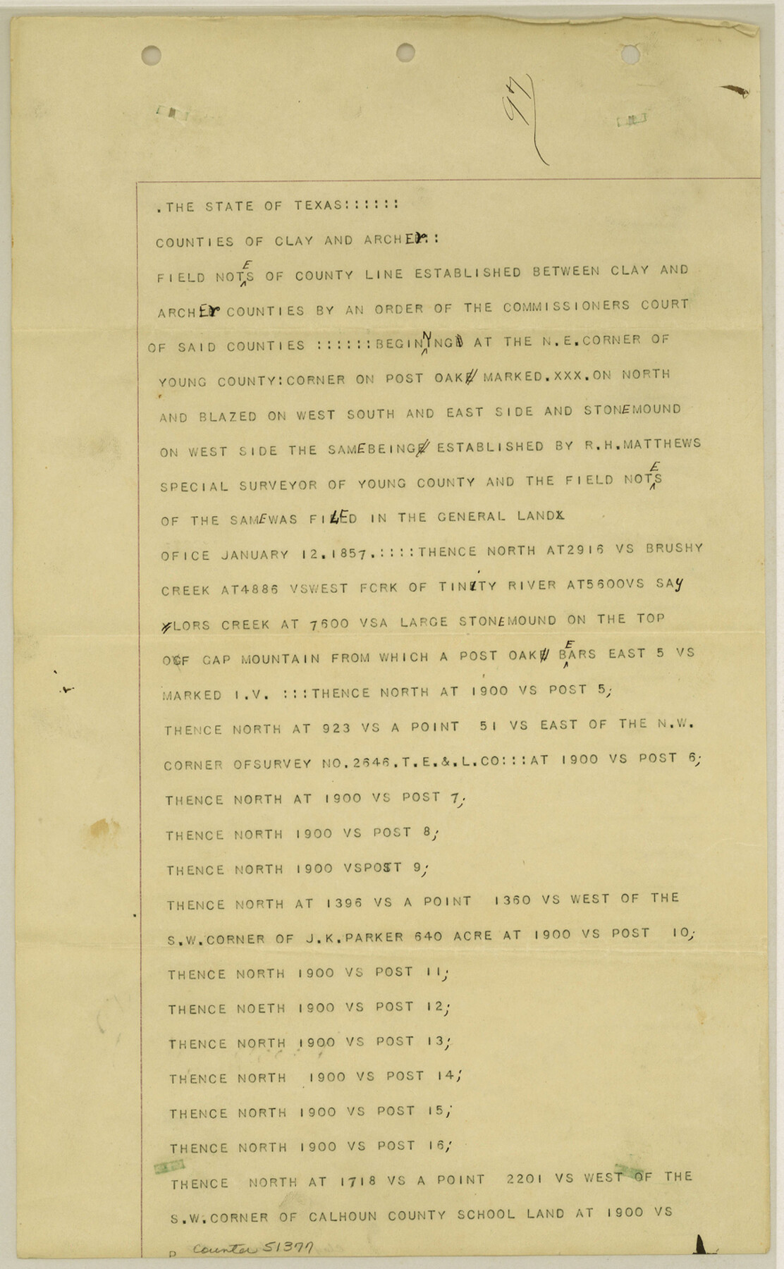
Clay County Boundary File 7
Fieldnotes of the County line established between Clay and Archer Counties
-
Map/Doc
51377
-
Collection
General Map Collection
-
Counties
Clay
-
Subjects
County Boundaries
-
Height x Width
14.3 x 8.8 inches
36.3 x 22.4 cm
Part of: General Map Collection
Map of Brown County

Print $20.00
- Digital $50.00
Map of Brown County
1858
Size 25.7 x 25.3 inches
Map/Doc 3336
Real County Working Sketch 62

Print $20.00
- Digital $50.00
Real County Working Sketch 62
1966
Size 26.4 x 23.2 inches
Map/Doc 71954
Flight Mission No. BQR-7K, Frame 24, Brazoria County

Print $20.00
- Digital $50.00
Flight Mission No. BQR-7K, Frame 24, Brazoria County
1952
Size 18.6 x 22.2 inches
Map/Doc 84022
Reagan County Sketch File 17

Print $40.00
- Digital $50.00
Reagan County Sketch File 17
Size 11.8 x 14.2 inches
Map/Doc 35006
Van Zandt County Sketch File 20a

Print $4.00
- Digital $50.00
Van Zandt County Sketch File 20a
1858
Size 12.9 x 8.0 inches
Map/Doc 39428
Presidio County Sketch File 51

Print $20.00
- Digital $50.00
Presidio County Sketch File 51
1920
Size 17.7 x 14.0 inches
Map/Doc 11716
Polk County Sketch File 14a

Print $4.00
- Digital $50.00
Polk County Sketch File 14a
1863
Size 9.0 x 14.6 inches
Map/Doc 34155
Aransas County NRC Article 33.136 Sketch 20

Print $22.00
- Digital $50.00
Aransas County NRC Article 33.136 Sketch 20
2022
Map/Doc 96876
Maverick County Working Sketch 2

Print $20.00
- Digital $50.00
Maverick County Working Sketch 2
1922
Size 46.2 x 38.5 inches
Map/Doc 70894
Pecos County Rolled Sketch 140

Print $20.00
- Digital $50.00
Pecos County Rolled Sketch 140
1954
Size 28.4 x 38.6 inches
Map/Doc 7275
Topographical Map of the Rio Grande, Sheet No. 17

Print $20.00
- Digital $50.00
Topographical Map of the Rio Grande, Sheet No. 17
1912
Map/Doc 89541
Moore County Rolled Sketch 12

Print $20.00
- Digital $50.00
Moore County Rolled Sketch 12
1919
Size 24.9 x 22.7 inches
Map/Doc 6828
You may also like
Angelina County Working Sketch 30

Print $20.00
- Digital $50.00
Angelina County Working Sketch 30
1955
Size 26.2 x 27.7 inches
Map/Doc 67112
Hardin County Sketch File A

Print $20.00
- Digital $50.00
Hardin County Sketch File A
Size 19.3 x 33.4 inches
Map/Doc 11644
Burleson County Working Sketch 14

Print $20.00
- Digital $50.00
Burleson County Working Sketch 14
1980
Size 24.6 x 18.9 inches
Map/Doc 67733
Cameron County

Print $20.00
- Digital $50.00
Cameron County
1913
Size 29.3 x 33.6 inches
Map/Doc 4902
Laguna Madre, T-9210

Print $20.00
- Digital $50.00
Laguna Madre, T-9210
Size 34.6 x 31.9 inches
Map/Doc 73601
[Connecting lines from west corner of S. K. & K. Block M6 to northwest corner section 1, J. G. & S. M. Blk. 2Z]
![90399, [Connecting lines from west corner of S. K. & K. Block M6 to northwest corner section 1, J. G. & S. M. Blk. 2Z], Twichell Survey Records](https://historictexasmaps.com/wmedia_w700/maps/90399-1.tif.jpg)
Print $20.00
- Digital $50.00
[Connecting lines from west corner of S. K. & K. Block M6 to northwest corner section 1, J. G. & S. M. Blk. 2Z]
Size 25.1 x 17.0 inches
Map/Doc 90399
Presidio County Working Sketch 80

Print $20.00
- Digital $50.00
Presidio County Working Sketch 80
1967
Size 18.8 x 30.5 inches
Map/Doc 71757
Hays County Rolled Sketch 20

Print $20.00
- Digital $50.00
Hays County Rolled Sketch 20
Size 14.1 x 36.9 inches
Map/Doc 6176
Hays County Sketch File 7

Print $4.00
- Digital $50.00
Hays County Sketch File 7
1858
Size 8.4 x 12.9 inches
Map/Doc 26208

No. 3 Chart of Channel connecting Corpus Christi Bay with Aransas Bay, Texas

Print $20.00
- Digital $50.00
No. 3 Chart of Channel connecting Corpus Christi Bay with Aransas Bay, Texas
1878
Size 18.2 x 28.0 inches
Map/Doc 72772
Pecos County Rolled Sketch 185

Print $20.00
- Digital $50.00
Pecos County Rolled Sketch 185
1985
Size 34.9 x 29.0 inches
Map/Doc 7304