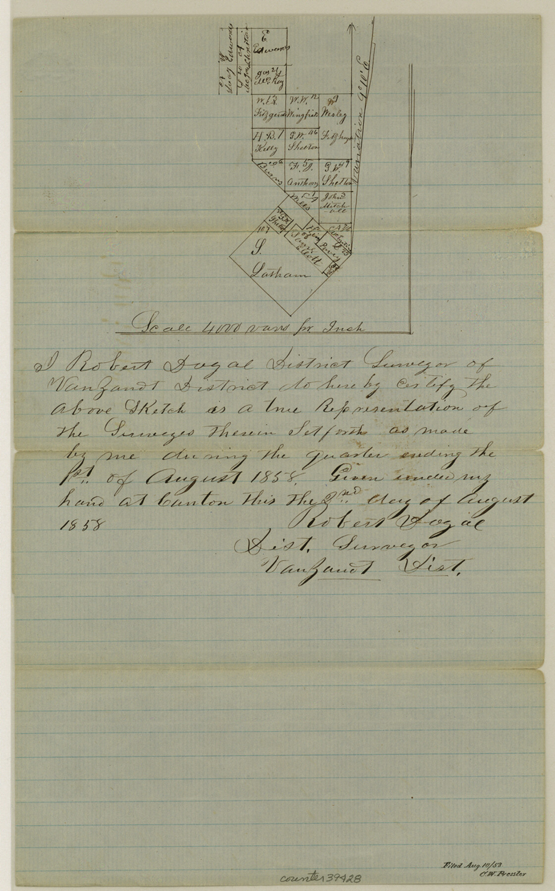
Van Zandt County Sketch File 20a
[Sketch of surveys in the northwest corner of the county]
-
Map/Doc
39428
-
Collection
General Map Collection
-
Object Dates
8/2/1858 (Creation Date)
8/10/1858 (File Date)
-
People and Organizations
Robert Doyal (Surveyor/Engineer)
-
Counties
Van Zandt
-
Subjects
Surveying Sketch File
-
Height x Width
12.9 x 8.0 inches
32.8 x 20.3 cm
-
Medium
paper, manuscript
-
Scale
1" = 4000 varas
Part of: General Map Collection

Oldham County Sketch File 5

Print $4.00
- Digital $50.00
Oldham County Sketch File 5
Size 8.5 x 11.9 inches
Map/Doc 33234
Galveston County NRC Article 33.136 Sketch 50

Print $24.00
- Digital $50.00
Galveston County NRC Article 33.136 Sketch 50
2008
Size 24.0 x 36.3 inches
Map/Doc 88750
Hardin County Rolled Sketch 22

Print $20.00
- Digital $50.00
Hardin County Rolled Sketch 22
1977
Size 32.0 x 44.4 inches
Map/Doc 9110
Flight Mission No. DQN-2K, Frame 47, Calhoun County

Print $20.00
- Digital $50.00
Flight Mission No. DQN-2K, Frame 47, Calhoun County
1953
Size 18.5 x 22.2 inches
Map/Doc 84252
Tyler County Sketch File 21

Print $4.00
- Digital $50.00
Tyler County Sketch File 21
1906
Size 10.9 x 9.1 inches
Map/Doc 38677
Crosby County Boundary File 4a

Print $30.00
- Digital $50.00
Crosby County Boundary File 4a
Size 8.8 x 32.8 inches
Map/Doc 52028
Polk County Rolled Sketch 23

Print $20.00
- Digital $50.00
Polk County Rolled Sketch 23
Size 29.1 x 23.5 inches
Map/Doc 7313
Taylor County Sketch File A1

Print $40.00
- Digital $50.00
Taylor County Sketch File A1
Size 12.8 x 14.3 inches
Map/Doc 37774
Deaf Smith County Sketch File B

Print $20.00
- Digital $50.00
Deaf Smith County Sketch File B
Size 17.0 x 14.9 inches
Map/Doc 20626
San Jacinto County Rolled Sketch 12

Print $20.00
- Digital $50.00
San Jacinto County Rolled Sketch 12
1948
Size 24.2 x 32.5 inches
Map/Doc 7561
Panola County Working Sketch 7

Print $20.00
- Digital $50.00
Panola County Working Sketch 7
1942
Map/Doc 71416
You may also like
Navarro County Sketch File 10

Print $4.00
- Digital $50.00
Navarro County Sketch File 10
1860
Size 12.6 x 8.2 inches
Map/Doc 32318
A Map of the United States including Louisiana

Print $20.00
- Digital $50.00
A Map of the United States including Louisiana
1817
Size 14.9 x 18.2 inches
Map/Doc 95964
Fort Bend County Rolled Sketch 1

Print $20.00
- Digital $50.00
Fort Bend County Rolled Sketch 1
Size 24.3 x 27.5 inches
Map/Doc 5891
Randall County Rolled Sketch 8

Print $20.00
- Digital $50.00
Randall County Rolled Sketch 8
Size 32.9 x 40.6 inches
Map/Doc 7429
Hood County Working Sketch 18

Print $40.00
- Digital $50.00
Hood County Working Sketch 18
1987
Size 38.8 x 59.0 inches
Map/Doc 66212
Map of Pecos County Texas

Print $20.00
- Digital $50.00
Map of Pecos County Texas
Size 24.5 x 19.8 inches
Map/Doc 3951
City of Washington

Print $20.00
- Digital $50.00
City of Washington
1846
Size 14.1 x 18.0 inches
Map/Doc 95358
[Location Survey of the Southern Kansas Railway, Kiowa Extension from a point in Drake's Location, in Indian Territory 100 miles from south line of Kansas, continuing up Wolf Creek and South Canadian River to Cottonwood Creek in Hutchinson County]
![88844, [Location Survey of the Southern Kansas Railway, Kiowa Extension from a point in Drake's Location, in Indian Territory 100 miles from south line of Kansas, continuing up Wolf Creek and South Canadian River to Cottonwood Creek in Hutchinson County], General Map Collection](https://historictexasmaps.com/wmedia_w700/maps/88844.tif.jpg)
Print $20.00
- Digital $50.00
[Location Survey of the Southern Kansas Railway, Kiowa Extension from a point in Drake's Location, in Indian Territory 100 miles from south line of Kansas, continuing up Wolf Creek and South Canadian River to Cottonwood Creek in Hutchinson County]
1886
Size 39.0 x 40.0 inches
Map/Doc 88844
Gaines County Rolled Sketch 10

Print $20.00
- Digital $50.00
Gaines County Rolled Sketch 10
1905
Size 16.4 x 35.8 inches
Map/Doc 5930
San Saba County Sketch File 16

Print $20.00
- Digital $50.00
San Saba County Sketch File 16
1902
Size 16.9 x 18.8 inches
Map/Doc 12294
Houston County Rolled Sketch 6

Print $40.00
- Digital $50.00
Houston County Rolled Sketch 6
1963
Size 48.0 x 34.3 inches
Map/Doc 9182
Montague County Working Sketch 6

Print $20.00
- Digital $50.00
Montague County Working Sketch 6
1923
Size 16.9 x 27.2 inches
Map/Doc 71072