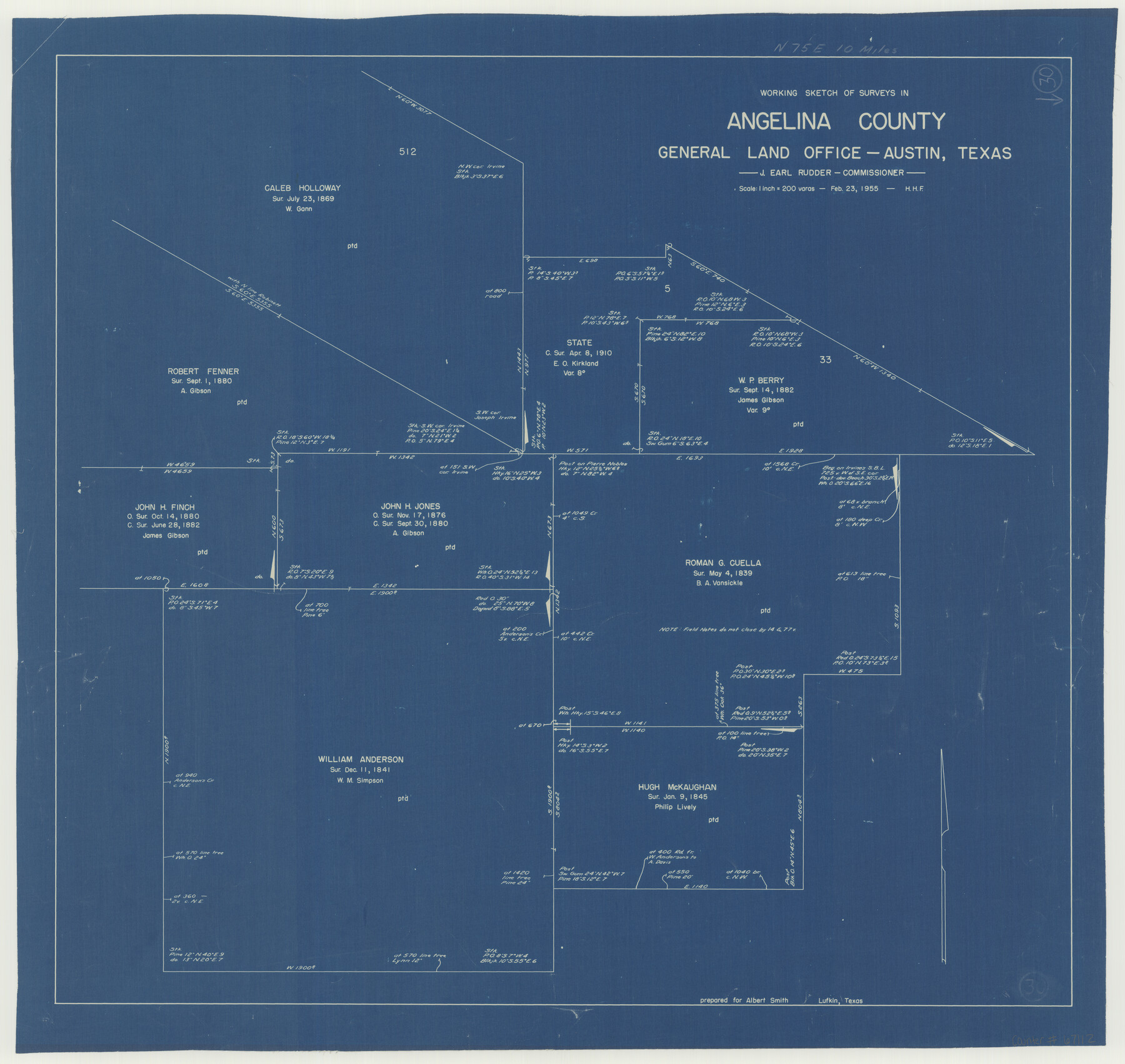
Angelina County Working Sketch 30
-
Map/Doc
67112
-
Collection
General Map Collection
-
Object Dates
2/23/1955 (Creation Date)
-
People and Organizations
J. Earl Rudder (GLO Commissioner)
Herman Forbes (Draftsman)
-
Counties
Angelina
-
Subjects
Surveying Working Sketch
-
Height x Width
26.2 x 27.7 inches
66.6 x 70.4 cm
-
Scale
1" = 200 varas
-
Comments
Surveys located about 10 miles North 75 degrees East from Lufkin, Texas.
Part of: General Map Collection
Swisher County

Print $20.00
- Digital $50.00
Swisher County
1910
Size 47.5 x 39.8 inches
Map/Doc 16888
Austin Map and Street Guide [Verso]
![94163, Austin Map and Street Guide [Verso], General Map Collection](https://historictexasmaps.com/wmedia_w700/maps/94163.tif.jpg)
Austin Map and Street Guide [Verso]
1986
Size 35.5 x 22.8 inches
Map/Doc 94163
Falls County Rolled Sketch 1

Print $73.00
- Digital $50.00
Falls County Rolled Sketch 1
1934
Size 10.6 x 15.1 inches
Map/Doc 44540
Flight Mission No. CLL-1N, Frame 83, Willacy County

Print $20.00
- Digital $50.00
Flight Mission No. CLL-1N, Frame 83, Willacy County
1954
Size 18.3 x 22.0 inches
Map/Doc 87029
Harris County Working Sketch 39

Print $20.00
- Digital $50.00
Harris County Working Sketch 39
1940
Size 21.6 x 20.1 inches
Map/Doc 65931
Oldham County Working Sketch 10

Print $20.00
- Digital $50.00
Oldham County Working Sketch 10
1983
Size 29.6 x 44.3 inches
Map/Doc 71332
Presidio County Working Sketch 145

Print $20.00
- Digital $50.00
Presidio County Working Sketch 145
1990
Size 29.5 x 42.7 inches
Map/Doc 71823
Crockett County Sketch File 93

Print $8.00
- Digital $50.00
Crockett County Sketch File 93
1887
Size 12.7 x 8.2 inches
Map/Doc 19946
Lynn County Rolled Sketch 10

Print $20.00
- Digital $50.00
Lynn County Rolled Sketch 10
Size 13.1 x 18.5 inches
Map/Doc 6646
Copy of Surveyor's Field Book, Morris Browning - In Blocks 7, 5 & 4, I&GNRRCo., Hutchinson and Carson Counties, Texas

Print $2.00
- Digital $50.00
Copy of Surveyor's Field Book, Morris Browning - In Blocks 7, 5 & 4, I&GNRRCo., Hutchinson and Carson Counties, Texas
1888
Size 7.0 x 8.8 inches
Map/Doc 62286
Presidio County Rolled Sketch 131A

Print $20.00
- Digital $50.00
Presidio County Rolled Sketch 131A
Size 47.5 x 36.6 inches
Map/Doc 10711
Flight Mission No. BQY-14M, Frame 182, Harris County

Print $20.00
- Digital $50.00
Flight Mission No. BQY-14M, Frame 182, Harris County
1953
Size 18.5 x 22.4 inches
Map/Doc 85298
You may also like
Presidio County Working Sketch 48

Print $20.00
- Digital $50.00
Presidio County Working Sketch 48
1950
Size 36.2 x 31.0 inches
Map/Doc 71725
Mexico or New Spain in which the Motions of Cortes may be traced

Print $20.00
- Digital $50.00
Mexico or New Spain in which the Motions of Cortes may be traced
1795
Size 14.5 x 16.5 inches
Map/Doc 93650
Winkler County Working Sketch 15

Print $20.00
- Digital $50.00
Winkler County Working Sketch 15
1964
Size 29.2 x 30.5 inches
Map/Doc 72609
Pecos County Working Sketch 106

Print $40.00
- Digital $50.00
Pecos County Working Sketch 106
1971
Size 64.9 x 38.1 inches
Map/Doc 71579
La Salle County Working Sketch 50

Print $40.00
- Digital $50.00
La Salle County Working Sketch 50
1985
Size 50.6 x 26.2 inches
Map/Doc 70351
Waller County Working Sketch 5

Print $20.00
- Digital $50.00
Waller County Working Sketch 5
1966
Size 23.1 x 27.1 inches
Map/Doc 72304
Hockley County Sketch File 19b

Print $28.00
- Digital $50.00
Hockley County Sketch File 19b
Size 11.3 x 8.8 inches
Map/Doc 26555
Wheeler County Working Sketch 5

Print $40.00
- Digital $50.00
Wheeler County Working Sketch 5
1972
Size 55.3 x 45.9 inches
Map/Doc 72494
Brewster County Rolled Sketch 121A

Print $40.00
- Digital $50.00
Brewster County Rolled Sketch 121A
1946
Size 37.4 x 54.5 inches
Map/Doc 8518
Montgomery County Sketch File 30

Print $20.00
- Digital $50.00
Montgomery County Sketch File 30
Size 37.5 x 41.7 inches
Map/Doc 10549
Andrews County Working Sketch 6

Print $20.00
- Digital $50.00
Andrews County Working Sketch 6
1954
Size 18.4 x 42.9 inches
Map/Doc 67052
Carte du Mexique et de la Floride des Terres Angloises et des Isles Antilles du Cours et des Environs de la Riviere Mississipi

Print $20.00
- Digital $50.00
Carte du Mexique et de la Floride des Terres Angloises et des Isles Antilles du Cours et des Environs de la Riviere Mississipi
1703
Size 21.8 x 30.0 inches
Map/Doc 94852