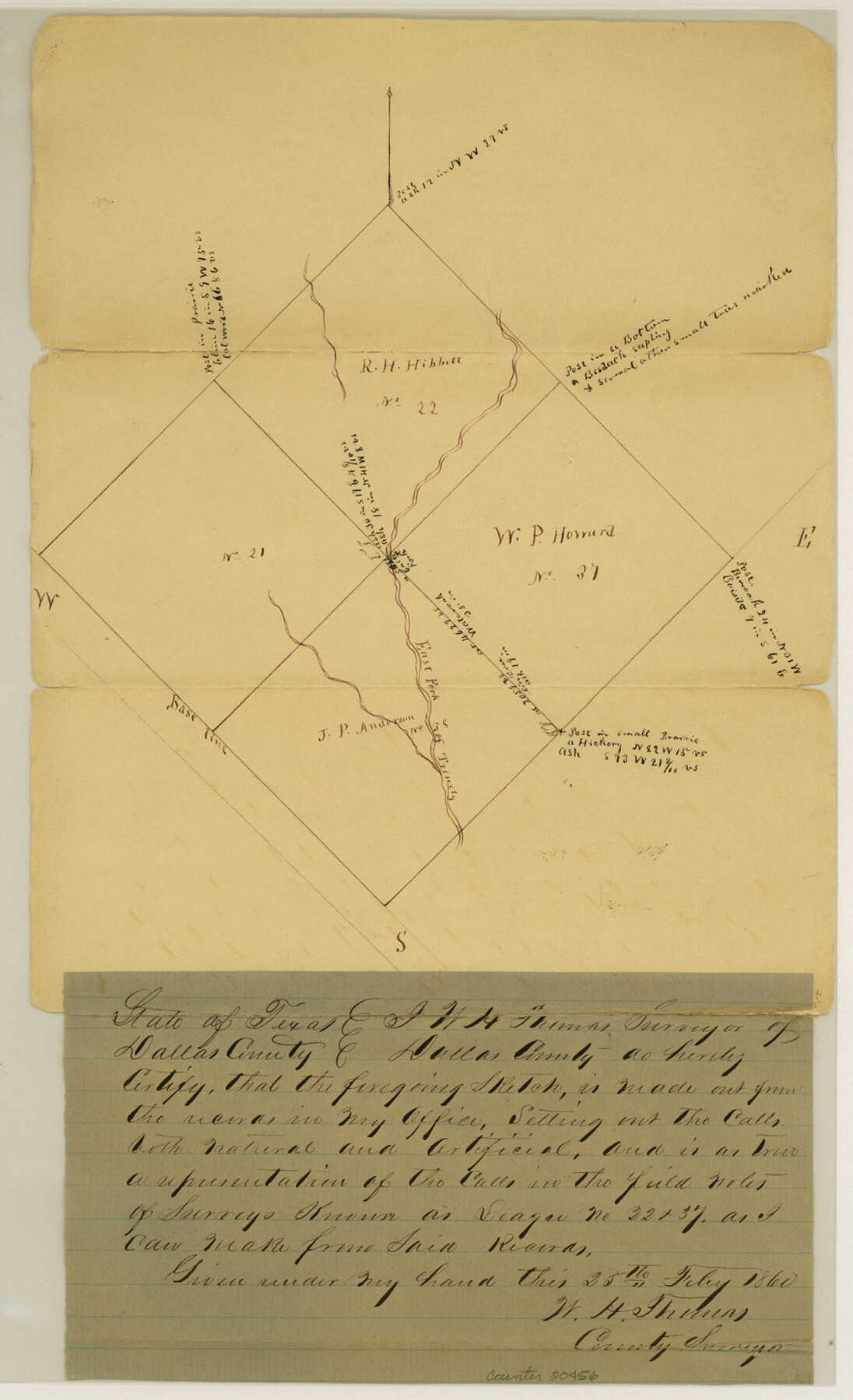
Dallas County Sketch File 23
[Sketch of surveys on East Fork of Bois d'Arc around leagues 21, 22, 37 and 38]
-
Map/Doc
20456
-
Collection
General Map Collection
-
Object Dates
1860/2/25 (Creation Date)
-
People and Organizations
W.H. Thomas (Surveyor/Engineer)
-
Counties
Dallas Kaufman
-
Subjects
Surveying Sketch File
-
Height x Width
14.5 x 8.8 inches
36.8 x 22.4 cm
-
Medium
paper, manuscript
-
Features
East Fork of Trinity River
Bois D'Arc Creek
Part of: General Map Collection

Anderson County Sketch File 24

Print $60.00
- Digital $50.00
Anderson County Sketch File 24
1942
Size 13.2 x 18.2 inches
Map/Doc 10803
Sabine and Neches Rivers

Print $20.00
- Digital $50.00
Sabine and Neches Rivers
1976
Size 19.8 x 44.9 inches
Map/Doc 69819
Bee County Working Sketch 30

Print $20.00
- Digital $50.00
Bee County Working Sketch 30
1950
Size 12.7 x 15.7 inches
Map/Doc 67281
Dawson County

Print $20.00
- Digital $50.00
Dawson County
1892
Size 27.1 x 23.3 inches
Map/Doc 66797
Trinity County Sketch File 10

Print $8.00
- Digital $50.00
Trinity County Sketch File 10
1858
Size 13.1 x 8.0 inches
Map/Doc 38527
Nouvelle Carte du Mexique du Texas et d'une partie des états limitrophes

Print $20.00
- Digital $50.00
Nouvelle Carte du Mexique du Texas et d'une partie des états limitrophes
1834
Size 39.9 x 27.4 inches
Map/Doc 94098
Roberts County Working Sketch 33

Print $20.00
- Digital $50.00
Roberts County Working Sketch 33
1978
Size 26.6 x 22.4 inches
Map/Doc 63559
Fort Bend County Working Sketch 22

Print $20.00
- Digital $50.00
Fort Bend County Working Sketch 22
1968
Size 37.4 x 37.3 inches
Map/Doc 69228
Map Showing Location of Galveston, Harrisburg & San Antonio Railway

Print $40.00
- Digital $50.00
Map Showing Location of Galveston, Harrisburg & San Antonio Railway
1881
Size 17.4 x 59.3 inches
Map/Doc 64457
Jim Hogg County Working Sketch 9

Print $20.00
- Digital $50.00
Jim Hogg County Working Sketch 9
1973
Size 14.3 x 11.2 inches
Map/Doc 66595
Tyler County Sketch File 16

Print $6.00
- Digital $50.00
Tyler County Sketch File 16
1860
Size 9.4 x 11.8 inches
Map/Doc 38661
You may also like
Atascosa County Sketch File 25

Print $4.00
- Digital $50.00
Atascosa County Sketch File 25
Size 12.7 x 8.0 inches
Map/Doc 13792
DeWitt County Boundary File 2a

Print $2.00
- Digital $50.00
DeWitt County Boundary File 2a
Size 10.7 x 8.1 inches
Map/Doc 52513
Denton County Sketch File 19

Print $10.00
- Digital $50.00
Denton County Sketch File 19
Size 10.0 x 7.3 inches
Map/Doc 20733
Burleson County Sketch File 6

Print $4.00
- Digital $50.00
Burleson County Sketch File 6
1865
Size 8.0 x 9.3 inches
Map/Doc 16651
Kenedy & Kleberg Counties, Riviera Beach

Print $20.00
- Digital $50.00
Kenedy & Kleberg Counties, Riviera Beach
1952
Size 32.6 x 28.1 inches
Map/Doc 73507
Flight Mission No. DQO-7K, Frame 108, Galveston County

Print $20.00
- Digital $50.00
Flight Mission No. DQO-7K, Frame 108, Galveston County
1952
Size 18.7 x 22.5 inches
Map/Doc 85123
Flight Mission No. BRE-2P, Frame 81, Nueces County

Print $20.00
- Digital $50.00
Flight Mission No. BRE-2P, Frame 81, Nueces County
1956
Size 18.6 x 22.5 inches
Map/Doc 86776
United States - Gulf Coast Texas - Northern part of Laguna Madre

Print $20.00
- Digital $50.00
United States - Gulf Coast Texas - Northern part of Laguna Madre
1941
Size 18.4 x 24.2 inches
Map/Doc 72936
Tyler County Boundary File 89

Print $28.00
- Digital $50.00
Tyler County Boundary File 89
Size 9.2 x 7.2 inches
Map/Doc 59495
Blanco County Working Sketch 45

Print $20.00
- Digital $50.00
Blanco County Working Sketch 45
2007
Size 23.9 x 34.0 inches
Map/Doc 88609
Reagan County Working Sketch 42

Print $20.00
- Digital $50.00
Reagan County Working Sketch 42
1973
Size 19.9 x 37.0 inches
Map/Doc 71884
Intracoastal Waterway in Texas - Corpus Christi to Point Isabel including Arroyo Colorado to Mo. Pac. R.R. Bridge Near Harlingen

Print $20.00
- Digital $50.00
Intracoastal Waterway in Texas - Corpus Christi to Point Isabel including Arroyo Colorado to Mo. Pac. R.R. Bridge Near Harlingen
1933
Size 28.1 x 40.8 inches
Map/Doc 61876