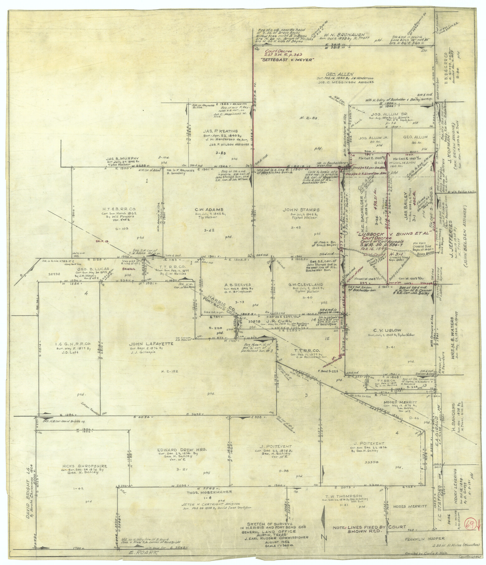
Harris County Working Sketch 69
-
Map/Doc
65961
-
Collection
General Map Collection
-
Object Dates
8/1956 (Creation Date)
-
People and Organizations
Curtis R. Hale (Draftsman)
-
Counties
Harris Fort Bend
-
Subjects
Surveying Working Sketch
-
Height x Width
32.7 x 28.2 inches
83.1 x 71.6 cm
-
Scale
1" = 360 varas
Part of: General Map Collection
Louisiana and Texas Intracoastal Waterway - High Island to Port Bolivar Dredging - Sheet 5

Print $20.00
- Digital $50.00
Louisiana and Texas Intracoastal Waterway - High Island to Port Bolivar Dredging - Sheet 5
1943
Size 31.4 x 41.8 inches
Map/Doc 61824
Lee County Working Sketch 15

Print $20.00
- Digital $50.00
Lee County Working Sketch 15
1981
Size 18.4 x 14.0 inches
Map/Doc 70394
Jeff Davis County Working Sketch Graphic Index - central part

Print $40.00
- Digital $50.00
Jeff Davis County Working Sketch Graphic Index - central part
1982
Size 55.7 x 42.6 inches
Map/Doc 76593
Map of the Lands Surveyed by the Memphis, El Paso & Pacific R.R. Company

Print $20.00
- Digital $50.00
Map of the Lands Surveyed by the Memphis, El Paso & Pacific R.R. Company
1860
Size 16.7 x 24.7 inches
Map/Doc 4845
Brazoria County Sketch File 20

Print $40.00
- Digital $50.00
Brazoria County Sketch File 20
1853
Size 22.3 x 15.0 inches
Map/Doc 10953
Morris County Rolled Sketch 2A

Print $20.00
- Digital $50.00
Morris County Rolled Sketch 2A
Size 22.6 x 17.7 inches
Map/Doc 10285
Cottle County

Print $20.00
- Digital $50.00
Cottle County
1908
Size 43.9 x 39.0 inches
Map/Doc 66788
Colorado County Sketch File 29

Print $6.00
- Digital $50.00
Colorado County Sketch File 29
1842
Size 11.2 x 9.0 inches
Map/Doc 18974
Grayson County Sketch File 6

Print $8.00
- Digital $50.00
Grayson County Sketch File 6
Size 12.9 x 8.2 inches
Map/Doc 24466
Motley County Working Sketch Graphic Index

Print $20.00
- Digital $50.00
Motley County Working Sketch Graphic Index
1966
Size 42.3 x 33.3 inches
Map/Doc 76650
Flight Mission No. BRA-8M, Frame 25, Jefferson County

Print $20.00
- Digital $50.00
Flight Mission No. BRA-8M, Frame 25, Jefferson County
1953
Size 18.4 x 22.5 inches
Map/Doc 85580
Concho County Sketch File 2

Print $4.00
- Digital $50.00
Concho County Sketch File 2
1859
Size 10.5 x 8.5 inches
Map/Doc 19122
You may also like
Laneer vs. Bivins, Potter County, Texas

Print $20.00
- Digital $50.00
Laneer vs. Bivins, Potter County, Texas
Size 21.1 x 18.8 inches
Map/Doc 93062
Brazoria County Rolled Sketch 49

Print $20.00
- Digital $50.00
Brazoria County Rolled Sketch 49
1948
Size 23.8 x 36.2 inches
Map/Doc 5184
Llano County Boundary File 2

Print $30.00
- Digital $50.00
Llano County Boundary File 2
Size 14.3 x 8.8 inches
Map/Doc 56443
Mapa de los Estados Unidos de Méjico, Segun lo organizado y definido por las varias actas del Congreso de dicha Republica: y construido por las mejores autoridades

Print $20.00
- Digital $50.00
Mapa de los Estados Unidos de Méjico, Segun lo organizado y definido por las varias actas del Congreso de dicha Republica: y construido por las mejores autoridades
1847
Size 31.3 x 42.3 inches
Map/Doc 93878
[Southwest part of County]
![90921, [Southwest part of County], Twichell Survey Records](https://historictexasmaps.com/wmedia_w700/maps/90921-1.tif.jpg)
Print $20.00
- Digital $50.00
[Southwest part of County]
Size 29.0 x 18.3 inches
Map/Doc 90921
Val Verde County Sketch File XXX

Print $30.00
- Digital $50.00
Val Verde County Sketch File XXX
1908
Size 39.2 x 24.6 inches
Map/Doc 10424
[Sketch for Mineral Application 15559 - Hutchinson County, Canadian River]
![65681, [Sketch for Mineral Application 15559 - Hutchinson County, Canadian River], General Map Collection](https://historictexasmaps.com/wmedia_w700/maps/65681-1.tif.jpg)
Print $20.00
- Digital $50.00
[Sketch for Mineral Application 15559 - Hutchinson County, Canadian River]
1926
Size 13.2 x 12.0 inches
Map/Doc 65681

Gaines County Sketch File 2M

Print $20.00
- Digital $50.00
Gaines County Sketch File 2M
1902
Size 20.8 x 29.4 inches
Map/Doc 11522
Coke County Rolled Sketch 21

Print $20.00
- Digital $50.00
Coke County Rolled Sketch 21
1954
Size 14.0 x 24.4 inches
Map/Doc 5522
Borden County Boundary File 4

Print $66.00
- Digital $50.00
Borden County Boundary File 4
1908
Size 23.7 x 125.7 inches
Map/Doc 1694
Limestone County Working Sketch 12

Print $20.00
- Digital $50.00
Limestone County Working Sketch 12
1922
Size 18.5 x 12.8 inches
Map/Doc 70562