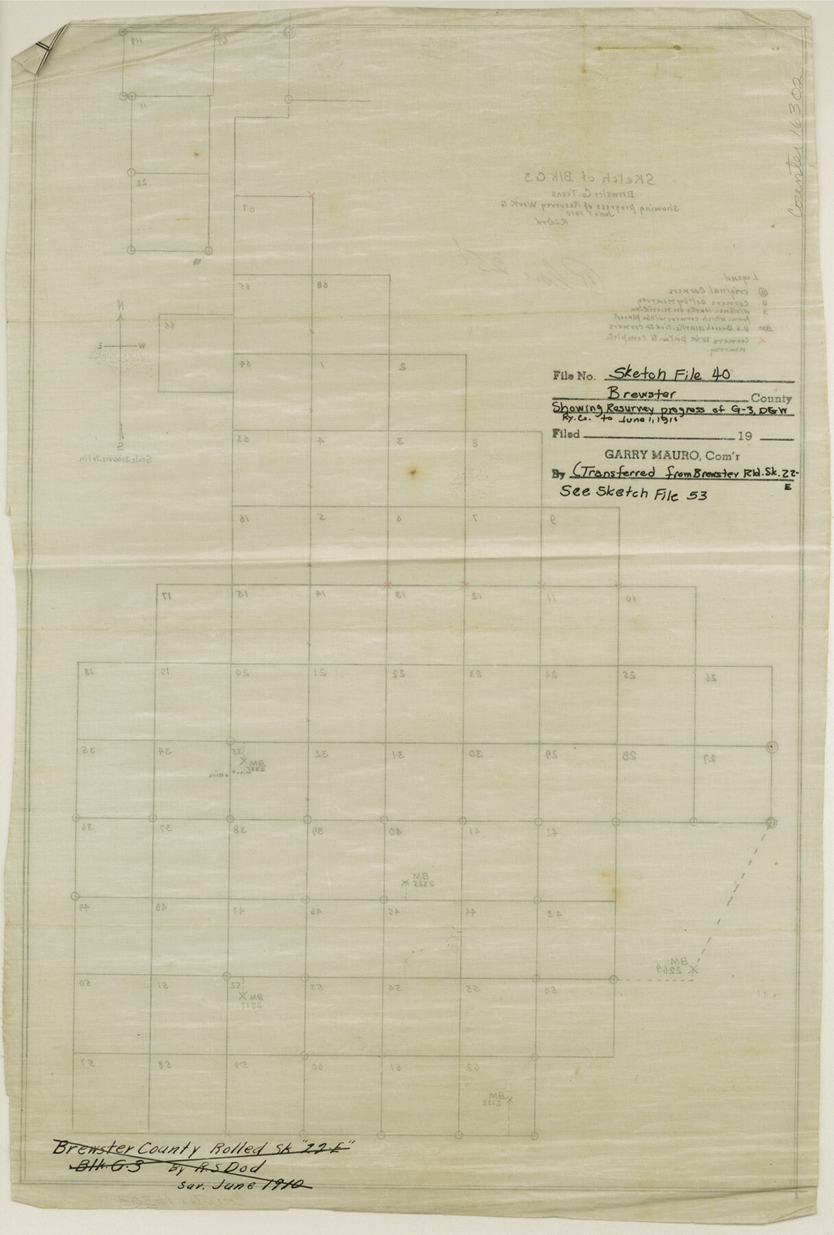
Brewster County Sketch File 40
Sketch of Block G-3
-
Map/Doc
16302
-
Collection
General Map Collection
-
Object Dates
1910/6/1 (Creation Date)
-
People and Organizations
R.S. Dod (Surveyor/Engineer)
-
Counties
Brewster
-
Subjects
Surveying Sketch File
-
Height x Width
15.2 x 10.3 inches
38.6 x 26.2 cm
-
Medium
linen, manuscript
-
Scale
1" = 2000 varas
-
Comments
See Brewster County Sketch File 53 (16361).
Related maps
Brewster County Sketch File 53

Print $94.00
- Digital $50.00
Brewster County Sketch File 53
1910
Size 13.3 x 8.9 inches
Map/Doc 16361
Part of: General Map Collection
Brewster County Sketch File 52

Print $16.00
- Digital $50.00
Brewster County Sketch File 52
1996
Size 14.1 x 8.8 inches
Map/Doc 16357
Terrell County Rolled Sketch 40

Print $20.00
- Digital $50.00
Terrell County Rolled Sketch 40
1943
Size 16.7 x 18.1 inches
Map/Doc 7944
Kerr County Rolled Sketch 16

Print $20.00
- Digital $50.00
Kerr County Rolled Sketch 16
1951
Size 40.6 x 31.1 inches
Map/Doc 9346
Harris County Rolled Sketch T2

Print $20.00
- Digital $50.00
Harris County Rolled Sketch T2
1916
Size 26.8 x 23.2 inches
Map/Doc 6145
[Ft. W. & R. G. Ry. Right of Way Map, Chapin to Bluffdale, Hood County, Texas]
![64644, [Ft. W. & R. G. Ry. Right of Way Map, Chapin to Bluffdale, Hood County, Texas], General Map Collection](https://historictexasmaps.com/wmedia_w700/maps/64644.tif.jpg)
Print $40.00
- Digital $50.00
[Ft. W. & R. G. Ry. Right of Way Map, Chapin to Bluffdale, Hood County, Texas]
1918
Size 37.7 x 84.3 inches
Map/Doc 64644
Chambers County Sketch File 40

Print $35.00
- Digital $50.00
Chambers County Sketch File 40
1925
Size 14.0 x 8.5 inches
Map/Doc 17677
Harris County Sketch File 110

Print $26.00
- Digital $50.00
Harris County Sketch File 110
2009
Size 11.0 x 8.5 inches
Map/Doc 89586
Victoria County Working Sketch 7

Print $40.00
- Digital $50.00
Victoria County Working Sketch 7
1945
Size 55.3 x 18.0 inches
Map/Doc 72277
Map of the State University & Public School Lands in Reeves and El Paso Cos.

Print $40.00
- Digital $50.00
Map of the State University & Public School Lands in Reeves and El Paso Cos.
1884
Size 39.1 x 56.3 inches
Map/Doc 2434
Map of Upshur County

Print $20.00
- Digital $50.00
Map of Upshur County
Size 18.5 x 23.2 inches
Map/Doc 76755
Flight Mission No. CUG-1P, Frame 53, Kleberg County

Print $20.00
- Digital $50.00
Flight Mission No. CUG-1P, Frame 53, Kleberg County
1956
Size 18.6 x 22.4 inches
Map/Doc 86131
Frio County Working Sketch 24

Print $20.00
- Digital $50.00
Frio County Working Sketch 24
1992
Size 47.0 x 35.2 inches
Map/Doc 69298
You may also like
Flight Mission No. CRC-3R, Frame 166, Chambers County

Print $20.00
- Digital $50.00
Flight Mission No. CRC-3R, Frame 166, Chambers County
1956
Size 18.8 x 22.4 inches
Map/Doc 84848
Donley County Sketch File B10

Print $24.00
- Digital $50.00
Donley County Sketch File B10
1938
Size 14.3 x 9.1 inches
Map/Doc 21272
Howard County Working Sketch 1

Print $20.00
- Digital $50.00
Howard County Working Sketch 1
1941
Size 19.7 x 25.1 inches
Map/Doc 66267
Refugio County Sketch File 6

Print $4.00
- Digital $50.00
Refugio County Sketch File 6
1856
Size 8.0 x 13.7 inches
Map/Doc 35249
Lamb County Sketch File 8

Print $6.00
- Digital $50.00
Lamb County Sketch File 8
1904
Size 8.5 x 7.6 inches
Map/Doc 29355
Flight Mission No. CRC-2R, Frame 194, Chambers County

Print $20.00
- Digital $50.00
Flight Mission No. CRC-2R, Frame 194, Chambers County
1956
Size 18.8 x 22.6 inches
Map/Doc 84772
Taylor County Sketch File 21

Print $10.00
- Digital $50.00
Taylor County Sketch File 21
1962
Size 11.3 x 8.8 inches
Map/Doc 37821
North Part Brewster Co.

Print $40.00
- Digital $50.00
North Part Brewster Co.
1914
Size 40.7 x 48.5 inches
Map/Doc 66730
Gulf of Mexico

Print $20.00
- Digital $50.00
Gulf of Mexico
1908
Size 18.3 x 26.9 inches
Map/Doc 72655
Orange County Working Sketch 33

Print $20.00
- Digital $50.00
Orange County Working Sketch 33
1957
Size 26.1 x 18.4 inches
Map/Doc 71365
Stephens County Working Sketch 35

Print $20.00
- Digital $50.00
Stephens County Working Sketch 35
1978
Size 14.5 x 26.0 inches
Map/Doc 63978
Parker County Sketch File 15A

Print $20.00
- Digital $50.00
Parker County Sketch File 15A
1875
Size 28.5 x 13.6 inches
Map/Doc 12144