Brewster County Sketch File 52
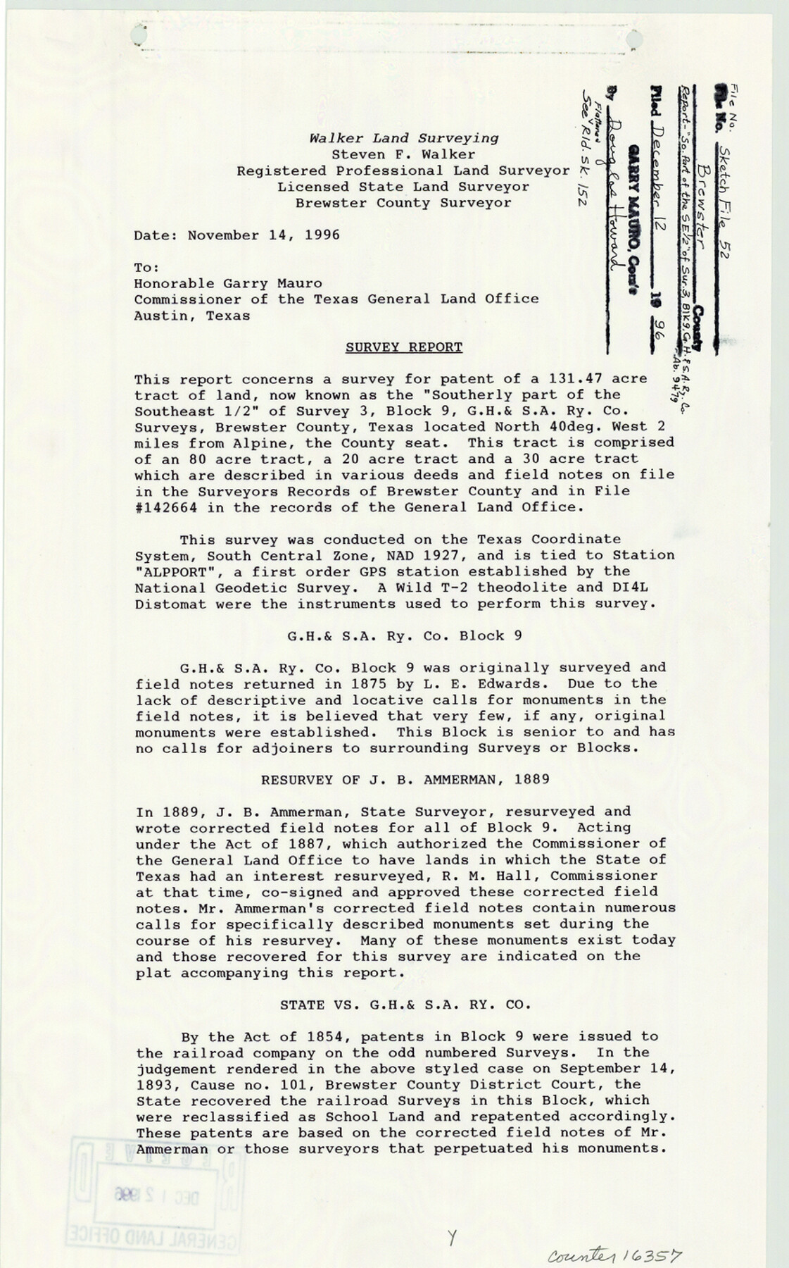
[Survey report accompanying plat of a survey of a 131.47 acre tract of land now known as the "south part of the southeast half" of survey 3, Block 9, G. H. & S. A. R.R. Co., abstract 9479]
-
Map/Doc
16357
-
Collection
General Map Collection
-
Object Dates
1996/11/14 (Creation Date)
1996/12/12 (File Date)
-
People and Organizations
Steven F. Walker (Surveyor/Engineer)
-
Counties
Brewster
-
Subjects
Surveying Sketch File
-
Height x Width
14.1 x 8.8 inches
35.8 x 22.4 cm
-
Medium
paper, print
-
Comments
See Brewster County Rolled Sketch 152 (5319) for sketch.
Related maps
Brewster County Rolled Sketch 152

Print $20.00
- Digital $50.00
Brewster County Rolled Sketch 152
1996
Size 28.0 x 36.5 inches
Map/Doc 5319
Part of: General Map Collection
Bailey County Working Sketch 6

Print $20.00
- Digital $50.00
Bailey County Working Sketch 6
1966
Size 37.0 x 34.5 inches
Map/Doc 67593
Burnet County Boundary File 9

Print $12.00
- Digital $50.00
Burnet County Boundary File 9
Size 14.1 x 8.6 inches
Map/Doc 50943
Hutchinson County Rolled Sketch 31

Print $75.00
- Digital $50.00
Hutchinson County Rolled Sketch 31
1908
Size 19.3 x 15.8 inches
Map/Doc 6292

Lamar County Working Sketch 1

Print $20.00
- Digital $50.00
Lamar County Working Sketch 1
Size 19.0 x 18.2 inches
Map/Doc 70262
Pecos County Sketch File 65

Print $6.00
- Digital $50.00
Pecos County Sketch File 65
1919
Size 16.7 x 11.9 inches
Map/Doc 33824
Bexar County Working Sketch 22

Print $20.00
- Digital $50.00
Bexar County Working Sketch 22
1986
Size 16.3 x 16.1 inches
Map/Doc 67338
Flight Mission No. DQN-5K, Frame 48, Calhoun County

Print $20.00
- Digital $50.00
Flight Mission No. DQN-5K, Frame 48, Calhoun County
1953
Size 18.7 x 22.2 inches
Map/Doc 84393
Comal County Sketch File 12

Print $4.00
- Digital $50.00
Comal County Sketch File 12
Size 8.4 x 11.3 inches
Map/Doc 19024
Fayette County Working Sketch 8

Print $20.00
- Digital $50.00
Fayette County Working Sketch 8
1981
Size 14.4 x 11.5 inches
Map/Doc 69172
Henderson County Sketch File 17

Print $40.00
- Digital $50.00
Henderson County Sketch File 17
Size 14.2 x 14.6 inches
Map/Doc 26361
Clay County Boundary File 16

Print $56.00
- Digital $50.00
Clay County Boundary File 16
Size 9.1 x 3.7 inches
Map/Doc 51422
You may also like
Coleman County Working Sketch 5

Print $20.00
- Digital $50.00
Coleman County Working Sketch 5
1928
Size 27.0 x 25.6 inches
Map/Doc 68071
[Galveston, Harrisburg & San Antonio Railroad from Cuero to Stockdale]
![64183, [Galveston, Harrisburg & San Antonio Railroad from Cuero to Stockdale], General Map Collection](https://historictexasmaps.com/wmedia_w700/maps/64183-GC.tif.jpg)
Print $20.00
- Digital $50.00
[Galveston, Harrisburg & San Antonio Railroad from Cuero to Stockdale]
1906
Size 13.6 x 34.0 inches
Map/Doc 64183
Brown County Sketch File 3

Print $2.00
- Digital $50.00
Brown County Sketch File 3
Size 8.3 x 5.9 inches
Map/Doc 16584
Working Sketch in Archer County

Print $20.00
- Digital $50.00
Working Sketch in Archer County
1924
Size 30.7 x 42.4 inches
Map/Doc 89980
Wilbarger County Working Sketch 14

Print $20.00
- Digital $50.00
Wilbarger County Working Sketch 14
1955
Size 24.8 x 21.7 inches
Map/Doc 72552
El Paso County State Real Property Sketch 4

Print $20.00
- Digital $50.00
El Paso County State Real Property Sketch 4
2012
Size 29.9 x 35.9 inches
Map/Doc 93701
Panola County Sketch File 30

Print $4.00
- Digital $50.00
Panola County Sketch File 30
1944
Size 2.8 x 8.9 inches
Map/Doc 33505
Shelby County Working Sketch 36

Print $20.00
- Digital $50.00
Shelby County Working Sketch 36
2011
Size 35.0 x 36.0 inches
Map/Doc 90093
Galveston County Rolled Sketch JS

Print $20.00
- Digital $50.00
Galveston County Rolled Sketch JS
1934
Size 34.0 x 41.9 inches
Map/Doc 9091
Cooke County Sketch File 21

Print $4.00
- Digital $50.00
Cooke County Sketch File 21
Size 9.0 x 6.7 inches
Map/Doc 19265
Montague County Working Sketch 21

Print $20.00
- Digital $50.00
Montague County Working Sketch 21
1952
Size 33.1 x 39.5 inches
Map/Doc 71087
