Brewster County Sketch File 53
[Reports, correspondence, and sketches relating to certain surveys in Blocks 16, G-3, G-16, and G-17 and their relationship to each other and to the Rio Grande]
-
Map/Doc
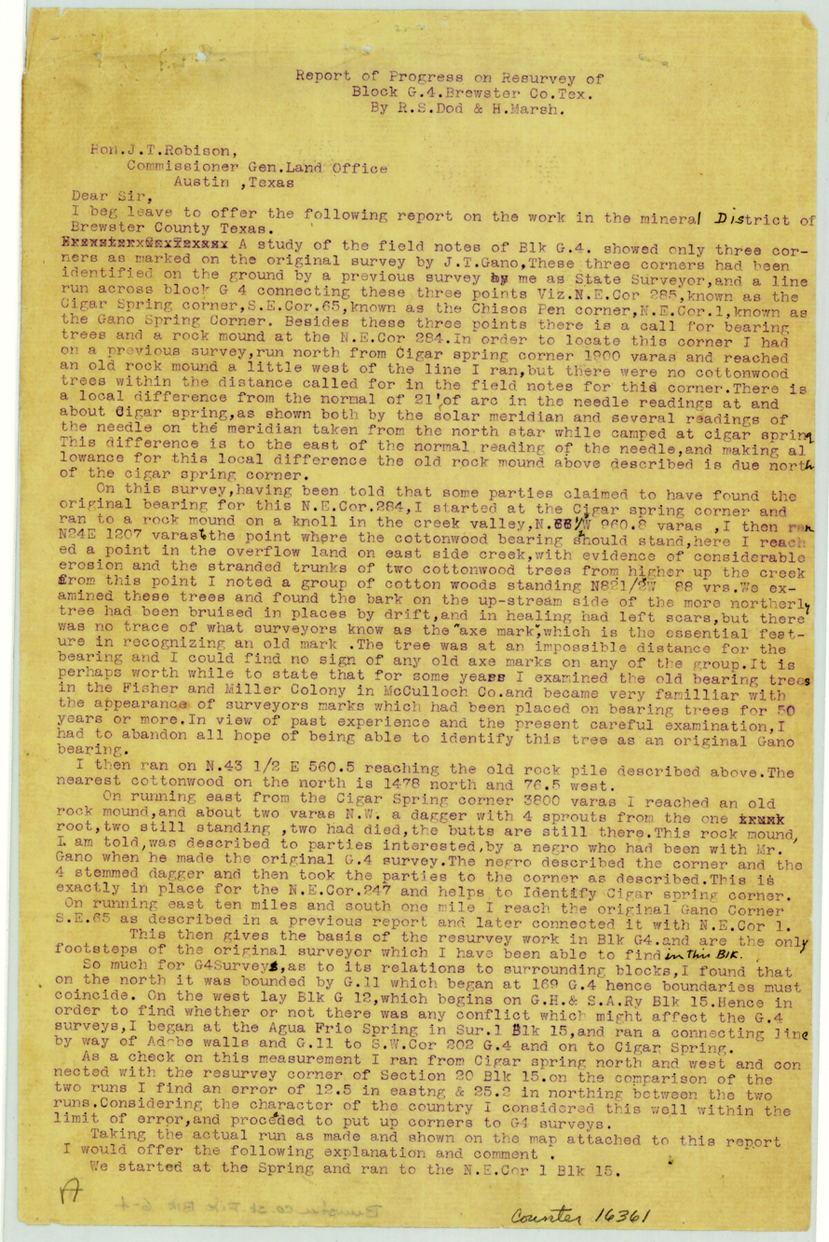
16361
-
Collection
General Map Collection
-
Object Dates
1910 (Creation Date)
1909 (Creation Date)
-
People and Organizations
R.S. Dod (Surveyor/Engineer)
-
Counties
Brewster
-
Subjects
Surveying Sketch File
-
Height x Width
13.3 x 8.9 inches
33.8 x 22.6 cm
-
Medium
multi-page, multi-format
-
Comments
See Brewster County Sketch File 40 (16302).
-
Features
Agua Frio Spring
Cigar Spring
Big Bend National Park
Pena Spring
Alpine
Chisos Mine
Rio Grande
Grand Canyon
Related maps
Brewster County Sketch File 40

Print $6.00
- Digital $50.00
Brewster County Sketch File 40
1910
Size 15.2 x 10.3 inches
Map/Doc 16302
Part of: General Map Collection
Galveston County Rolled Sketch 43A

Print $20.00
- Digital $50.00
Galveston County Rolled Sketch 43A
Size 16.2 x 20.3 inches
Map/Doc 76005
1988 Land Use - El Paso, Ciudad Juarez and Vicinity

Print $20.00
- Digital $50.00
1988 Land Use - El Paso, Ciudad Juarez and Vicinity
1988
Size 34.2 x 25.1 inches
Map/Doc 87369
Goliad County Sketch File 20

Print $38.00
- Digital $50.00
Goliad County Sketch File 20
1887
Size 8.8 x 12.3 inches
Map/Doc 24265
A New Map of the Whole Continent of America. Divided into North and South and West Indies, wherein are exactly decribed the United States of North America as well as the Several European Possessions according to the Preliminaries of Peace…

Print $40.00
- Digital $50.00
A New Map of the Whole Continent of America. Divided into North and South and West Indies, wherein are exactly decribed the United States of North America as well as the Several European Possessions according to the Preliminaries of Peace…
Size 22.0 x 48.7 inches
Map/Doc 95136
Chambers County Sketch File 57

Print $13.00
- Digital $50.00
Chambers County Sketch File 57
1935
Size 14.7 x 8.9 inches
Map/Doc 18102
Right of Way and Track Map Texas & New Orleans R.R. Co. operated by the T. & N. O. R.R. Co. Dallas-Sabine Branch

Print $40.00
- Digital $50.00
Right of Way and Track Map Texas & New Orleans R.R. Co. operated by the T. & N. O. R.R. Co. Dallas-Sabine Branch
1918
Size 24.3 x 55.9 inches
Map/Doc 64156
San Patricio County Rolled Sketch 38A

Print $20.00
- Digital $50.00
San Patricio County Rolled Sketch 38A
1958
Size 26.6 x 23.5 inches
Map/Doc 7589
Fort Bend County Working Sketch 13

Print $20.00
- Digital $50.00
Fort Bend County Working Sketch 13
1946
Size 29.0 x 29.3 inches
Map/Doc 69218
Madison County Working Sketch Graphic Index

Print $20.00
- Digital $50.00
Madison County Working Sketch Graphic Index
1922
Size 29.4 x 47.6 inches
Map/Doc 76628
Flight Mission No. BRE-1P, Frame 69, Nueces County

Print $20.00
- Digital $50.00
Flight Mission No. BRE-1P, Frame 69, Nueces County
1956
Size 18.3 x 22.1 inches
Map/Doc 86651
Leon County Working Sketch 10

Print $20.00
- Digital $50.00
Leon County Working Sketch 10
1951
Size 21.5 x 17.3 inches
Map/Doc 70409
La Salle County Sketch File 13a

Print $8.00
- Digital $50.00
La Salle County Sketch File 13a
1878
Size 12.7 x 8.0 inches
Map/Doc 29479
You may also like
[Southern Part of County]
![91905, [Southern Part of County], Twichell Survey Records](https://historictexasmaps.com/wmedia_w700/maps/91905-1.tif.jpg)
Print $2.00
- Digital $50.00
[Southern Part of County]
Size 9.8 x 7.6 inches
Map/Doc 91905
Rusk County Sketch File 19

Print $4.00
Rusk County Sketch File 19
Size 13.0 x 8.2 inches
Map/Doc 35526

Harris County Rolled Sketch 26

Print $20.00
- Digital $50.00
Harris County Rolled Sketch 26
Size 28.2 x 41.3 inches
Map/Doc 6094
Railroad Track Map, H&TCRRCo., Falls County, Texas

Print $4.00
- Digital $50.00
Railroad Track Map, H&TCRRCo., Falls County, Texas
1918
Size 11.7 x 18.5 inches
Map/Doc 62831
Sterling County Rolled Sketch 17

Print $40.00
- Digital $50.00
Sterling County Rolled Sketch 17
Size 61.0 x 48.4 inches
Map/Doc 9949
Hardeman County Working Sketch 11

Print $40.00
- Digital $50.00
Hardeman County Working Sketch 11
1960
Size 40.0 x 58.1 inches
Map/Doc 63392
Flight Mission No. BQR-22K, Frame 44, Brazoria County

Print $20.00
- Digital $50.00
Flight Mission No. BQR-22K, Frame 44, Brazoria County
1953
Size 18.6 x 22.3 inches
Map/Doc 84128
Dallas County Sketch File 12

Print $20.00
- Digital $50.00
Dallas County Sketch File 12
1853
Size 25.4 x 25.2 inches
Map/Doc 11284
Hansford County Boundary File 3a

Print $80.00
- Digital $50.00
Hansford County Boundary File 3a
Size 15.3 x 64.7 inches
Map/Doc 54275
Gillespie County

Print $20.00
- Digital $50.00
Gillespie County
1873
Size 16.0 x 22.4 inches
Map/Doc 3580
Jim Wells County Working Sketch 9

Print $20.00
- Digital $50.00
Jim Wells County Working Sketch 9
1948
Size 34.1 x 38.9 inches
Map/Doc 66607